
An Upper Air Circulation (UAC) has formed over SW Bay of Bengal near the Srilankan coast and extends up to 1.5 KM above sea level. Another UAC has formed over the Andaman Sea and extends 3.1 km above sea level. Yesterday’s UAC over Lakshadweep (0.9 KM above sea level) persists.


Rain or thundershowers likely in one or two places over South TN and in some parts of Kerala. Dry weather likely to continue for next 24-48 hours over North Tamil Nadu.
Weather Models are pointing to some action in the Bay towards early/mid next week which could herald NEM into TN. More clarity will be available towards the end of this week.
Chennai – Sky will remain clear, with temperature to be around 33C.
Coimbatore – Partly cloudy sky with light chances of rain. Day temp to be around 32 C.
Madurai – Day temp to remain moderate with temp touching 33C.
Tiruchirappalli – Partly cloudy sky expected with temp around 34-35C.
Vellore – Sky will be partly cloudy with day temp to be around 32C.

Wow. Unbelievable, hopefully it turns out true
Super
omg thn holiday ;(
Lots of pop ups se of chennai
No need to see radar till wednesday
Wow GFS!
http://earth.nullschool.net/#2015/10/27/1800Z/wind/surface/level/orthographic=80.04,12.18,2274
super thts our cyclone ahh .i think tht need to form east of sri lanka why it formed there is it good for us thn tht position?
This is the gfs forecast!
guys sykmet also predicting vry hvy rain on 29 th atleast 200mm.;) woow first time iam seeing they puting this much mm.
Skymet has to follow others. No use following skymet.
thq 😉
Everybody is going with GFS!
lets see wheter its gives hand to us or not 😉
gud morning blogers 😉
Wow..it looks ER wave will be countering with MJO at phases 2 & 3. This is very good sign for TN, especially Chennai (NTN/SAP) in terms of the forecasted system to make exactly at Chennai. Whenever ER wave encountering MJO at close to phase 2 then there will be high chances for Chennai to receive record rains.
For the above scenario, recent July 2nd half Chennai record rains will be perfect example. So keep fingers crossed by taking “ECMWF” forecast as pinch of salt.
ER-wave: http://cawcr.gov.au/staff/mwheeler/maproom/OLR_modes/f.3.n1ER.html
MJO: http://www.cpc.ncep.noaa.gov/products/precip/CWlink/MJO/CLIVAR/ALL_emean_phase_full.gif
click on the MJO-image to see recent one
U still have hope on a system for Chennai
ha…ha.. its Chennai-express only…no need to change my earlier forecast even King-Gigantic model ECMWF showing N/NE track 🙂
North/north east track means Chennai right
As per ECMWF its Bangladesh LF 😦
Rao sir Bangladesh landfall systems I have heard a lot in April to July period.
yes, most pre-monsoon systems will target Bangla to Myanmar stretch.
Super Dr.Rsrao , I don’t want to see Ecmwf models from now on . Going to see a Rao model 😆
lol 🙂
MJO just touched the amplitude +1 at the junction of phase 1 & 2.
MJO-dynamical: http://www.cpc.noaa.gov/products/precip/CWlink/MJO/CLIVAR/clivar_wh.shtml
MJO-OLR: http://mikeventrice.weebly.com/mjo.html
Due to some special features in MJO and other indexes (especially IOD with decreasing forecast to neutral), there will be high chances for total 3 tropical systems (minimum tropical storms with rain filled) starting from October last week to November last week.
All these 3 tropical systems will target TN/AP without any N/NE curve pattern above AP-latitude.
Good morning friends 😁
As usual Ecmwf expecting a NE curve . It wouldn’t possible it seems . If it is possible , then it will give massive rains to entire Tamilnadu including Chennai . And it will weakens when goes above Chennai latitude.
But Gfs is the only hope for us . Lets hope on god . He will change everything .. Hope for best 😁
First system especially made for Chennai and north coastal Tamilnadu
http://www.monsoondata.org/wx2/prec.html
Lot of popups to the East of Chennai
appo innike mazhaiya
Flash…Pre-NEM isolated rains alert..as NEM-2015 onset scenario inching very close any time soon after 26th October, the chances for pre-NEM showers increasing hour by hour. Enjoy the nice climate ahead. Wish this NEM-2015 a grand success:)
the pops are heading in the right direction:-)
ECMWF is also not always correct
It completely failed during typhoon Debby in 2012.
each model has their calculations
ECMWF got more popularity during cyclone sandy as its prediction became true when all the models failed.but we cannt believe ecmwf too always.No model is king
Exactly. No model is king.
The pops have moved 40KM west.. now 60KM from Chennai.
GFS is now consistent with another massive spell by November 4th
Shall we rule out ECMWF runs??
Why ?
System can not move in that N/NE direction.
It can, good possibilities. Why do you always jump to conclusions before the event actually happens :p
How you are saying that it will move N/NE??
It is the WD factor we need to study that for understanding the N NE movement possibility
Yes sir. But this WD may not be exhibiting any effect on October system before landfall.
Anyways, appreciate your courage.. Let’s see what happens
Ha..ha..👍😆
Latest ECMWF run predicting unprecedented amounts for Chennai 😮
With system or without system.
With system
Thambi… All I need is normal 195 mm..already with 84 mm
So normal October is possible?
All models say “yes” to your question.
Is it?
Good Morning all.
As we see the short range predictions of two major forecasting models, its getting clear that scenario shown by ECMWF may become true given the environmental conditions. GFS scenario of a strong system just offshore in a flash is getting questionable. I would have loved this scenario presumed by GFS unless for the short range.
Expecting major change in model outputs by GFS in today’s run. All said and done, if it rains at least decently next week, I would take it for October regardless of it entering into N Bay.
Let’s not expect a drama next week. We may get our bird”s share.
Again ECMWF will be right? GFS not considering same environment like ECMWF did??
Gfs might comes true
It finally comes down to the accuracy and the loyalty of the models. We may not see ECMWF changing the script as late as this.
But BOB is entirely different and typical basin.
There is still time to change the script, better do it soon.
AccuWeather artistry has come out well this time ! Qualified Photoshop Artists!!
They know how to attract the eyes!
Ecmwf is going to fail this time!
Would love that though. All we need is a normal October.
This is for sure. We are going to see king’s failure😆😆😆
Good morning guys! 🙂
Massive rains are going to occur from oct 27th night to atleast nov 2nd!
Get ready for real NEM.
Less than a week away🤗
Windy conditions are going to start from 27th accompanied with heavy downpour☔️
A real challenge for the models at most of times is to locate the initial position. GFS continues to keep that initial action just offshore SL and east of it , and developments from there, whereas ecmwf feels a slight westward push in the initial stages.
Already vorticities developing just east of SL at 850 & 700 hpa levels.
Vela is going to fail big time this October. He predicted 300 mm. We might get much more than that as per current gfs.
Lol.
Kea Vela sir told min 300mm ….
We teased his prediction when he put forward SOI. But it looks Vela prediction on right path. 1st time in history 2 SOI guys (me and Vela) rocking our blog.👍😆
Lol😆👍
Worry started now KEA predicting more rains!!! – Just see he said SA will win and we all know the results
This joke is old now. Better change. I have been predicting unprecedented rains since beginning of NEM 14.
Since beginning of NEM 2014!
Yes, I said forget nem 14, nem 15 will rock
But did you say will get rains in Oct, you have been saying in November
Spot on…actually he predicts very bad October
Did I? Ask PJ. He was angry I was with Vela
Yes I said. But I predict rains for whole nem, I don’t go month by month.
@RsRao, what’s after system 1? When is #2 expected
Next is Diwali system!
1 week gap?
Didn’t we expect a bumper November?
We need systems at lesser intervals
All depends on first system’s failure. Let it fizzle after it moves to N Bay. If it strengthens there, it will not help our cause.
It will fizzle after landfall!
But it ll come after diwali… Nammaku luck ah illa
Yes, but this time, we may see a good System either before or after Diwali. Nature just can’t do wrong this time.
By November 2nd week, before that Arabian system will evolve in November 1st week. Again November last week one more system. Interestingly all 3 BOB systems (minimum tropical storms) most probably cross at TN/AP. No single system will go towards Bangladesh/Myanmar before November ends.
This is not good. Only 2-3 systems this NEM
Oh..mistaken it’s only upto November end. Actually further systems forming even in December too. Overall NEM-2015 is very active season.👍😆
Dec is always for tn will be it a cyclone
Spot on
Watchout for some circulation ( trough of low) in next 24 hours
Rains from Sunday itself?
Hi friends, lots of red dot in bay of Bengal, any one tell we have rain afternoon?
Some isolated showers… Still due to some hpa dominating, those popups ll die soon.. It won’t sustain
GFS does continue to show and rely on the good to strong poleward outflows.
You expect GFS scenario to happen at least by 40% probability?
I am not sure on the probability. Apart from initial location , both models have varying environmental conditions too.
Looks like phailin or hudhud
Outflows can give monster like idea and look even for basement weak system.
Arb sea system?
Low marching westward and crashing into Somalia.
This picture not at all clear
Why?? what is not clear..?
Wow..it looks cat.1-3 system (hurricane force winds) crossing at Chennai??
Maximum gusts should be around 230kms/hr with winds touching 100kms/hr as per the current condition.
130*
Reminds me of nisha
But this will do more damage than Nisha due to direct crossing at Chennai.
I dont think this will develop into a big one.. Max tc status
That itself we can withstand.
Anything above 80km/hr is dangerous for our city to withstand.
Can’t *
It’s time to test the city’s infrastructure!
Very much.
But by keeping MJO and ER wave actions in mind, this will develop to a cyclone. Moreover most of the tropical pulses in 2015 intensified rapidly till today. So once LPA forms then there will be high probability for rapid intensification, but with below cat.3 system.
Forget cat-3 storms to happen.
Its more close to land so chances are less.
Like jon said a TC on cards at max a cat-1.
In our basin proximity to land even can not intensify to cat.1, but 2015 is a strong Elnino year with abundant absolute moisture everywhere. So rapid intensification possible even close to the land.
Yes that’s why I said at max a cat-1 can happen.
Let it intensify why worrying? We can enjoy freak weather after manymany years
Lol even I’m eagerly waiting for such freak weather in Chennai.
Not possible since system likely to form very close to shore.. cyclone needs vast open waters for rapid intensification
Who is not believing next week rains?
I am believing in 200%👍😆
Everyone does.
Mind says not to believe but eyes says to believe
What about yourself?
500%. It just can’t fail. 200 mm guaranteed
Super . Good to hear that from you! Let all the school kids here get a holiday or two
I am expecting 2 next week let’s see
OMG!
what happend?
Just now told my parents about a possible cyclone landfall, they are in disbelief!
Avolo nambikai
Good morning!
Blog active!
Going to school??
no!
😛
Why no school today?
is there!
but i didnt go!
Okok 😂
Guess 29th should be the day for the maximum amount of rainfall to happen.
Yes.. 27,28,29,30
Even nov 1st,2nd.
Apidiyae Dec 31 varaikum extend panlam
Lol😂
You didn’t get what Hrishi was saying. He said we will get maximum rain on 29th
I got it jii…..any one of that four days
he told yes!
http://earth.nullschool.net/#current/wind/surface/level/overlay=relative_humidity/orthographic=-274.54,11.67,1723
circulation seen more deep now east of srilanka coast
The frequency of hurricanes drops off dramatically during late October and November. In December, storms of this nature rarely occur. The main reason is that the westerly upper-level winds strengthen and press farther south, breaking down the Atlantic ridge and increasing wind shear in the typical hurricane formation zone. In addition, the ocean cools significantly during November. That means less fuel for any tropical storm that might try to take shape.
— WeatherWhys
Deluge is 70% confirmed as of now..why some of them are worried
My exams need to get postponed relying on it
Better you don’t trust then, it will pull your legs too
Better study 🙂
Maximum deluge on 29 th.
Let’s see
See..u itself not confident.. How come others ll be sure?
2/3rd deluge confirmed
Why 2nd/3rd?
I’ve given weightage
Any reason?
Not specifically
U r only 70% confident?
Because quantum of rains is uncertain
Enna nadakuthu inga!
Popup with in 30km radius!
It will fizzle
Rao sir a cat 2 or cat 3 system never occurred in Chennai history. Is it because of strong elnino sir we can expect direct hit on Chennai
Lol…super cyclone ( above cat 5) crossed chennai
So strong elnino this can happen again
There has been strong cyclones crossing chennai.
It’s due to combination factors more than one. But strong cyclones previously occurred at Chennai.
Close to 40cm expected by my weather app now.
Lol😂
Lol… i have never seen COLA expecting 36 cm !!!
Haha I didn’t see Cola.
I was just checking my weather app.
see Cola it is mouth watering like your app.
Hehe I saw.
Hrishi October 2005 54 CM in a single day
Nope.
40 CM on a single day
Lol.
omg… Chennai Cannot Withstand!
CHENNAI ORU VANICE
Like I said anywhere between 200 and 500 possible in next 10 days
Remembering Goundamani joke, when he wins lottery ticket and asking whether to buy this street/or something to buy now, as if he is going to get lot of money.
My rg capacity is 11cm..will it b enough??
Keep Bucket…I am Keeping That RG will Be Thrown Away With Those Winds!
ok
Nope 😂😂😂
No way on earth.
Dear All,
The much expected pre-NEM KEA meet (2015) is proposed to be held on 25.10.2015 at 4.00 pm in Semmozhi Poonga (near Gemini opp to American Embassy). All are welcome. Please send in your confirmation to keaweather@gmail.com.
Cyclone Brothers, Maddy (hopefully), Partha, Captain, Vinod all will be there. There will lot of debate GFS vs ECMWF. Steering of cyclone. The garden has a parking lot that can accommodate around 100 cars and more than 500 two-wheelers. An entry fee of ₹ 15 is collected from all people above 10 years of age or 130 cm height.
Semmozhi Poonga – http://redripetomatoes.blogspot.in/2011/09/semmozhi-poonga-green-oasis.html
Wow..nice timing PJ👍😆
We have organised it on a Sunday so that all can make it.
Is there a giant screen TV for cricket match?
ya!
i want!
NEM > ODI
ONLY NEM
Match? 😛
sir!
where is the NEM photo contest?
no news abt it?
Good Morning,
Tomorrow i am going to Trichy, will be back by Monday morning only,
I could not attend this meet, sorry to all.
gfs RUN STARTED!
Then Start Posting! I am In 2G.
No told pj sir!
anyone post it.
kk
Jon can post. He has 100 mb PS speed.
Ehsan why bring vela now lets enjoy the rains. Vela never predicted any cyclones. Then if a cyclone come and gives rains. He cant take credit.
sir can i post gfs runs?>
yes
Yeah…he said no cyclones this year
I am only has faith in hyperactive NEM-2015 interms of cyclonic systems starting from discussions with guest11k at SWM season based on decreasing +ve IOD to neutral with strong Elnino. Now it’s revealing 👍😆
👍😀
I am not expecting any cyclones in BOB in NEM 2015 . . . .
I am with Rains…. Only Rains….
October – minimum 300mm
November – Minimum 425mm are guaranteed for Chennai
Hardly, 4 days to go. It would be a risk discarding GFS now. In short range, even ECMWF cant compete with GFS.
East looks dark here.
HPA Dominating?
Nah..Dark clouds I meant.
Popups coming!
consistent!
This will be consistent for sure.
Both models expect this.
The whole east coast will benifit as per GFS
GFS
expects the low to form in next 6 hrs!
Circulation already seen.
hmm!
Navegem agrees with GFS on early formation.
Matter of a day or 2 before IMD announces LPA formation.
welcome pre -NEM showers?

Already dark here.
You itself tell the reason why it won’t reach
Can we say band coming band coming
Possible today.
we are in oct 23 , no premonsoon , its NEM showers
HPA is still dominating will get rains
How will be get rains if HPA is dominating?
Little cloudy in Anna Nagar west
Sel, looks like outer band of LPA
athukullava? i see there is an area of positive vorticity along tn coast but still there is no convergence out of it..
Band Coming Band Coming!! (ODM Style!)
It looks awesome. It predict 354 mm..
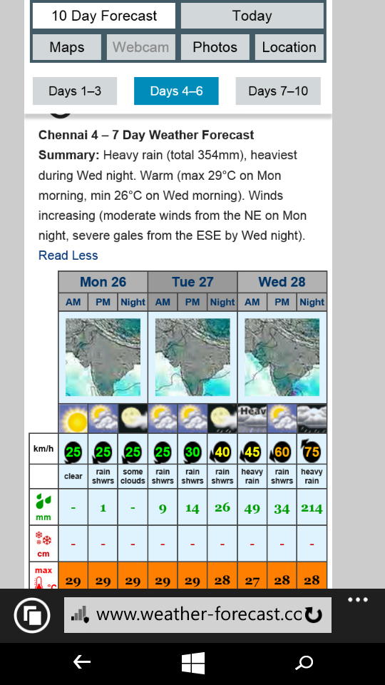
18 Hour – Updated!

LPA staying near SL for some time.
Imd announces NEM will start around 27th, this year nem will be normal, – courtesy Puthyia thalaimurai
then why did they give above normal rainfall in IMD website?
overall this year nem will be above normal for entire T.N, Chennai may fall in Normal category
They said 88-90% chances of above normal for Chennai.
what ever it may be, hope our nem will benefit our T.N on the whole
Its time for n.tn, s tn has good chance till Dec last week
but for anything we depend on South, then it will be mutual benefit only,
Not every time
No news In any dailies
No movement seen.
OMG!
No movement there!staying tilll 25th near srilanka!
Similar to previous runs.
Chill.
hm!
yes
Started with bright sunny day, now to overcast..East looks dark..
sel here is ur vorticity.
http://tropic.ssec.wisc.edu/real-time/windmain.php?&basin=indian&sat=wm5&prod=vor&zoom=&time=
Similar to yesterdays run.
IMD again repeats easterlies wave to hit from Oct 27. Mentions UAC east of SL
East.SL on the verge of getting flooded with LPA staying there for around 3/4 days.
radar not getting updated!
Though worldwide in its consequences, El Nino originates in the eastern
tropical Pacific Ocean, when normal weather patterns shift in a way that
allows the ocean to release large amounts of stored-up heat into the
atmosphere.
http://timesofindia.indiatimes.com/world/us/2015-likely-to-be-hottest-year-ever-recorded/articleshow/49498147.cms
Mid level ACC has weakened since yesterday. It was strong in NE Bay, today the circulation got affected. WD intensifying is clearly seen above 15N latitude.
Will it affect our system??
pocha!
With upcoming UAC, will wd effect system path.
after crossing chennai latitude, after 30th it might as the system moves towards north direction and interact with WD.
sir,
till thn it will cross chn and give rains ah?
pls tell sir!
rainfall cannot be refrained by any other sources, we are in for huge pouring…
hmm!thanks very much!
Moving North now.

Situation conducive to receive some showers today itself
HPA dominating then how?
If GFS keeps its forecast consistent in today’s runs then it will be 100 percent sure shot of deluge for TN and South AP.
GFS is the most reliable for short range weather prediction. I just verified the track errors of GFS and ECMWF for some cyclones and it is GFS which is the best in short range prediction some times
Circulation is slightly tilted towards ne, omg Bayama iruku
No Bayam
That deep vorticity ,,,,,
no problem!
Expected!
Moving ?NE
no..it will move north and west!
Supreo super.
Moving northwest
Then NE is a fiction.?
rao there?
Yep👍😆
sir will wd affect chn rains as said by partha sir?
No way👍😆
🙂
Super!
Dr Rao will always be there 24/7 365 days
Yes sir due to Amalapuram green field effect😆👍
Amalapuram Rao, you rock.
GFS king.
OMG!
intensified a lot!
Becomes dark & cloudy in perumbakkam
I am in sholinganallur now, where are you in perumbakkam?
Near perumbakkam chruch.
i go everyday to my office in sholinga in that way from rajakilpakkam.
I am audit executive working in CA firm presently works for client in nellore came to Chennai for pooja holidays
Athan naan sonnen
But more of haze & dark
Look at this GFS track mean error is less than ECMWF in short range…however ECMWF is best in medium range
What about short range
We can give priority to GFS in Short range.
Deluge confirm.
Moving NW,
Looking cloudy & dark In perumbakkam
Dandanakka!
Namba mudiyavillai(not possible for us to believe). Will this happen on 28th October ?
what is near west of srilanka?
Just a vorticity.
oh kk.after seeing i doubted!
Next run will tell us.
GOM & STN coast
Dangerous!
Cat 1 cyclone
OMG OMG OMG.
DD close to coast 😮

minimal cyclone!
For excitement one can watch for models. But this exactly follows perfect NW-track like 1982 Chennai system. Nothing can deviate it’s track. No worries as its sure shot of Chennai cyclone-2015. 1982-chennai TS track: https://en.m.wikipedia.org/wiki/1982_North_Indian_Ocean_cyclone_season#/media/File%3ACyclone_04B_1982_track.png
Paaru paar nalla paaru high rain activity paaru
PJ
I am not expecting any cyclones in BOB in NEM 2015 . . . .
I am only with Rains….
October – minimum 300mm
November – Minimum 425mm are guaranteed for Chennai
:)!
Even no tropical storms??
So if this becomes cyclone, u should not get credit.
He is smart, as he did not ruled out WML/D/DD/tropical storms PJ😆
Raoji….
at the maximum the system may get intensity upto Depression…..
So wording is so important.
Surely…. I won’t take any credit . . .
Outerbands already touching Chennai.
so? Rains From 26th Night!
27th.
Oh OK!
sai..keep ur old pic!
Which?
vijay..
i cant identify u !
Lol… Venam pa..
OMG!
GFs rocks!
OMG! 100 Likes For This Pictures!
preserve this image
Cat-1 near our coast.
Moved north northeast
NE then N/NW.
no it moved east again coming near chn!
West*
no from GOM iit slightly moved east and to come to chn it moved west!!
Ha..ha…For excitement one can watch for models. But this exactly follows perfect NW-track like 1982 Chennai system. Nothing can deviate it’s track. No worries as its sure shot of Chennai cyclone-2015. 1982-chennai TS track: https://en.m.wikipedia.org/wiki/1982_North_Indian_Ocean_cyclone_season#/media/File%3ACyclone_04B_1982_track.png
Everything going according to DrRao script👍👍.
Long live rao ji
THis is unbelievable!
I am not surprised😆👍
asusual
We are thrilled . . . .
Hats off sir, great predicting
Moving NE?
people are talking about next week system. now see radar picture. plenty of showers close to chennai coast. may reach by noon.
we will get intermittent useful rains from noon.
ss
Jaw dropping 😮

Mouth watering, omg this is getting better and better
See Deluge This Time For Chennai Yellow and Red Near To Chennai.
During NEM onset time the moisture should come from extreme south bay and it moves northwards and cover up to south ap, this is what happening now, WV insat shows the same. In the past 3 days it has moved north considerably.
Ha..ha..any BOB standard model runs 1000 times before the coming system formation, each run will be directed towards Chennai only. This system is Elnino-locked Chennai system like 1972, 1982, 1994, etc. so one can lock this system for “Chennai” only.👍😆
Pre NEM showers in the blog 🙂
Oh-oh.

Aiyooyo
Going north??
Yes.
Superb!
We will get battered!
from southern bands too!