
Chennai might need to wait atleast another week for any chance of rain. With has already deficit 115 mm and it might even touch 200 before any rainfall occurs.

Chennai might need to wait atleast another week for any chance of rain. With has already deficit 115 mm and it might even touch 200 before any rainfall occurs.

Latest ECMWF continues to take TY Hagupit in towards Philippines , LF close to Tacloban(LF area of TY “HAIYAN” , 2013), and in the further days , shows LF on the Vietnam coast , and later the remnants are last seen close to the northern most portions of Gulf of Siam(Thailand)
Will this TY send the much needed pulse into Bay ???
Answer remains uncertain ……:(:(
Latest QBO value down to 23.65 from 23.85
according to the expectation. But still its very less difference 😦
So we cannot expect any strong system in BOB this December.
Looks like that.
But sidr-2007 happened in -QBO yr, but with SOI greater than +10. Not expecting that SOI (even IOD forecasted to go -ve) will to become too +ve during this December.
So in conclusion we can not expect strong systems likecat.1 or above, but can expect only weak systems like minimal cyclone/D/DD.
Ok. Will Hagupit remnant enter BOB. As per latest ecmwf, hagupit targeting central vietnam instead of extreme south.
too bad. As QBO & IOD parameters fixed (we know their outcome), now SOI will influence its fate at BOB.
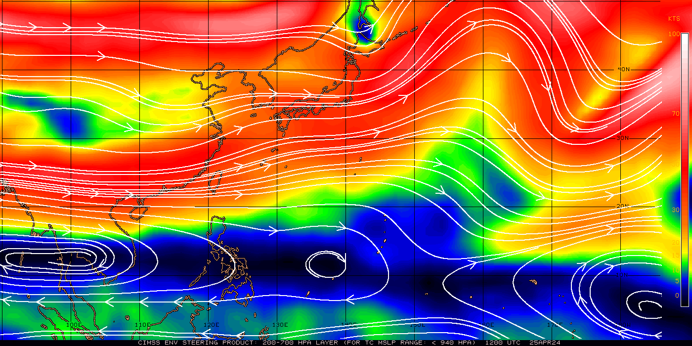
I am expecting SOI to come to the rescue of TN. Look at the strong easterlies coming from the south china sea in the diagram posted by Goku.
Even arctic forum expecting sudden burst in easterlies from east-pacific region.
In that case minimal D/DD/minimal cyclone is guaranteed if the pulse survives at BOB. So hope for the best.
That’s great news. It looks like CP will start to cool in coming weeks.
What is the cause of this sudden burst of easterlies from east pacific region.
Also if Hagupit take GFS path( travelling in NNE direction). Will BOB will be able to throw a pulse on its own..?
Without increase in SOI, IOD or QBO (that too in the absence of MJO), we can not expect BOB to throw a pulse.
Regular easterly rains may occur if SOI increases. Otherwise those also very difficult 😦
Absolutely
Is there a chance for rain early next week?
Looks like typhoon hagupit surprised the forecasts and turned super typhoon, and this strength forecasted to retain till phillipines just like ‘super typhoon haiyan-2013″. So Phillipines need to take emergency precautionary measurements.
Super typhoon hagupit: http://www.usno.navy.mil/NOOC/nmfc-ph/RSS/jtwc/satshots/22W_031732sair.jpg
120kph wind gust just recorded in Okinawa due to the cold surge that is heading south to impact #hagupit http://www.data.jma.go.jp/obd/stats/data/mdrr/rank_daily/data00.html
Raw T numbers from satellite nearing 7.5. 140-150 knots intensity possible in next 6-12 hours #Hagupit http://twitter.com/RyanMaue/status/540295095078363136/photo/1
If Hagupit sneaks into gulf of thailand n andaman sea, we can expect easterlies…no major system possible until 15th dec.
Will the easterly effect chennai also ah ?
Lets watch Hagupit for now
good morning all, drastic reduction in comments past a week, now not even touching 50.
NEM winds are enemy no.1 this Nov. and Dec. which spoiled our rain chances by pushing the plum easterlies towards south
Let’s welcome back winter. Looks like NEM has no chance of a revival, even if a system comes we will get minimum(<50 mm) rains from it
Kea comes back with a bang…
There is always a NEM 15 to look forward to. But before that some dry weather, then a long summer, then a SWM.
Still lots of things ahead for us. Only 10 more months for next NEM
Chumma idhaye solli bore adikaatheenga..try something different.. 😀
Kea, you are spot on. Any revival would have minimum impact in Chennai. Lets enjoy the chill of winter.
Did Ramanan sir say any Remnants coming to Boss of Bays??? 😀
No boss …..
GFDN takes Hagupit to 12.5n 117e by 8th Dec with 60knots.
An
inspirational speaker said, �The Best years of my life were spent in
the arms of a woman, who wasn�t my wife.� Audience was in shock and
silence. He added, �She was my mother.� A big round of applause and
laughter followed.
A very daring husband tried to crack this at
home. After dinner, he said loudly to his wife in the kitchen. �The best
years of my life were spent in the arms of a woman, who wasn�t my
wife.� Standing for a moment, he tried to recall the second line of that
inspirational speaker. By the time he gained his senses, he was on a
hospital bed, recovering from burns of boiling water !
Moral : Don�t copy. If you can�t paste �.!!!
Unlike · · Share
Revival Pulse to enter BOB on Dec 14th…!
Revival pulse or whatever we will get decent rains from dec 16th..
MJO and Kelvin wave will become weaker from tomorrow…
MJO will weaken in Phase 6 and Kelvin wave will weaken once it reaches Phase 7
Latest JTWC forecasts Hagupit to have peak intensity at around 170 knots , that is almost 315 kmph ,sustained winds …
“Can’t imagine what Tacloban’s residents would be doing with this …..:(:(“
I already said that it could be the haiyan of 2014
Yeah seems closer to that …
Big EYE of Hagupit..
It has become CAT5 now and expected to maintain its intensity till nearing Philippines.
The steering winds are taking the system in WNW direction, it is expected to reach Philippines by 09th.
Wind speed expected to be around 150 knots at that time..
http://tropic.ssec.wisc.edu/real-time/storm.php?&basin=westpac&sname=22W&invest=NO&zoom=4&img=1&vars=11111000000000000000&loop=0
SST on its path is around 29C…
All favorable , nothing can stop this ….
The power of low shear , utmost symmetry …..
Till Philippines it is at 20 knots max…
20 knts could be an easy job to offset , with this monster outflow
yes for CAT5 it is nothing…
GTS do we have a history of CAT 6 or CAT7 systems?
Haiyan is the all time super storm, but that is CAT5.
I’ve heard of some , but they haven’t got it on the recorded history ..
The most strongest in the past have been the products of Western Pacific
till yesterday it was said to be Cat 4 and when nearing Philippines it will weaken to Cat 2, but today all the way long the prediction is Cat 5 till Philippines, so there is a good chance to pulp in more stronger easterlies towards bay of bengal…
With this rapid intensification , it is difficult to predict , and for those remnants , we may have wait for a while
Sollin selvan gts, has assured me that he will blog today at day time, he has done it
Super Typhoon Hagupit now a ferocious 180mph cyclone. Could reach land by weekend: http://wxch.nl/1I29Y9Z
Super Typhoon Hagupit leveled off at T 7.7. Haiyan was at apex of Dvorak scale (T 8.0) 155-160 knots estimate

Typhoon Hagupit from VIIRS doesn’t look unlike a hurricane symbol! 3 Dec. 2014 – 1555 UTC – I-band 5

New JTWC forecast takes Super Typhoon #Hagupit to hyper intense 170 knots. Amazing
http://rammb.cira.colostate.edu/products/tc_realtime/storm.asp?storm_identifier=WP222014
2014 could be hottest year on record……………… http://forum.keaweather.org/viewtopic.php?f=28&t=334&p=12802#p12802
GTS,
The STR over west pacific at around 18N, so the system may not cross the Philippines,after nearing it should change direction to N and weaken quickly max by 11th it will become LPA.
Still ECMWF is not expecting that weakness in ridge to change steering and shift north ,,,It expects another ridge from China taking the lead role after 2 days , and that time as per ECMWF , it would be entering the SSE periphery of the new ridge , and take a westward course , but I ll wait for the latest ECMWF …
Must not have a change I guess
the steering winds are forecasted to be changing to South Westerly, hence it may push the system once it nears the land towards N and then make it weaken as it has to face strong dry air and VWS around 100 knots north of STR at around 21N.
This would be a real competitive scenario among the models , let us see who wins this situation ,,,,
Hope ECMWF takes it on this time too……………..
6 rainfall records broken in Southern California. For more see http://www.globalwarmingtimes.com
Evacuations underway in Tacloban City, Philippines, as Super Typhoon Hagupit nears
http://www.nbcnews.com/news/weather/evacuations-begin-hagupit-now-super-typhoon-heads-philippines-n261166
For Orion’s Flight Test, the physics haven’t changed since the 60s, but the tech sure has. Here’s what’s different:

GSLV Mark III faces its first experimental flight – The Hindu
Later this month, the Geosynchronous Satellite Launch Vehicle (GSLV) Mark III is expected to lift off for the first time from India’s spaceport at Sriharikota on an experimental flight that will assess the rocket’s performance as it hurtles through the atmosphere to reach speeds many times that of sound. When operational, the GSLV Mark III will be the Indian Space Research Organisation’s most powerful rocket, capable of putting four-tonne communication satellites into orbit, almost double the capacity of the current GSLV. The Mark III will weigh about 640 tonnes at launch, about 50 per cent heavier than the GSLV.
Should India decide to send astronauts into space, this will be the rocket that carries them. So it is perhaps appropriate that the
forthcoming launch will also provide an early test of a crew module that is being developed….http://www.thehindu.com/sci-tech/science/gslv-mark-iii-faces-its-first-experimental-flight/article6658873.ece?homepage=true
California deluge is not yet El Niño, but it is a welcome respite http://http://thinkprogress.org/climate/2014/12/03/3598928/california-rain-storm-deluge-no-el-nino/
Why Bob is not making it a own system, even there are High chances of pulses
due to SOI and some unfavourable conditions
Soi it is
Organizer & Cooker is on Winter Holiday
For the whole nem
no only from second half of november
Nothing big happened not even cat 1
thats why i got frustuated with BOB manner if cyclone forms in bob and going to AP also i will be happy but this time not even a depression formed
NOAA makes big move to protect ringed seals from climate change and melting ice
http://forum.keaweather.org/viewtopic.php?f=28&t=334&p=12803#p12803
yes it is
Asteroid-chasing Hayabusa probe to bring space rocks back to Earth
Read more: http://www.mnn.com/earth-matters/space/stories/asteroid-chasing-hayabusa-probe-to-bring-space-rocks-back-to-earth#ixzz3Ktxq48PO
gud mrng. guys
our rain chances are diminishing day by day because why i am saying is as day progress winter will strengthen which will create a tough situation for rains
strong easterlies can replace the northerly winds & HPA soon.
ss
Records fell today in Cal.: Sacramento received 2.25″ of rain, breaking the daily record of 1.39″ (1994). http://ow.ly/FkBr8
this is the first time where i am seeing a quite bay of bengal in my life time not even a depression in BOB favourable month november so sad to see
not seen 2002,2003? which reflected in Chennai water problem at peak by 2004,2005 until SWM-2005
in last decde i did not seen such type of silent in BOB i think in 2002 abd 2003 we had depression but this year nothing encouraging
I feel this year is much better than 2002,2003 and even 2013
This year we are just short of our annual average of 1400mm by about 250mm. Better than last two years.
01Z ASCAT wind retrievas w/several 75kt barbs near Super Typhoon Hagupit, JTWC forecast w/170kt by 05/00Z.

T 7.8 … Super Typhoon Hagupit still intensifying
Super Typhoon Hagupit now – T 7.8 … still intensifying
“TY HAGUPIT” @ 155 knts. , and 907 mb
wow what a intensity!!!!!!!!! mind blowing
Looks like this monster is not going to make a landfall!
Yes , close to same intensity , almost same area after one year ….
Hagupit now at 10.5N and 132.5E
http://www.ssd.noaa.gov/PS/TROP/floaters/22W/flash-rgb-short.html
Imagine if would have present the same place in Bob
http://tropic.ssec.wisc.edu/real-time/mimic-tc/2014_22W/webManager/basicGifDisplay48.html
india improved 9 places
“Climate Change Impacts in Latin America and the Caribbean: Confronting the New Climate Normal”
http://www.worldbank.org/en/news/speech/2014/12/02/climate-change-impacts-in-latin-america-and-the-caribbean-confronting-the-new-climate-normal?cid=EXT_TWBN_D_EXT&hootPostID=b4dc3e627be15beb9dd5c1602b282fe6
San Francisco has received 4.20″ of rain in the past 4 days. In 2013, they had 3.38″ for the year.
http://www.accuweather.com/en/us/san-francisco-ca/94103/weather-forecast/347629
Forecast of Lat 10 and Lon 80
On track ……….
super typhoon haiyen vs super typhoon hagupit ?????
Ther is some alteration happened ,now the ridge axis is close to the system. Ecmwf sticking with westerly track as another ridge taking over .. gfs moving it along the current influencing ridge till the end.
then the HPA may be shifting…
then it will change to nortr east or west track?
It may see Westerly track as Ecmwf expect
Selvan,
Since the STR is closing in towards Hagupit, the system may be moving predominently Westwards.
Also it may weaken when nearing the coast.
chance of weakening is pretty less .. it’s going to b interesting whether tis Will match haiyan intensity or not..
Till 08th it has very good chance to match haiyan speed…
It has strong steering winds, which will also increase the speed of the movement..
If the moving speed increases, then hagupit can reach Philippines before scheduled date and then it can cross the coast with high intensity.
A closer look …
i think GFS may not have good chance to win this contest…
IMD gfs prediction
ACC from 21N shifts down from 07th onwards, this will influence the movement of Hagupit, this may be the hindrance for Hagupit to cross the coast of Philippines.
When nearing the coast this could make the system move north for a small time.
imd gfs prediction -rainfall 9/12/14
Latest ECMWF continues to show westward track …, and then WNW track
earlier it was schedule to near the coast by 09th only, i could see the steering winds increasing the speed of the movement, if it is going to cross before 08th, then this could happen, otherwise no chance of crossing the coast.
It has been consistently showing LF around the 7th for the past 3 runs
then great, initiall forecast was on 09th nearing the coast, if that happened then everything will change as i said, i will also want to see the GFS 06.00AM update.
if it crossed by 07th, then this could cross andaman sea too…
andaman also?
And nellore from there
lol
This is Super Typhoon #Hagupit/#RubyPH right now. Models are gaining confidence on a Philippines landfall. http://twitter.com/EricHolthaus/status/540367911617966080/photo/1
i wonder has any cat 5 cyclone crossed India?
GSAT16 to be launched from French Guiana http:
http://www.thehindu.com/sci-tech/technology/gsat16-to-be-launched-from-french-guiana/article6659758.ece
GSAT-16, the communications satellite being put in orbit for ISRO from French Guiana in the wee hours of Friday, December 5, will significantly improve the national space capacity with 48 transponders. The addition is important as GSAT-16 comes 11 months after the last Indian communication satellite GSAT-14 was flown in January this year. In fact, this launch was advanced by
about six months to meet user needs, ISRO Chairman, K.Radhakrishnan, noted ahead of the launch.
This is also the highest number of transponders packed into an Indian spacecraft so far.
GTS,
I was hinting this early LF of system just 40 minutes back to selvan, if it is early landfall then it is good to the system and also for us in Bay. If it has delayed till 09th, then the ACC would have started dominating the space over west pacific and spoiled the system.
The suddend change in early LF, is due to strengthening of steering winds, so this is going to benefit us in Bay also.
This system may make another LF over Gulf of Thailand by 11th.
parthasri35, Rajakilpakkam Selvan Fun • 39 minutes ago
Till 08th it has very good chance to match haiyan speed…
It has strong steering winds, which will also increase the speed of the movement..
If the moving speed increases, then hagupit can reach Philippines before scheduled date and then it can cross the coast with high intensity.
hagupit track
System entering bob slowly
In the form of invisible energy ……
Will it give us a pulse in BOB?
To say in Selvan style ….
“Billion Dollar Question !!!”
when will next system form in bay I think 7 ?????!!!!!:-):-P0:)
http://www.tropicaltidbits.com/storminfo/22W_tracks_latest.png
One thing the Hagupit does is that, it is pushing the HPA northwards over Bay and TN…
so can we expect any revival of rains to chennai?
Very much possible, hpa was the culprit
I will surely visit Philippines in the coming years, especially to see monster typhoon, I am not kidding, gts you too can join
But at those wind speeds of above 300kmph it could cause catastrophic damage to everything on its path
IMD declares a low pressure with an upper air cyclonic circulation at 5.1 KMS prevails over south andaman sea. looks like moving west and start impacting TN coast within 2 days.
ss
joke?
Starting from 09th moderate rain possible…
Its 8th actually imo
but still Jupi, not much to expect…
No we can expect something…. Don’t worry
the only positive point i am seeing in the upcoming precipitation is that, at 850HPA level the wind is going to be from East, not NE, this is very good sign.
super typhoon hagupit in NASA MODIS

I think hagupit wil make landfal in phil and enter the bob and intensify the cat2 cyclone and make landfall near chennai it bcms true the cyclone name is ash or kom or chap????:-P
lol many not sure even about the LF area in Philippines but you are thinking it will enter BOB and hit chennai.
This hurricane at Phillipines actually gives a great breathing for bay to develop easterlies soon as already a low is taking place in south andaman sea. There will be 2 systems in bay of bengal back and forth within few days.
by saturday chennai & pockets of tamil nadu we can see a total change in weather conditions. we can expect a long wet spell.
ss
VWS over andaman sea is 30 knots, that Low has to take care while crossing…
further sw frm expected track lf may b over central Phillipines look at the winds 😮
Humidity is too low! 43%
Where is ur hat – did you change ur profile ?
haha! yes i have changed my profile 😛 Why?!
well this could be true. I see that NUllSchool perdiction also show good easterlies by weekend and the influence of the dry air from North is getting reduced. Lets hope for some good period after that
Is there any correlation between rainfall in Nov vs rainfall in December? I distinctly remember that in the year preceeding Thane, Dec rains bailed out Chennai.
GTS it is between GFS and ECMWF.
GFS update at 06.00AM will confirm on Hagupit latest trend, whether GFS follows ECMWF or it has its own prediction.
GFS were saying that there is no LF and showing as fast weakening when nearing the coast on 09th, that created doubt in my mind, but ECMWF was saying LF by 07th itself and crossing the coast, hence i feel that GFS will update in line with ECMWF today afternoon.
Expecting ECMWF track would become the track for the next JTWC run …
It will enter in to our bob as follow this track
Is NEM season still going on?
No and Everyone tracking Hagupit in west pacific 🙂
The trough of low at mean sea level over Gulf of Siam now lies over south Andaman Sea and adjoining
Tenasserim coast. Associate upper air cyclonic circulation extends upto 5.8 km above mean sea level.
source..imd
Observation:
TN has another chance after 18th, there is going to be a system formation in west pacific by 14th or 15th, this will move towards bay of bengal by 19th, we might has precipitation chance from 20th, will it develop into a cyclone, that is the question as of now.
Lets wait and see…
Partha..so Chennai’s next chance is only after 18th?
Excellent poleward and near radial outflow , along with VWS at just 10 knots ….
Can never get better than this ………..
oru nambikaila solita manithukolungal arputhamana seithi enavenral oru kuraintha katralutha thalvu nilai then andhaman aruge nilai kondulatham idhanal varugira natkalil mazhai puliumam adhu unmaiya guru deva??:-P
its just a trough of low so its chances for developing into LPA is less only but wait for next week some action is awaiting just like your vijay style “i am waiting” says ashoba a very severe cyclonic storm
back to back system in pacific ocean lets see which gets materialize in bay i think hagupit going to enhance the easterlies there by creating a platform for the system to develop in bay lets see what happens
anaivarukum inia madhiya vanakam:-!
vanakam stephen pls avoid using tamil because our captain does not know it
k gud afternoon guys but I angry:@
Lower level convergence max. around 60 in the SE quadrant …
Upper divergence max. at 30 covering the entire western quadrant …..
Hoping the Typhoon near philipines steer the easterlies and trough of low to TN coast in the next few days.. We need a big spell for dec.. Dry air is still a concern
Just imagine the hydro electric power generation that could be derived out of this……….
Super typhoon HAGUPIT. Dangerous one.
http://www.hurricanezone.net/tcgraphics/noaa/WP2/vis0.gif?1417682043
Hagupit tracks
Long Live Korea
Korea ZIndabad
who is our captain dhoni or vijayakanth?
KEA
May be we have wait another two weeks for some rain!
Looks like a massive surge of easterlies into TN from 20th till atleast the end of this year.
End of the year cyclone is expected
When Filipinos desperately needs VWS to soften up the HAGUPIT, the villain VWS is going to be absent and let HAGUPIT create havoc on them. What a real villain!
http://tropic.ssec.wisc.edu/real-time/windmain.php?&basin=westpac&sat=wgms&prod=sht&zoom=&time=