Wow as GFS predicting heavy rains Cola meteogram shows
115 mm from 22nd night to 23rd Night in 24 hrs
85 mm from 24th night to 25th Night in 24 hrs
200 mm in 2 days.
First things first…I have been following this blog last two NEM and this year, the entire year. Very educative posts from many of you. Thanks a million to KEA, Sel cyclone, Pradeep John, JupiJove and many others. I wish I could have made it to one of your meetings. Maybe the next one if Iam permitted to.
KarthikStorm Selcyclone
Forecasts point to a well marked low or a DD at max. Hope it stays that way. Cyclones are waste of time,energy,money, lot of destruction. A well marked low or dd that stalls off the coast is a dream rain show. I remember how the depression that very slowly moved up the coast along Chennai in 1996 brought 54 cm of rain in two days in November.
ECMWF is taking the Mahesan cyclone which traveled along the east coast from chennai to Bangladesh.
Only difference is it will very close to chennai
Landfall in Bangaladesh / Burma on 28th October. Hope it does not happen. It will again take all the moisture left out. And we will without rains for 3-4 days
mitansunshine it should develop as the shear is reducing..key factor is the shear… it may decide on how much rains we could get…
rains are definitely on the cards… question is the amount
Interior tamilnadu getting very heavy rain for last five days in Chennai we are nothings .What is the real factor if system forming moves to andhra ,orissa
madanbabu
Dont worry. NEM is going to set only. It is not yet set. Once it is set, North tamil nadu or for that matter entire coastal TN will start getting rain more. NEM is actually is a important monsoon for coastal TN from chennai, cuddalore, puducherry, nagapattinam, pudukottai and tuticorin districts (All coastal districts).
The current rain in interior tamil nadu is rains in transition phase from SWM to NEM.
Madanbabu u will get heavy rain once nem sets in…system has less chance of making landfall in odisha and ap…it has more chance to make a landfall in TN coast as there is no hpa near TN coast and the hpa lies near burma
madanbabu
Each & Every Model will vary now, the system will go odhisa / west bengal / andhra,….
We can able see this only the system forms & started to move. the image whatever u have seen is the prediction, this will change model to model.
NEM Winds are not stronger, TS / Popups forms in the Sea (Bay) is not entering the land due to weak sea breeze. If its sets we will have rain in chennai.
Regarding Interior TN rains, TS / Popups are formed in the land, so its easily to travel across land this also may the chance over of SWM to NEM, for last 4 days we are having the wind direction as North East to South West.
selvam13 madanbabu
Imd North east monsoon set on 22-10-2013,Yes system is form in bay of Bengal why its move to Andra and orissa and westbengal model model shoeing like BBC,etc.Please tell me selvam
madanbabu selvam13
I dont know which system u r referrring. As per IMD , a low will only form in 24 hours and it will move west North westwards. We have to wait till any thing formed. Once NEM is set, things will change in no time. So dont worry. We will get our rains for sure. If you see the satellite image, all clouds are moving towards tamil nadu coast only.
It is our monsoon. God given monsoon for the injustice he has done by awarding SWM for regions of india but not Tamil nadu. Otherwise why farway Hightpressure area in siberia is inducing North eastern winds and why it should gather moisture in Andhra coast and pour in tamil nadu.
Southwest monsoon is better they give rain to CHENNAI .But still north east moon did not set in Tamilnadu no rain indication.But winds change but no use of these wind.It s not coming always from north east its some times change to west.What is the reason.Interior getting rain for 4 days its south west monsoon rain please explain briefly any one .
s_velayudham
Thank you sorry for question you are experts so i asking queries.Beacause all the stae are receved eavy rain fall but coastal tamilnadu including chennai not received any rain.Ok North east monsoon not set yet we have pre-Monsoon rain that also not happening.Last four days sunshine bright.tODAY ITS little bit cloudy.
Astronomers in Ukraine say a deadly asteroid is likely to collide with the Earth in 2032.
According to a Russian news service, researchers at an observatory in the Crimean Astrophysical Observatory think the space rock – said to be 1,345 feet wide – is on course to hit our planet on August 26, 19 years from now.
Madan babu u need to wait forr nem which may set around 22nd and then u will get rain and winds r changing bcoz nem has NT set yet…once it will set wind direction will b permanently blow from ne…as nem has NT set yet TN is getting rain in patcheswise due to local convection and a circulation over TN and srilanka coast…nw hoping all ur doubts r cleared
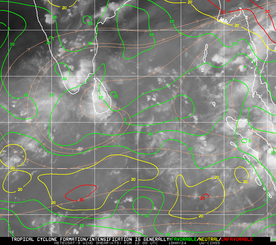
Shear tendency to decrease in the region of low pressure. Will have low shear around 10 knots then.
Will be great if it keeps decreasing along it’s path
madanbabu KarthikStorm
Shear tendency map indicates the predicted shear for the region. In that map blue dotted lines denote regions where shear decreases and bold white lines indicates regions where shear is supposed to increase.
Lower wind shear helps systems organise and form a better circulation.


Not much left of the system. Constant shear has prevented development.
Phailin successor may head towards TN
http://www.thehindubusinessline.com/todays-paper/tp-agri-biz-and-commodity/phailin-successor-may-head-towards-tn/article5249505.ece
According to the wind shear map, system seems to bee moving into relatively low shear now. 5- 10 kts.Hope it shows considerable development today.
Bhaskaran19
Our hope lies here
GFS latest run is good until this point..do not take it forward!as it shows a strong system in arb sea!
http://www.weatheronline.co.uk/cgi-bin/expertcharts?LANG=en&MENU=0000000000&CONT=swas&MODELL=gfs&MODELLTYP=1&BASE=-&VAR=prec&HH=102&ZOOM=0&ARCHIV=0&RES=0&WMO=
System will develop from now. Shear has become very less and is still reducing
IMD Nungambakkam -1 mm 😀
bright chances of rain tomorrow cola and foreca prdicts big tower
karthick, yes.. . Shear going down.. Xpecting a build up slowly.
dark clouds over north moving towards south
Selcyclone
Yeah 🙂
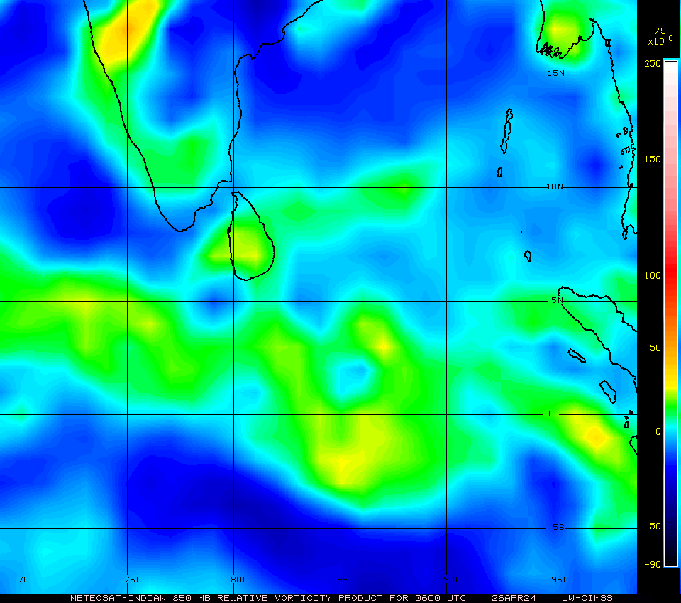
Vorticity is also getting concentrated slightly. So as shear relaxes, good chance of this becoming a depression.
susa
today u have school
any leave for school on monday because of lpa or NEM
Wow as GFS predicting heavy rains Cola meteogram shows
115 mm from 22nd night to 23rd Night in 24 hrs
85 mm from 24th night to 25th Night in 24 hrs
200 mm in 2 days.
First things first…I have been following this blog last two NEM and this year, the entire year. Very educative posts from many of you. Thanks a million to KEA, Sel cyclone, Pradeep John, JupiJove and many others. I wish I could have made it to one of your meetings. Maybe the next one if Iam permitted to.
nshankara you are always welcome.
Wind shear to be lowest near Chennai on 21st. Its less than 20 knots
KarthikStorm Selcyclone
Forecasts point to a well marked low or a DD at max. Hope it stays that way. Cyclones are waste of time,energy,money, lot of destruction. A well marked low or dd that stalls off the coast is a dream rain show. I remember how the depression that very slowly moved up the coast along Chennai in 1996 brought 54 cm of rain in two days in November.
A lot of convection around 10 N. Immediate effect of shear going down. Nice start.
http://www.imd.gov.in/section/satmet/dynamic/insatinddist_vis.htm
http://www.imd.gov.in/section/satmet/dynamic/iso1.htm
This storm if it goes to Gujarat as GFS will not intensify due to high shear and also dry air.
It will fizzle out
paul abraham may be
pj answer my question
any leave for school on monday
ECMWF is taking the Mahesan cyclone which traveled along the east coast from chennai to Bangladesh.
Only difference is it will very close to chennai
Landfall in Bangaladesh / Burma on 28th October. Hope it does not happen. It will again take all the moisture left out. And we will without rains for 3-4 days
paul abraham No chance.
According to ECMWF, the LPA stays close to chennai for 2 days.
COAMPS Sea Surface Temperature
Good condition for Depression to grow along Chennai
Entire Coimbatore district have been battered with heavy rains. Even Ramanathapuram district. Many stations report over 100 mm
nice clouds with dark nice to see
paul abraham it always happens before onset of NEM
Pollachi in Coimbatore records over 100 mm. Mandapam in Ramanathapuram too gets over 100 mm. Lets wait for IMD figures
Goodmrng all
Pradeep I dont think it gonna happen as there is a hpa near myanmar…hw this is possible???
Paul is it raining there or it rained on yesterday night
mitansunshine lst night nungabakkam kea station got 2 mm around midnight…
Thnks sail…by d way wat u think abt d new system
mitan, it wont go there. ECMWF will change it soon. Most probabale is that LPA crossing TN and going as a depression near Kerala
raining in ayanavaram NEM season was nice
paul abraham raining now?
According to latest news death toll has reached to 61 in odisha due to cyclone phailin and can increase more due to severe flood
mitansunshine it should develop as the shear is reducing..key factor is the shear… it may decide on how much rains we could get…
rains are definitely on the cards… question is the amount
mitansunshine link please.
Pj I think d system will b sheared
mitansunshine yes. i already posted that. Wind shear is too high in Arabian coast
light drizzles here
Pj it is according to local newspaper called sambad….u can search e-paper sambad in google bt really sorry u cant understand odia
Sail if a depression forms then it is enough looking d condition as of nw..lets see
sir, why dont u list out regular bloggers with their place
i saw the picture few minutes back system going to andhra and orissa its correct or not see the bbc weather
Interior tamilnadu getting very heavy rain for last five days in Chennai we are nothings .What is the real factor if system forming moves to andhra ,orissa
No one answering my query pease clear my query
share link here
madanbabu
Dont worry. NEM is going to set only. It is not yet set. Once it is set, North tamil nadu or for that matter entire coastal TN will start getting rain more. NEM is actually is a important monsoon for coastal TN from chennai, cuddalore, puducherry, nagapattinam, pudukottai and tuticorin districts (All coastal districts).
The current rain in interior tamil nadu is rains in transition phase from SWM to NEM.
Madanbabu u will get heavy rain once nem sets in…system has less chance of making landfall in odisha and ap…it has more chance to make a landfall in TN coast as there is no hpa near TN coast and the hpa lies near burma
PradeepJohn
Expected has happened. yesterday’s satellite picture told the upcoming story.
madanbabu
Each & Every Model will vary now, the system will go odhisa / west bengal / andhra,….
We can able see this only the system forms & started to move. the image whatever u have seen is the prediction, this will change model to model.
NEM Winds are not stronger, TS / Popups forms in the Sea (Bay) is not entering the land due to weak sea breeze. If its sets we will have rain in chennai.
Regarding Interior TN rains, TS / Popups are formed in the land, so its easily to travel across land this also may the chance over of SWM to NEM, for last 4 days we are having the wind direction as North East to South West.
s_velayudham madanbabu
In generally north east monsoon set in chennai after only its take place to andhra and other state.
selvam13 madanbabu
Imd North east monsoon set on 22-10-2013,Yes system is form in bay of Bengal why its move to Andra and orissa and westbengal model model shoeing like BBC,etc.Please tell me selvam
madanbabu selvam13
I dont know which system u r referrring. As per IMD , a low will only form in 24 hours and it will move west North westwards. We have to wait till any thing formed. Once NEM is set, things will change in no time. So dont worry. We will get our rains for sure. If you see the satellite image, all clouds are moving towards tamil nadu coast only.
It is our monsoon. God given monsoon for the injustice he has done by awarding SWM for regions of india but not Tamil nadu. Otherwise why farway Hightpressure area in siberia is inducing North eastern winds and why it should gather moisture in Andhra coast and pour in tamil nadu.
Its not like that.
NEM is mostly related to (Disturbance in Bay) UAC, LPA, Cyclones,…..
few drops of rain (literally countable no. of drops) here in ekkaduthangal for 2 mins and now back to normal..
mitansunshine
Nice answer ji,but most of the mdels saying to goes to north why what the reason
Chennai all set to receive the monsoon rain – overcast sky – drizzles everywhere
Southwest monsoon is better they give rain to CHENNAI .But still north east moon did not set in Tamilnadu no rain indication.But winds change but no use of these wind.It s not coming always from north east its some times change to west.What is the reason.Interior getting rain for 4 days its south west monsoon rain please explain briefly any one .
madanbabu Already Replied, please request u to don’t make repeated questions
s_velayudham madanbabu
its not repeated question please tell the answers
NEM is always depends on disturbance in bay…
If disturbance occur we will get rain.
Lovely overcast sky
s_velayudham
Thank you sorry for question you are experts so i asking queries.Beacause all the stae are receved eavy rain fall but coastal tamilnadu including chennai not received any rain.Ok North east monsoon not set yet we have pre-Monsoon rain that also not happening.Last four days sunshine bright.tODAY ITS little bit cloudy.
Bhaskaran19
not opening link
Astronomers in Ukraine say a deadly asteroid is likely to collide with the Earth in 2032.
According to a Russian news service, researchers at an observatory in the Crimean Astrophysical Observatory think the space rock – said to be 1,345 feet wide – is on course to hit our planet on August 26, 19 years from now.
satellite pictures shows heavy rain in nagai district,tiruvarur,district,ramnathapuram etc
Madan babu u need to wait forr nem which may set around 22nd and then u will get rain and winds r changing bcoz nem has NT set yet…once it will set wind direction will b permanently blow from ne…as nem has NT set yet TN is getting rain in patcheswise due to local convection and a circulation over TN and srilanka coast…nw hoping all ur doubts r cleared
Heavy drizzles in Chrompet
Bhaskaran19 nothing here
KeerthiVasan Bhaskaran19 After the drizzle sand smell (lovely maNN vasanai)
Bhaskaran19 KeerthiVasan i can able view rain shadows from here
here also no rain
cat5hurricane
only mangadu has chance of rain porur, ramapuram has chance of rain
paul abraham
where which place please mention
Any updates of Low Pressure
@madanbabu @paul abraham
in ayanavaram
Red spot near Tambaram

Partha How is it in Katupakkam now
Madanbabu it will form by tomorrow bt the real concern is the wind shear
PradeepJohn but no rain in east tambaram …..
Mitan where is the wind shear near TN.
PradeepJohn Already heavy drizzles on and off – expecting full fledged rain any time in Chrompet
Shear tendency to decrease in the region of low pressure. Will have low shear around 10 knots then.
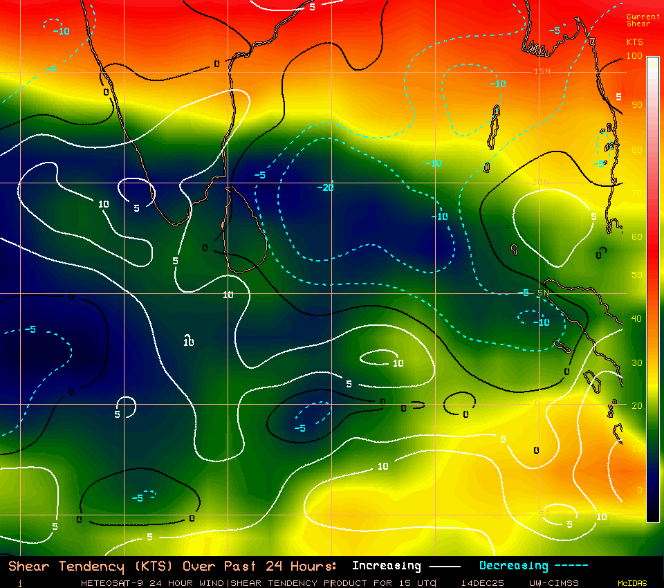
Will be great if it keeps decreasing along it’s path
Where are you Partha please update
Shear is so less near TN.
Bhaskaran19 It dont think it will rain heavy in Chrompet
Bhaskaran19 PradeepJohn according to radar no chance no chance for heavy rain
KarthikStorm
I am not able to understand Shear tendency please explain
Mitan Shear is so less

pj today have a rainy day and tomorrow
KeerthiVasan Bhaskaran19 PradeepJohn -Cloud plays hide and seek game, as of now it is very hot and humid – will wait and watch
wow heavy rain in Annna Nagar West
Big droplets
why east coast areas not get rain ?
madanbabu KarthikStorm
Shear tendency map indicates the predicted shear for the region. In that map blue dotted lines denote regions where shear decreases and bold white lines indicates regions where shear is supposed to increase.
Lower wind shear helps systems organise and form a better circulation.
in guindy sun shine brightly no rain here