
The Monsoon has been active over Uttar Pradesh, Bihar and North Eastern states and it will continue to remain active over those areas in the coming days. Heavy rainfall is expected to occur at most places of Jharkhand, Bihar, Sub-Himalayan West Bengal and North Eastern states. The Rainfall will gradually increase over coastal West Bengal and Odisha from Wednesday, as a new disturbance is expected to develop in the North Bay. There is also a weak disturbance to the south of Srilanka and its adjoining areas which was responsible for the thunderstorm activity over TN for the past few days. The Conditions are not favorable for any further development of this disturbance and so it will remain as a weak feature and move westwards giving rains to South & West TN (including localized heavy spells over Nilgiris and Coimbatore) district and Kerala.
An area of High Pressure will dominate the events in TN by middle of this week. This system will suppress the development of thunderclouds, leading to decrease in rainfall activity over most parts of TN.

Chennai will see max temperature moving closer to 35C.Skies will be partly cloudy with a chance of sporadic showers during evening/night.
Coimbatore will observe max temperature between 32-33C with a chance of thunder showers during evening/night.
Madurai will witness cloudy skies with max temperature touching 34-35C.Thunderstorms are likely to develop during later part of the day.

Gud morning guys.;)
Monsoon 10 p.c. below normal so far thne.ws/1TQ3pQh
Good norning guys past 1 weak dry weather in chidambaram today any possible?
Winds have turned to perfect South and Misty Morning in Chennai
As per NET, Due to Southerly Winds fast Moving low level clouds expected to be around in another one hour
Good morning!!!
Good morning… Wat is the reason for this foggy morning in chennai
UAC?
No…
enna jii ipdi intha UAC yum epdi paniduche?>
Yes it spoiled our regular rainy days….
yes yes.. from tmrw chances are there as per rao sir.
Hybrid electric vs ts – 100 mm in some places…..yeah I remember
Always ESE and Southerly winds brings misty morning. In NEM period during break we might see the same type of Todays Weather
Another UAC History Continues…
Good morning..Don’t blame God for not showering you with gifts. He gives you the gift of a new day with every single morning.
Chennai city may have trace to light rain and no significant change for another couple of days.
Some parts of North interior and western interior districts including Erode, Salem, Dharmapuri , Tirupur will have moderate rain today .
Good morning
As expected fast moving low clouds arrived from South
Expecting rains on Friday and Saturday.
No suprise yesterday’s rain never materialised. UAC’S are really useless
proper orientation of UAC is important.
Winds from SE has dry air merged with outer band of ACC over BOB. Thats the Reason for No Rains today Morning and there isn’t proper flow of SE winds at lower levels. Mid levels from SE and Lower Level winds from South
This UAC had at least benefited the interiors.
Interior Tamilnadu will get Good Rains Today Coastal Tamilnadu especially North will have Dry Weather with some Cloudiness Present in the Atmosphere
The UAC had moved west, no more heavy rains for the interiors.
will the convection be driven along SW/W-coast of India??
Most of the convection associated with this UAC is occuring in the sea.
Interiors will see TS as the winds are from South especially South Tamilnadu
Flash…fresh MISO alert (by next week or so..)….as MJO will be entering at phases 3 (may travel towards 4&5) by next week onwards. So exactly fresh MISO will be initiated to ignite much needed SWM-LPA/depression over WC/NW-BOB.
This LPA/depression will travel along central India to pound central, peninsular and west-central and east-central India will record much needed heavy rains. This rain-wave will be comparable with June 3rd week rainfall scenario.
Mumbai and suburbs & Konkan and Goa will get exceptionally heavy rains during this period.
Yea finally mumbai will end this swm in normal.;)
any doubts for anyone?? 🙂 I won’t be surprised if Mumbai ends in excess before SWM-ends 🙂
No doubts for me;)
oh..then you are more aware of strong bond between SWM & Mumbai 🙂
7.30 am visible satellite
UAC-convection will reach Indian W/SW-Coast or not??
http://www.weatheronline.co.uk/weather/satellite/Asia/India/Infraredcolor.htm
GFS is predicting a low from this UAC, in the Arabian sea!
Currently the winds are not in favor of the SW coast.
OMG..then 😦
It’s only going to be short lived.
so there will be high chances for its convection/related moisture to merge with SWM-winds under strong pull effect of WP-typhoon sisters.
Thunderstorms will occur in interior TN today.
wow..then SW/W coast will be pounded with heavy rains 🙂
Mostly interior Kerala would get pounded!
Tat 75-77E longitude may see good action.. Madurai,theni,dindugal,tiruchi,karur,salem and districts bordering kerala state hav good chance for ts activity…one place among theni,madurai,dindugal &kodai may see historic rains
I hope nobody asks if it will rain today
will it rain today ? ? ?
can we expect some rain today
hereafter we have to ask – will cloud formation happen for Chennai ? ? ?
Good Morning All,
This is the day going to be hotter, this southerly winds not going to reduce the heat.
Looks like it’s going to be a hot day today, but many are expecting it to be a pleasant day today. Let’s see..
It’s already 31.3!
What temp Max do you expect?
Wait and watch for today ts
Are you awake or still dreaming?
Loll . Wait and watch
Yea looks like that only.
OMG
My comment Featured for the First Time 🙂
See how the Dry Air Impacted us
This is what i was mentioning yesterday. I saw this dry air occupying for 2 days since yesterday.
This is why i was saying it will not rain.
Spot on Prediction Partha
was it affecting us yesterday?
Yes, the above image is early morning 5am
5am? not tday right?,
Today mrng 5am
Selva,
Yes it was affecting us, i posted an image yesterday afternoon.
Saw this to affect for next 2 days since yesterday.
how far it affected? i mean from the coastal line?
it was affecting us close to coast line of TN and SAP.
why i am asking is bcos yesterday we had a decent intensity ts 30 to 40km inland along the VDP hills..sometimes conditions changes abruptly after proper heating…mainly wind direction didnt favoured us
Yes, this is what i was mentioning, it was not a regular SWM day, it was dominated by UAC, influenced by ER. Hence the conditions will not change abruptly.
Partha i accept defeat….we are equal now.
I have not defeated you PJ, I just said on what i was seeing.
I was never into a bet with you, then how can you lose.
🙂
Is partha in Aug or sep team
If this is a normal year I would have opted September, since ELNINO i have opted August.
not equal. partha 2-0
last time he said no rains till August 6. It rained. I know the score.
may be some other bet, i never said it wont rain till 06th august.
see the link below, the forecast i gave 21 days ago for 31st to 04th.
https://disqus.com/home/discussion/keaweatherchennai/strengthening_systems_coaxing_the_monsoon_to_flare_up_over_east_india/#comment-2160687222
Good morning, Very humid day today,
If this system strengthens and moves north, there will be rains in Chennai.
There is no if and but in weather
are you sure?
100%
so you mean models are 100% correct?
Selva,
That ACC over Andaman has formed due to fill the gap between 2 CC.
First CC in South of Lanka and the Second one in West Pacific, the strong system. These 2 CC’s has created a space in South China Sea to West Central and Adjoining South West Bay of Bengal. As we know if there is space in atmosphere then it will be occupied by ACC.
See the link below of yesterday night. From WP to Bay.
http://earth.nullschool.net/#2015/08/17/1500Z/wind/isobaric/700hPa/overlay=relative_humidity/orthographic=-259.46,12.18,1175
tat suppressing hpa is associated with ER wave
Yes, this also i mentioned in mail which i sent to Ehsan on 11th.
Why did I say that STN will be mostly benefitted from 16th onwards. Whatever the rainfall the NTN, SAP and SI KTK have got was due to this suppressed ER Wave and ACC created ridge at mid level upto Coastal TN and South Coastal AP. The dry air was staying upto coastal area and interior got moist air, this has bought them TS.
partha,it isn’t necessary for the inactive region of the atmosphere to get occupied by the hpa.. The wave which we are talking about is naturally aligned such tat a low gets followed by a high pressure area..this pressure alignment varies with different waves
agree, but i was talking about the present one, not for every time.
East looking dark
current pic of Tiruvannamalai
Strong atmospheric CCKW pushing over MDR now- giving life and shelter to 96L.
What r these coded words? i don’t understand anything
kelvin waves…
Temp may not so high.
But it will be a very warm and uncomfortable day
Agree with you
Rains due to ‘ veppa salanam’. – TV news
until the system becomes cyclone TV news will say its due to veppa salanam.
Hmmmm
Lol….even this can be…..
Puyal karanamaga tamizhagathil Veppa salanam mazhai peiyum..
IMD has mentioned in yesterdays report that UAC has formed In SW Bay
they r right.. it never rained day and night like how we see during system..
Yeah indeed. Storms formed around noon and rains are only in evening/night over Tamilnadu
The UAC itself forms due to veppa salanam!
“The rainfall shortage is about 10% as of now. The deficit is expected to widen further to 12% by the end of the season,” Laxman Singh Rathore, Director-General of the Indian Meteorological Department (IMD) said.
http://www.dnaindia.com/money/report-monsoon-deficit-to-widen-to-12-impact-kharif-crop-says-imd-2115406
What if 12%?
raising the fear of drought for the first time in 6 years
I thought we escaped from the worst.
SWM rains are mostly predictable by models.. but when it comes to NE monsoon. They fail a lot. 🙂
ER Wave Suppressing the area of South China Sea, Andamans and upto Coastal TN.
http://www.atmos.albany.edu/student/macritch/showhoriz.php
when will chennai get rain partha ji
from 20th the UAC will go off completely.
either from 21st or on 22nd we have a chance for TS.
According to preliminary data from NASA along with information from the Japan Meteorological Administration, July 2015 was the warmest month on record since instrument temperature records began in the late 1800s.
Research using other data, such as tree rings, ice cores and coral formations in the ocean, have shown that the Earth is now the warmest it has been since at least 4,000 years ago.
According to NASA’s data, which is subject to refinement in coming weeks and months as more is analyzed, July 2015’s average temperature nudged past July 2011 by 0.02 degrees Celsius, or .36 degrees Fahrenheit.
Every month this year has ranked in the top four warmest months, according to NASA’s data.
http://mashable.com/2015/08/17/july-hottest-month-on-earth/
When will wp systems will start affect our basin?
Y this dark cloudy patches howering like nem
Nothing surprise its usual Phenomenon of Southerly Winds
Watch out the direction, it’s not NEM like.
Conditions will be restored to normal SWM days from 20th.
TS chances for Chennai from 20th. especially 21st or 22nd we have bright chance.
Trough likely to dip due to an UAC formation over North Bay.
This Day In Weather History
Mississippi Coast Virginia (1969)
Hurricane Camille blasts onshore just west of Pass Christian with a 24-foot storm surge. Wind gusts peaked at 175 mph in Gulfport, MS. 256 lives were claimed, and $1.3 billion in damage done. Camille weakened and proceeded to move into Virginia, dumping 2 feet of rain and causing terrible flooding. 113 of the 256 lives lost were due to the Virginia flash floods.
Haiti (1929)
Haiti leveled by hurricane along with an earthquake and tidal waves.
Mankato, MN (1946)
27 ton road grader thrown 100 feet by F4 tornado (wind 250 mph).
POAMA latest long range outlook is out and now they’re expecting strong el nino in coming months similar to 1957 event( peak around +2.2). Their earlier forecast was showing super el nino similar to 1997 event( peak around +2.5). Also they expect moderate to strong positive IOD during NEM. Their earlier forecast was showing neutral IOD during NEM.
JAMSTEC was the first model which showed 1957 like elnino in coming months and now POAMA agrees with it.
Going by the above forecast, Chennai will get good rains from regular easterlies and we can expect less number of systems during NEM.
http://www.bom.gov.au/climate/poama2.4/poama.shtml
even Poama was expecting Positive IOD since June.
how are you saying POAMA reliable?
Moody’s Investors Service cut its forecast for India’s
economic growth to around 7 per cent this fiscal year (2015-16) from
7.5 per cent because of lower-than-expected rainfall in the ongoing
monsoon season, the ratings agency said on Tuesday-ndtv
but it is not a surprise. How can they say lower than expected rainfall? IMD has been warning from day 1
one month back, imd says its above normal. they are changing monthlywise. now moody concluded its below normal
when did they say?
thedanum
I never saw a forecast like this in IMD page since May. They have even reduced the percentage in 2nd half forecast made in July.
since mid may they are saying drought. Never changed
IMD never told that above Normal SWM, they are telling deficit SWM from the beginning
UAC is an useless system and not even drizzling. in fact it also impacts evening thundershowers. however today afternoon thundershowers will be back as we notice westerly winds picked up well.
ss
westerly winds will not pick up until 20th.
UAC is not useless did Chennai doesn’t seen any rains from UAC?
South Chennai received around 40mm from this UAC
Mature El Niño in the tropical Pacific region
update from BOM
Average of international model outlooks for NINO3.4
August team middle order is collapsing, it’s up to the tailenders to finish the business!
Sept team don’t have any batsman…. (all are tailenders)
pitch has become a minefield. Impossible to bat
then abandon the competition, let us concentrate on NEM
The Southern Oscillation Index (SOI) has remained relatively steady over the past two weeks, at a value slightly more negative than two weeks ago. The 30-day SOI value to 16 August was −20.3.
Sustained positive values of the SOI above +7 may indicate La Niña, while sustained negative values below −7 may indicate El Niño. Values of between about +7 and −7 generally indicate neutral conditions.
Hi Vela which software u use to construct these charts ? it is good
the charts are from BOM (Australian Meteorology)
Web Site Link – http://www.bom.gov.au/climate/enso/
New features: atmospheric chemistry from NASA’s GEOS-5 model, updated every three hours:
Carbon Monoxide Surface Concentration
Sulfur Dioxide Surface Mass
http://earth.nullschool.net/#current/chem/surface/level/anim=off/overlay=so2smass/orthographic=80.27,13.08,369
Indian Ocean Dipole (IOD) outlook
September – http://www.bom.gov.au/climate/ahead/models/iod_summary_2.png
November – http://www.bom.gov.au/climate/ahead/models/iod_summary_4.png
January – http://www.bom.gov.au/climate/ahead/models/iod_summary_6.png
Thunderstorms gave good rainfall yesterday in various places
Medapalle – 100 mm
Kotapadu – 91 mm
yellanki – 85 mm
chityakala – 85 mm
Ravikamantham – 84 mm
Palamaner – 81 mm
Govindaravpeata – 80 mm
Gumpulathirumalagiri – 80 mm
Mallempallu – 80 mm
Found an interesting site online. Hope their forecasts turn out to be true
https://www.meteoblue.com
It is matching with my forecast…
yes added a widget too on the right. Looks really nice
Thanks Kea
Looks like a Summer’s day here in Bangalore. Very warm now!
Massive thunderstorms developing in Telangana and east karnataka….typical april may type climate
April and may u guys burned with 43-44 c
Poor guys
http://www.jma.go.jp/en/gms/largec.html?area=6&element=1&mode=UTC
POAMA v2.4 model winter fcst:
Both BOM and ECMWF showing typical nino pattern during NEM. STN and SL will get excess rainfall. NTN and SAP may get normal rainfall.
did u see NMME OUTLOOK?
Yes.
it was showing drought like scenario for north and central parts of TN
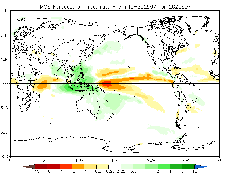
Yes NMME( North American multi models) is not good. IMME ( International multi models ensemble) is better than NMME.
not good? they r avg of all top 5 U.S MODELS ..CFSV1,V2,NCEP, NCAR,CMC AND NASA
They all based on GFS( US). IMME considers other weather agencies models such as ECMWF, APEC, UKMET.
yeah i know but ,ECMWF forecast was not encouraging.
OND forecast
tis is okay.. chennai seeing normal rainfall
Can you please tell me about 1918 BOB cyclone season.
early oct system moved northeast as depression,weak tropical storm hav made lf between MADRAS-PONDI around 9th/10th of nov.. another mid nov system formed near lanka and moved north before dissipating.. dec cyclonic system formed in s.bay and dissipated before making LF in w.bay
Thanks.
What about NEM. Was it normal or above normal for TN.
486mm..normal category
One interesting thing happened in 1918. Chennai got excess rainfall during NEM. It got 1275 mm whereas TN got normal rainfall.
not depending only on GFS ..all individual forecast
i checked all their performances ,they r OK in predicting
why dec alone? what about OND?
Good news for September team. GFS picking up WML/Depression in WC BOB around 2nd September.
http://www.weatheronline.co.uk/cgi-bin/expertcharts?LANG=en&MENU=0000000000&CONT=swas&MODELL=gfs&MODELLTYP=1&BASE=-&VAR=prec&HH=360&ZOOM=0&ARCHIV=0&RES=0&WMO=&PERIOD=
September team is already disintegrated.
August lead is already humongous and with weekend rains the total will double.
even IMD expecting strong revival of SWM in September.
Spot on
so u r missing the train?
Yes…I’m depressed
Strong MISO on the cards
September team na summa wa:-)
Clouds moving east to west in Bangalore?
Flash…fresh MISO alert (by last week or so..)….as MJO will be entering at phases 3 (may travel towards 4&5) by last week onwards. So exactly fresh MISO will be initiated to ignite much needed SWM-LPA/depression over WC/NW-BOB.
This LPA/depression will travel along central India to pound central, peninsular and west-central and east-central India will record much needed heavy rains. This rain-wave will be comparable with June 3rd week rainfall scenario.
Mumbai and suburbs & Konkan and Goa will get exceptionally heavy rains during this period.
What about IOD forecast.
That is too much of expectation.
Rainfall possible from 20th over West Coast until 25th, from 25th Kerala and KTK coast will get good rainfall. However dont expect too much like excess rainfall. MJO not going to be strong.
MJo going to enter phase 2 in coming week and will also gain intensity( amplitude >1) in phase 2.
http://mikeventrice.weebly.com/mjo.html
That forecast i am watching for the past few days, dont rely for more than 4 days, it will change again i feel.
but this time both ECMWF and GFS expects mjo to travel towards phase 2,3 in coming week. Click on the image to see the latest.
This is the second half outlook for SWM from IMD, released on 03rd August.
The rainfall for August and September to be 84%.
Click to access LRF_second.pdf
but IMD long range forecast leading scientist Dr. S Pai expecting large scale revival of SWM in September.
how much revival?
the deficit far deeper, even it revives SWM will end in deficit only.
He just told that expecting large scale revival of SWM in September. During September SWM mostly confined to Central and peninsular India.
no ,he said possiblity of rainwave picking up by late aug after w.pacif typhoons making lf.. not in particular for sep
Oh Ok.
Big time MJO likely from 15th September, this will become very very huge one and sustain until end of the month.
So excess rainfall for peninsular INdia in September.
This is what I was saying from last few weeks. We will get awesome rains in September.
but there cannot be chance that Chennai should get abnormal rainfall during MJO in SWM.
have to check the history.
Observation,
October first week system confirmed, it might cross North AP to Odisha coast.
😦 again bad luck for TN
no need to panic. NEM expected only after 15th Oct
Then ok…
Partha what abt today
rain only after 19th. Today no chance of rain. He has already said the same.
Oh… god every day we are suffering Varuna Baghavan Karunai Katta mattaro….
why getting worried? Both Nunga and meena has received excess rainfall upto now this SWM
still water scarcity is very high in chrompet
We need to wait until Oct end for water situation to stabilise.
already said today morning, until 21st we need to wait.
Nothing gets confirmed when it comes to weather forecasting!
shall we have a bet?
Yes, tell me the date when the first October system will form.
the date is very tough now itself, this is why i said first week.
Bet is valid for exact dates only!
Again? Source?
that is secret…
Tell me that secret and delete it pls
Strong or weak system.
cyclone.
cat1 and above ?
cyclone going to Orissa so early in NEm is bad news for Chennai. Am I not right?
no, are we getting NEM by first week of October?
this is like Phailin which we got in the 2nd week of October 2013.
Pre NEM cyclones are the one’s which will make the situation conducive for NEM onset.
No it might even derail
We don’t get strong systems during strong el ninos, positive iod and westerly phase of QBO. So we may get CS/DD during SO period, not cyclone phailin like systems.
Source please
no i will not share partner, wait for things to happen.
Ok then WhatsApp me
I want to learn
will surely teach you, i am also learning based on this forecast.
Btw is it a model?
nope, no model, no precipitation chart, it is something different.
ER wave chart?
Current IOD and QBO values exactly matching 1918 iod and qbo values. Even current el nino showing similar trend to 1918 event.
Chennai got excess rainfall during NEM in 1918. It got 1275mm during NEM.
TN got normal NEM. It was around 486mm.
Tiny TS pops in far South east of Chennai.
Ehsan,
The first week system is good enough to make the onset of NEM.
I am hoping that NEM onset might be before 15th October.
Give me a weeks time, i will surely confirm the period.
Is it gonna rain this weekend???
IOD values 1918
1918 8 0.270121
1918 9 0.434861
1918 10 0.581363
1918 11 0.497757
1918 12 0.31195
QBO values 1918
showed stable values around +10 during NEM.
As per forecast, IOD will be similar to 1918 values during coming NEM.
QBO will show stable trend around +10 during coming NEM.
None of the models show a cyclone hitting north ap this October, not even CFS
It’s PFS forecast!
From August 21st to 24th – TS expected in Chennai
From August 28th to 31st – Chennai will see some massive TS rains.
So august tailendress will do the job for the team.;)
But then also they will not be able to save the match:-) lol
Good .Expecting the same to happen
on Thursday night Foreca, shows huge tower for Chennai.
http://www.foreca.com/India/State_of_Tamil_Nadu/Chennai
Last 5 days rainfall of cherrapunji
18 August – 313 mm
17 August – 162 mm
16 August – 195 mm
15 August – 191 mm
14 August – 102 mm
Total past 5 days rainfall – 963 mm
Total Rainfall from january 1 till now – 8701 mm
Wow .Super
perfect conditions for thunderstorm by late evening or night. typical august/september weather. the useless UAC shifted to west. towards arabian sea.
ss
Dont think any rains today.. will be simply hot , dry and calm night weather..
nobody is expecting rains either
Near Sriperumbudur just now
POPUP’s likely in few minutes from now over NTN. It will be on the interiors, this POPUP will move inland from East to West direction like yesterday.
Interiors have good chance for TS today.
Bangalore 1.45pm, Clear skies,bright sunshine., mild breeze, and few cumulus clouds here and there…
u have a chance for TS today, just wait.
Twin explosion over west

sel i was seeing this and asking mouli. How can there explosion when there is HPA.
Can anyone identify this storm in Bay.
1999 Odisha super cyclone.
nope…
easy one Phailin 2013
Tropical activity in the Pacific Ocean
– Typhoon Atsani likely to intensify throughout the week as it heads northwest of Guam
– Typhoon Goni to weaken slightly throughout the coming week
Madden–Julian Oscillation (MJO) remains weak
– No significant influence on tropical weather last week.
– MJO likely to remain weak in the coming week.
Mature El Niño in the tropical Pacific region
– Latest weekly NINO3.4 sea surface temperature anomaly is very high (+1.8 °C)
– El Niño likely to warm further and persist into 2016
Cherrapunji monthly rain of 2015
January – 17.7 mm
February – 29.4 mm
March – 33.4 mm
April – 616.2 mm
May – 1212.8 mm
June – 4355.5 mm
July – 1263.2 mm
August – 1172.8 mm (Till August 18)
Partha, You only told that I had done lot of research on MJventrice link. Then how are you missing the good amplitude of MJO at phases 2&3 (even I am expecting it to enter phase 4). If this happens exactly June-2015 3rd week’s type systems (either at BOB & NE-Arabian) will take place. But by keeping in mind the southward shift in SWM-axis, Rainfall going to blast East-central, Central, peninisular, and west-central (Mumbai, Konkan & Goa). I am also aware of the fact that MJO won’t attain greater than 1 amplitude in strong elnino years. But some how elnino-2015 exhibiting different colours, by which elnino-2015 becoming a good piece for young researchers just like 1997-elnino. MJO-OLR: http://mikeventrice.weebly.com/mjo.html MJO: http://www.cpc.ncep.noaa.gov/products/precip/CWlink/MJO/CLIVAR/ALL_emean_phase_full.gif
the foot note i gave on that day was, not to believe beyond 4 days.
MJO playing lots of hide and seek this time of the year, during ELNINO it is tough to predict it.
Also don’t just take the forecast from CPC for MJO.
Which MJO-model will be good? Both ECMWF & GFS indicating MJO to enter at the interface of phase 2&3 or directly phase 3. At that time it looks there won’t be any ER-wave also at these phases. So stage clearly setting for MJO’s entry at Indian Ocean.
I never said it will not emerge into Phase 2. However i said we need to wait for 2 more days at least to get some clarity.
I would still go with MJ Ventrice for sure. Short term forecast is the best method to track MJO.
Yes. But day by day MJO forecast becoming firm and interestingly MJO-amplitude increasing at IO in the forecasts. It’s really worth watching.
i am observing this for the past few days, but interestingly massive change in the forecast. It was initially pinpointing towards Phase 7, now taken to Phase 2, this is why i said need to wait for 2 more days.
we have possibility of MJO this time
No Partha, both GFS & ECMWF are very firm for MJO to enter IO consistently for the past few days most of the time except 1 or 2 days (I am also watching regularly).
@guest11k:disqus
I accept your point…. only small change
North TN will record / register above Normal Rainfall
Central TN and South TN will record / register Excess Rainfall
Why can’t be reversed by keeping nature’s balancing act in mind Vela??
This year iod and qbo values mimicking 1918 values.
Oh.. it’s good. I already read your previous comment of excess NEM in 1918. What about BOB-cyclones season in 1918?
early oct system moved northeast as depression,weak tropical storm hav made landfall between MADRAS-PONDI around 9th/10th of nov.. another mid nov system formed near lanka and moved north before dissipating.. dec cyclonic system formed in s.bay and dissipated before making LF in w.bay
Courtesy: Sel
So quite active but not strong. If the systems are dying near TN Coast, then they will dump heavy rains. Hope NEM-2015 be like that 1918 (instead of stronger systems).
I can’t interpret the Nature’s Balancing ACT, BUT it has its own… balancing ACT
PJ,
The HPA is till the coastline only, not over the interiors, may be not beyond 30-40 KM approx.
OLR tell differently Partha. See radiation is high in interior than in sea.
Can anyone identify this storm in Bay?
Mala ?
Sidr
U r right!!
Rainiest days of cherrapunji with above 200 mm in 2015
June 8 – 579 mm
June 1 – 542 mm
June 10 – 515 mm
June 6 – 410 mm
June 9 – 404 mm
June 7 – 340 mm
August 18 – 313 mm
July 24 – 259 mm
June 13 – 255 mm
June 24 – 200 mm
Can cherrapunji beat 24 hour rainfall record of 2014 atleast ??
Cherrapunji 2014 record is 776 mm on july 7
on sunday Mawsyanaram 409 mm yesterday 198 mm and today ?
PJ…Can u post mawsyanarum rainfall figures of 2015…Iam not able to find them on regular basis
not having them. Will get it from IMD
Waiting to see Mawsyanarum rainfall figures
PJ,
Here you go the OLR latest update.
Parrha..I think you are going in line with 2013 14..also relatively el nino years.. so cyclones may hit the same place right am I right with my gues
I am not going in that way. Unconfirmed ELNINO and Firm ELNINO is totally different.
SST differs, SST from zone to zone differs, Anomaly will vary, atmospheric conditions will vary. You cannot relate 2015 with 2014 for sure.
September Team. GFS picks up the CFS system in 1st few days of September.
PJ
Better we wait till OCT….
Yes, we can wait for TN-systems till October. But CFS telling about AP/Orissa SWM-system.
not us.you can wait
I feel we all have to wait till OCT. . . .
Oh..no..Vela. September team must win. By the way which team you belongs to?
OCTOBER 2015 – Team
Wango Wango:-)
2014 annual rainfall data for cherrapunjee Stands at 10235.4
I hope 2015 rainfall may be higher than 13000 mm which is 20 percent excess
Super performance of cherra in strong Elnino year
Mawsyanarum might have received 20 percent
more rain than cherra..
proud to have these places in India
This year mt waialeale performance is worst
As per Parthasri earlier post, strong mjo will be present in IO around mid September.
tea cancel
yes rao
If anyone expecting SWM-deficit for Mumabai? If so what could be the reason??
September going to pound heavy rain
Mumbai rarely has deficit
How it will rain in cherrapunji and the rain rate per hr
Cherra aa….there no 46 degrees in summer…no hail storms also.no dum biriyani also.
Hyderabad receiving rains so no plans to shift to cherra
I love extreme temperatures in Hyderabad especially 46 degrees in summer and 6 degrees in winter
September Team,
Strongest MJO likely by 18th September, this will last until month end.
But don’t expect too much for Chennai from this MJO. Only ER wave can bring TS for Chennai
This MJO will strengthen only in Phase 3, some parts of East India will get some rainfall activity.
When this MJO enters Phase 4 or MTC after 26th, a system likely to form over North Andaman Sea and move towards North Ap or Odisha coast. This system will form by 30th September as a LOW and strengthen by 02nd October.
what are the chances for Rayalaseema NI Karnataka and Telangana in september..
NI KTK and Telengana, I am sure they will get near to normal rainfall. Rayalaseema is doubtful.
But at present NIK is more deficit than Rayalaseema…Raichur gulbarga are 65 percent below normal
I disagree with tat point only ER wave brings ts for Chennai.. all the convective phase of these waves enhance lower level and upper level conditions..