
The Indian Monsoon rains looks like heading for a break over the next few days. The rainfall activity will decline in the core Monsoon regions and would shift gradually towards the Himalayan foothills. Currently, several upper air cyclonic circulations are evident well above the surface filling up the air aloft the Indian subcontinent and waters surrounding as well. These systems could bring in cloudy weather with scattered moderate rains. Decent magnitude monsoon rains are to be confined to the western Himalayan states of Himachal Pradesh, Uttarakhand and parts of Jammu and Kashmir. Meanwhile, scattered rains possible across north and adjoining coastal TN.

Chennai to remain cloudy with maximum temperature settling close to 36-37 C. There is a slight chance of rains towards the later part of day.
Coimbatore to remain cloudy with maximum temperature settling close to 30-31 C.
Madurai to remain hot and sunny with a day time maximum temperature peaking close to 37-38 C.

Woow aweasome amounts of rain !!!!
Gud morning guys .
Hope we get to see this amount of rainfall in NEM-2015 in a 24-hour period.
Kalai Vanakkam..utrar uravinar sandror nanbargal ellorukum… Why does the blog fire up only if there’s rain (>.0000001 mm lol)..celebrate every weather event haha…
Bangalore is full of stagnant water..not able to go for morning walk..half the city is badly coughing owing to sudden climatic change..
Meanwhile..saw on Live Mint, NEM will be ~105-125% above normal. Not sure what that means in actual terms.
Lol. We wil be happy if its 100% normal.. no need of 100% above normal..
Afraid of accompanying problems like breakdown in infra mosquitoes and all? lol
Not at all.. afraid of another failure.. that wil make it 4 in a row
Weather is not in our hands..we need solutions to problems and not problems as a solution. Efficient management of water resources/ efficient usage of existing desalination plants/ improving storm water drains will be enough to tackle rains (and lack of rains)..
Lol climate change…..:D
It is not unusual..we regularly used to go to the beach to see typhoons, initially we thought we were the only crazy guys, but there are so many in Taiwan who watch typhoons. Once it rained ~900 mm over 2 days in Hsinchu and Yangmingshan..we as usual went to the beach via metro train..umbrella was shredded like kaima..still we loved it..
Have you been to Antarctica ?
Never..been to Punta Arenas and Ushuaia though..Taiwan coz I worked for HTC mobiles..
Today’s Forecast
Like yesterday, today South of Chennai will have Rain from Tambaram to pondy
Chennai and its coastal will have light TS at isolated places…
So from now on..we have to wait for the retreating monsoon..and occasional heavy TS’..
Retreating monsoon is nothing but NEM
Yes..wistfully thinking..will it pour at all odd hours in Chennai as in olden days..or not..or simply be satisfied with these one-off cloudbursts which don’t do much to alleviate water woes..simply a morale booster..
Good morning!!
have a nice day!!
A very good morning and hope you enjoy the weekend..Thank God it’s Friday will soon become Oh God it’s Monday!!
It’s Saturday
How is the weather in Chicago?
Who is in Chicago?
Weatherbug!
No way. He is in bangalore
Returning this fall..hire 2 more team members and I’m off! Btw weather in Chicago is rainy..flu season there..family down with ear infection..
you are in chicago? i am next to your house just 10min away
by the Indian Institute of Tropical Meteorology (IITM), after staying active for one or two days over central India, monsoon to weaken over the entire country for next 15 to 20 days.
The Pune-based research institute has been issuing the extended range forecast for next 20 to 25 days from last few years on experimental basis. The current forecast based on the initial conditions of August 4 says, “A fresh spell of good rainfall will propagate from Indian ocean to Southern Peninsula around August 20 and central India around August 25.
A break in rains will be useful for crops in north and central India, which have received excess rainfall. But for the southern peninsula, weakening of monsoon for 15 to 20 days does not augur well as large parts in this region have already received deficient rains. States like Maharashtra is going to spend Rs 27 crore on cloud seeding with the hopes of getting some rains in the parched lands of Marathwada, where rains are required for drinking water and growing fodder crops as also for the next rabi season.
Warm day with possibility of Thunderstorms over South of Chennai. Chennai will have isolated Rians towards Evening/Night with Max Temp Expected to be around 36’C.
Madurai, Trichy, Palayamkottai could see a hot day with temp reaching 38 – 40’C
It would be awesome if Australia’s coach gave this speech to the cricket team “Broadly speaking, you were like a kid lost in the Wood; fish struggling without its Finn. This is a warning Bell to us. We have to find the Root cause to this problem and Cook up a solution”
-FB
Any takers?
talkers???
Refresh
Why are they listed for sale in the UK?
They have to carry back extra luggage
That’s Chennai’s annual rainfall!
Chennai’s annual rainfall is 117cm?
Lowest in top 100 rainfall station is 23cm today… Still more rainfall ahead
rain filled system
Whenever Typhoon hits Taiwan, they easily gets 20cm or more especially North East Taiwan known for extremely huge rainfall over 1000mm
No 140 cm !!!
Close Jeet, for comparison.
One of the bestestest animating weather site i hav ever seen.. site may take some time to load but believe me its so cool and highly worthy
http://www.nnvl.noaa.gov/weatherview/index.html
Do they predict rain???
yes of course.. NOAA product so obviously gfs data
Why is it showing lights over India when it’s day there?
disable tat day and night feature
Looks cool, but nullschool is better I guess, more detailed!
null school or windyty wont show the sw winds getting disturbed near ghat areas.tis one shows tat in a very detailed way
You mean the 850 hpa winds?
925 and surface winds!!
Yeah, only the surface winds are getting blocked by the western ghats in nullschool.
How did you manage to open it? Even with 40 mbps it doesn’t open in mobile
Took a while to open!
aircel 3g here!!!
Bro, this is loading too slow!
yes..may be the model resolution is too high and sensitive
What is max speed in 3g? Is it 3 mbps?
vary from 3 to 5MBPS
Extremely slow… Not loading at all for me here in 100mbps
Same here, hope sel posts its screen shot
allowing us to see the hourly variation is one of the striking feature
Sel not opening after 30 mins in my 4 mbps connection.
bad luck ..try reloading pj
Seems only u have good luck 😛
oh no.. its not loading for me now :p
😀 : D
it’s loading for me in ACT at 20 mbps it is similar to earthnull and showing temp etc.!!!
good model !!!
Selvan has some special phone… I think It’s the power of Zenphone that loads this site even in low speed
i am thru system.. tethered to pc thru mobile
Lol!
it opens only on slow connections.
Rajesh 1000 mbps – very slow
Raijin 100 mpbs – failure
Me 40 mbps – failure
PJ 4 mbps – failure
Selvan 3g – success
Vela can u try in 2g?
I am only in 125 Mbps!
Loads very fast and beautifully https://uploads.disquscdn.com/images/53945da4cabc7cfedd8e1b2ffa9d11ea37730281ac8795e855dae8e45edff8a6.jpg
your desktop time shows indias time. Are you in chicago?
Going back this fall..setting up the team here
which team?
Ppl who’ll be reporting into me..lucky !!@#$%s.. they’ll have the bestest and laziest manager..
They should learn some software development from the nullschool team!
After seeing the real time track of WP-super typhoon Soudelor, I redrawn its track by considering the total influence of convergence and divergence bands. This new DILF drawn at the center point of between total convergence and divergence bands (green lines), from there final corrected track was drawn which closely matching with real time track.
earlier track (figure 1) : http://s16.postimg.org/hov9gacvp/wgmsir_4.gif
corrected Sodelor’s track (figure 2) : http://s10.postimg.org/433jt6bg9/corrected_soudelor.gif
Yesterday night part of intense TS marched into 50 kms and went to Pulicat at last minute eventhough winds were NW. Today again Intense TS will march towards the last circle in radar….Lets see how it behaves.
Dengue fever cases increasing in Telangana.
Any floods there??
Vellam vandha mattumthan Dengue-va? It is a man-made disease caused by our glaring inadequacy to drain out stagnant fresh water.
TN gov’t tried an innovative scheme by introducing wild mosquitoes which feast on Aedes Egyptii (Dengue) but the morons at King Institute rejected it saying it will “upset” the natural balance and we ALSO need Dengue mosquitoes to maintain balance. Weird thinking…
Yes u r right bug
The same reporting many places in Chennai also
South Andhra-AP/TN border has got smashed by heavy rains!
Sullurpetta..infamous place..
Tada is famous falls is there
Ha ha ha..you were thinking vegetarian, I was thinking Non-Veg
Manual Rain Gauge at 525 Rs
http://www.ebay.in/itm/Rain-Gauge-/281760689570?hash=item419a3eeda2
I suggest you postpone the purchase to May/June, you will even get it for Rs 25.
Lol International Site!
How Will They Change Rate?
Fixed Price? Namma Roadu Kadai ya Iruntha 25 rupa ku kudupan !!!
Thambi..sutterikara veyila evanavadhu RG vanguvana..adhan sonnen..
Today 36-37 c sure shot… Hope No disappoinment in temperature today
Any Rain possible?
Yes…yesterday it was miss.. Today chances there
Last two day we are un lucky
Better to get used to it for next few weeks
Your optimism is infectious..gotta love ur optimistic pessimism..btw pessimists live a lot longer than optimists- scientifically proven
Weatherbug challenges 38 c !!! in Aug
Poor weather bug
Oh I thought weatherbug is some forecast model
Lol
Of course I am poor and poverty stricken. Give me 5 Rs for a tea, porai and beedi please.
You forgot, you are in Illinois
Ok give me a buck for a 5 day old donut and smelly coffee and hand rolled smokes from the thrift store..
Ok…5 rs enough??? I’m so rich..pls ask me more
Seri brother, Rs 5.50
Oh no…this shows ur sympathy
Beggars must *never* be choosers!!
Proud of u
Yesterday you were off by 3 c only
http://weather.weatherbug.com/
bug is always a bug. Either in ur kitchen or in ur program. Handle with care.
What about bug in blog?
From where the bug came and where the bug lives is a mystery to all. The bug is all over the world. Asad atlast found the bug in India.
I don’t know whether it’s Winston Churchill or Solomon Papaiah who made the famous quote- “You can take the man out of the Cooum, but you can’t take Cooum out of the man”.. next stop USA fall 2015..and even if I travel to San Juan on business..will still be a Cooum..always
I can understand the hidden message directed at me. That i am a cooum. You say what ever you want i am not going to pissed off. You are a mystery to all.
Jospeh nailed you on the copy paste thing u did. I am sure 99% what ever you are saying is full of lies. You are in IIM Shillong, Taiwan, Japan, US….name a place and i think u would be visited it. Its all full of lies. I am sure u are concerned Indian.
Here there are so many kids. Dont fill them with your lies. I am sure u need some help. If it with respect to weather its fine. We can debate but. Based on the quote you are given.
When u take all your lies and blah blah u have said here. It will stink more than Cooum.
Friends dont fall for his lies. Just ignore when he posts other than weather.
Jeet i need some fuel.
In barrel?
It was NOT directed at you. NEVER. I don’t know what grudge you have, always pulling me down and saying nasty things.
Anyway, peace be with you.
I am not pulling u. Let us meet, when there is next kea meet. It will solve all the mysteries behind u. Hopefully we can sort our differences. Ehsan enjoys guys like you in blog.
Good morning..
Typhoon Soudelor hit Taiwan as Category 5 hurricane. When the storm reached peak intensity, with winds near 290 km per hour, it became the strongest tropical cyclone on Earth so far this year.More severe casualties are expected also in China.
Part of south Chennai including Adambakkam and Nanganallur , OMR kottivakkam received medium rain upto 1 cm last night.
Forecast for Chennai:
Medium rain is expected in part of city in evening/night.Max temp would be around 35 to 36°c.South of Chennai has more advantage for rain.
Forecast for interior Tamil nadu: Part of North interior districts will have medium rain today.
SST anomaly in WIO showing significant warming trend. Click on the image.
Mesoscale Convective Systems in India…My Analysis……Yeaterday a medium level mesoscale system developed near rajasthan and gave good thunderstorms I am comparing this to the MCS that happened at the same place in 2015..
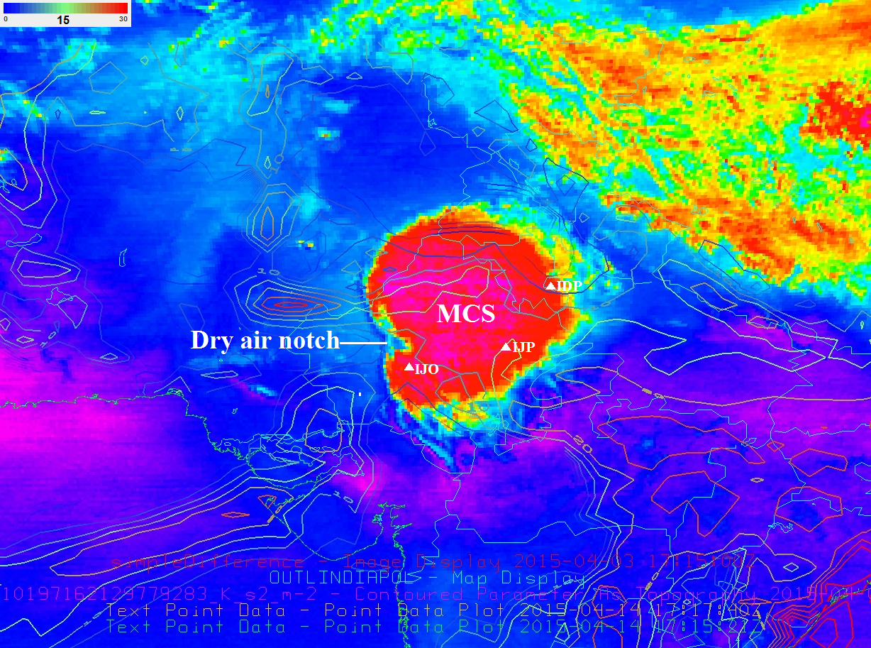
Yesterday’s MCS happened with support of the monsoon trough
A mesoscale convective vortex (MCV) is a low-pressure center within an mesoscale convective system (MCS) that pulls winds into a circling pattern, With a core only 30 to 60 miles (97 km) wide and 1 to 3 miles (4.8 km) deep,
But an MCV can take on a life of its own, persisting for up to several days after its parent MCS has dissipated.The orphaned MCV will sometimes then become the seed of the next thunderstorm outbreak. An MCV that moves into tropical waters,
not 2005 ,its april 3 -4 2015
https://kenpryorblog.wordpress.com/2015/05/11/initial-assessment-of-downburst-potential-products-over-india/
yep…its 2015…
The same is happening all these days whenever Chennai getting squall
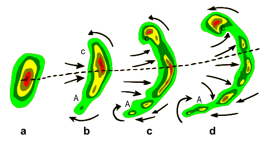
I saw some reports like some tornado like thing in northern suburbs in madras too https://uploads.disquscdn.com/images/b526dd270a312d333b64ebfdf772dc706461722077d36ebe968d7ac44e7351cb.png
Look at that area C is more prone to tornado creation
was reading this yesterday in wikipedia.
me too read this yesterday night
Drizzles continued all the way from Hyderabad, Raichur ,Mahaboobnagar Rangareddy…..
Oijili in Nellore district got 47 mm from yesterday’s thunderstorm
Typhoon Soudelor while making the Landfall. Exclusive video..What a horrible sound & pounding
winds.. A very threatening one..
GFS expecting good rains over east and peninsular INdia during second week.
http://www.monsoondata.org/wx/prec.html
Surface level circulation has developed over NW and adjoining BOB.. It’s associated UAC is embedded in the EW shear zone and present near Coastal AP
yes but IMD wont call it LPA.
Did IMD invent the term east-west shear zone?
Lol I think yes.. They seem to call an east-west trough which is well marked and causes discernible deflections in wind as a trough an EW shear and they tend to have embedded circulations in them like any other trough
Lol, no other weather agency uses this EW shear zone!
Yea, the first time I searched for this term I couldn’t find anything, so I had to observe on my own and ask other bloggers
yes.
Weatherbug, just put your passport pages where it states that u have visited so many countries. I will apologise to u in open blog.
I asked for the car photo. atleast he cud hv posted the 3 stones which saved his life
3 stones? What material
When you get into an accident, let’s see if you get busy trying to save your life, or enjoying the natural beauty around you. Get real.
I do not need your apology, and am not posting sensitive info where everyone can see. Let’s take it offline, at a place of your choice, and a time of my choice.
and Date will be of my choice
Treat?
There are many mesoscale convective systems in India every year especially in the east, over WB and in Bangladesh too. Sadly most of these that occur over east, N and NW India go unnoticed because half of the officials have no idea on what an MCS is and those who do can’t mention it because IMD doesn’t include an MCS in its terminologies..
attacking IMD ?
Full attack
Vs factor?
Aiaiyo
Lol
These are common in SW India also especially during premonsoon.
http://www.researchgate.net/publication/258731175_Evolution_of_Mesoscale_Convective_System_over_the_South_Western_Peninsular_India_Observations_from_Microwave_Radiometer_and_Simulations_using_WRF
Yes.. I’ve noticed a couple in September and October
i dont know the year..but ther was one severe ts in delta district in the month of september..it lasted for whole night and moved very slowly into bay waters..next day NAVY NRL numbered and tracked it as there was vortex embedded in tat cluster .. shld be 2011 or 2012
2012 last week I think. I remember Chennai Sept 10th 2013 rains too, MCS was present with a discernible vortex
oh if v get that exact date,v can hav a look at tat in sat image!!
Should be around Sept 26th-28th, because winds turned easterly from 29th. I remember those drizzles well
Oh yes the massive rains in Pondy on 9th Sep 2013!
2013 : Pondy :: 2011 : Nunga !
Omg…chaos so early in spicy Saturday
Someone is adding fuel to the spice!
2nd Saturday effect
@guest11k:disqus yes the changes r now getting reflected in 7 day anomaly charts .. lets see how tis one behaves in next two days http://www.tropicaltidbits.com/analysis/cdas-sflux_ssta7diff_global_1.png
Omg positive iod forming clearly!
if tis battles the odds for next 7 days, then there may be a signature of positive iod
ECMWF picking up weak LPAs over Arabian sea. These LPAs will further help in positive IOd development.
tat is the strengthening of near equ trough.. sign of MISO getting established
I think upcoming MISO event around 20th August may again cool down IO.
it will start to establish by 15- 16th august and start to impact s.india by 19-20th.. tis year elnino is in mindset to support basin wide warmg rather than typical positive iod..
Yesterday Night TS
Sriharikota – 14 mm
Taramani – 8 mm
Thirukalukundram (near Mahabs) – 8 mm
Marakannam – 8 mm
Kelambakkam – 4 mm
Kunnathur (near Mahabs) – 3 mm
Thaiyur – 3.2mm
MCS developing near WB Orissa North Telangana will be very destructive….
It hailed heavily in chevella near Hyderabad … MCS that formed in the early morning of Feb 2 2013 (very rare with dry notches surrounding the MCS)https://uploads.disquscdn.com/images/695911889a6b9f8aa8bec4d71614536b77aad2c1c662a2d07a9dd27673cd8f56.jpg from a https://uploads.disquscdn.com/images/27053a7a62d5f5357f480b5021a498be4aeb8faff1251e763c9859912ce53f9d.jpg
Oh yes those storms were very very strong.. Even Chennai got rains from that WD front. I remember whole roads in AP being covered in hail, so much it looked like snow !
GFS started to pic heavy rains in peninsular India after 16th
WeatherWhys® – Accuweather
The number of severe thunderstorms in August is typically lower when compared to the spring months. A weaker and farther north jet stream in combination with warmer air aloft limits the potential for widespread, organized severe weather. In the spring, the jet is more powerful and there is cooler air aloft which leads to much greater instability across the United States.
Many parts in AP and eastern Telangana could see showers today
Almost 1/3rd of august is gone….and poor week ahead for Aug team….physiological advantage for sep team
why no rain for couple of day, still 15 august
Slim chance ahead
Meena has won!
Lol.its not meena vs nunga, its about Aug vs sep first
poor week for aug team ahead?? or poor time for sep team guys ahead?
Abstract august will surrender to spectacular September
Correction it’s orthodox August vs abstract September!
Orthodox will be anthrox
Good one
That is psychological, no anatomical discussions here!
Above comment made by me is in other dimensional… You don’t get confused
No monsoon will exist this september
You mean exit?
Sep in elinio is like icing on the cake for s.peninsula
Lol
Rofl
its LANINA tat favour sep with devastating floods!! also make the conditions ripe for late withdrawal of swm
Can lanina in 2016 be very strong
Yes it will
Then I should wait for Happy new year …Hope 2015 goes fast
Yes
but models picking up awesome rains for peninsular India in September.
Link please
CFS consisently picking up a system near Kerala coast around 13th September resulting in good rainfall ofr TN.
http://www.weatheronline.co.uk/cgi-bin/expertcharts?LANG=en&MENU=0000000000&CONT=swas&MODELL=cfs&MODELLTYP=1&BASE=-&VAR=prec&HH=840&ZOOM=0&ARCHIV=0&RES=0&WMO=&PERIOD=
It may not happen
I’m expecting poor rainfall in September
Accounting the miserable sep in previous years sep should do it better
Lol last year it was decent
Not violent… Everyone has forget about the vulnerable sep storms
Keep an eye on the BOB system. The system’s LLCC will continue to intensify and approach AP/Orissa border. But as we all know due to high shear, the bands are tilted SW in SWM systems. As a result, AP and Telangana will face very heavy rains after a couple of days. Eastern Telangana might even wipe out the current deficits. There will be widespread/FWS rains in S AP and Central AP with scattered thunderstorms in eastern AP(Vizag and such) due to the sheared structure of the SWM systems.
As far as Chennai is concerned, N TN will see 1 or 2 days of widespread thunderstorms before the system intensifies and makes landfall. That day of widespread thunderstorms will occur soon, maybe on Sunday/Monday. Expect good rainfall before cloudy skies take over.
Good news
Yonagunijima of Okinawa prefecture with 402mm is the rainfall topper in Japan from Typhoon Soudelor
I have to study and do some school work, I will not blog today unless it rains.
OK then we can see you around 9pm
There’s always a tomorrow to do school work.
My last post before I go to study, there is an MCS currently near Nebraska in USA. Refresh for GIF https://uploads.disquscdn.com/images/df8ca244336ece3a5aa12732bb6f6da5591007477c4de9a60c8d5835a97a1038.gif
what is MCS?
Madras cyclone system
should be above
Mesoscale convective system
ok, thanks
I was kidding…don’t take it serious
Lol
about what ? madras cyclone system?
Yes
Absolutely
oh ok ok , no issues
Dinagar from pondy and kiran from AP never take anything serious…
Myself too…
Looks like there is a low pressure area over there.
But raijin said 402mm is the highest
Weather bug here?
All names are similar
even now the minimum is atrocious 27.4 C. When will our everlasting summer end.
It’s only August sunspot!
but rajesh, we are facing blistering summer from march mid. we need some respite. we need minimum to come to at least 25-26.
Sadly, we have to face this heat till October!
Most of us are convinced somehow with this temps than sultry/humid earlier days
kerala and west coast is going to get superb rains as clouds have started to gather near maldives.
*** Highlights of Aug Team’s Performance in the First Week ***
It was a wonderful performance by the Aug team in the first week of the Kea Blog Hunger Games. Infact, it was a collective display of team effort right from Day 1 of the Games. The highlight of this week was the high voltage batting display by the Aug openers on the night of Aug 4. Will they take this momentum into the coming weeks? All depends on its middle-order batsmen (like Sel, GTS, etc.) who are yet to show their true potential.
Openers did a magnificent job. Middle order is in bad form. Hopefully all rounders and tail lags and adds another 100-150 runs.
oh no..tail shud not lag..it shud wag..otherwise it will be a bad finish for Aug 😀
Some how you sensed the truth
Wizard kid ( harry potter of kea blog -Susa) rain charmer…violent vinod all are in sep team
September team are scared of the reality now. This 50 mm is like gold
we cannot write off september yet. last 15 days of september many times proved dangerous.
22 days of august still remains
Though I am for august, september also has its peculiar characteristics.
Yes..this Game will not have a clear winner until Sep 30
It’s as simple as that. Meena will win Aug. Nunga will win sep.
Dash what r the rules
September can be scared of dryness!
Awesome rains for TN from the system near kerala coast around mid September.
http://www.weatheronline.co.uk/cgi-bin/expertcharts?LANG=en&MENU=0000000000&CONT=swas&MODELL=cfs&MODELLTYP=1&BASE=-&VAR=prec&HH=1128&ZOOM=0&ARCHIV=0&RES=0&WMO=&PERIOD=
Lol
This year september will end with high note..not for TN only ,but for whole india also..
No chance
12.30 visible satellite.
Most of TN looks cloud free!
especially south TN looks worst than rajasthan. Real desert of india should be south TN.
Nem Is there for south tamilnadu
..it can’t be desert
even in NEM, only southern most districts of tirunelveli, tuticorin enjoy the most. virudhunagar, madurai and dindugal miss many NEM.
What will be the impact of elnino on Indian winter….I need 4 to 6 degrees in Hyderabad to enjoy coming winter
U need rains or winter
warm winter.
Just a fun survey (will not be implemented as per rules) 😀
If the organizers allow bloggers to switch teams now, who all will be accepting that offer?
I think Captain Susu Maddy will be first to accept… lol 😀
All pa grp members will be rrady I think.. all we need is one more electric storm today or tomo
Apram andha Ammena easy’ya un sideu thallitu vandhuralam partner 😀
Yes easy to brainwash PA grp members 😀
Except susu* 😦
Yes but we can drag Ameen lol
Susu killadi..
Instead of switching teams..organizers must decide the rules first..simply the competition is going on without any confined rules..
MH 370 back in news…France begins its serach operations
*search
please dont kill already dead snake.
completely mysterious.
What are they going to possibly find?
they found a flight’s wing. but not sure whether that is MH 370 ‘s part. so started searching for more parts
The debris is floating all over the indian ocean!
Yesterday’s minimum temperatures..
Lammasingi – 16.8 degrees
Paderu – 17.6 degrees
Hyd sez – 22.0 degrees
awesome. enjoy
Lol.
Lol…1 day ts rain is enough? Sep will have more like this
This time August will be good but September will be great.
October will be the best aa?
No. From late November till mid December will be the best period for Chennai.
No chance guest11k
^^^ Flash: Jeet’s forecast ^^^
Rofl…Ive seen more
Lololol
Omg..rains for ap…no it should not happen…
enna oru nalla ennam. why poor guys will become rich guys?
Yes poor should be poor,rich should be rich always
edhu konjam sadist mentality madhiri theriyala?
No…kiran should be poor…lol
Typhoon #Soudelor has dropped 1226mm (48.20in) of rain in part of Datong Township in Yilan County, Taiwan: http://ow.ly/QE4wl
They really do not need this kind of rain, but look at what they get. We need, but look at what we get!
Hello
Hello bro’…nalama?
Iruken bro…now Wr r u…means which place
Precise location, Bangalore. Very precise, Apollo pharmacy..getting meds for a sore throat after y’day’s drenching LOL
Ok u r native is bangalore then
Cheee I do not like this place one bit. We bagged a new project and I am forming a team here. Grew up in and around Ranganathan st!
Ok then Wat about abroad
what’s ur gmail?
atchu.zinda@gmail.com
Added..rather, invited
Okk
Shall I del..
no problem, he too deleted
But it will be appear until we will refresh
Yeah
Dude, I thought you are in Chicago!
Why can’t you join in our whatsapp group?
You are welcome
How do I join?
Give your num…I add you
Give & take policy will not work with hm
You’re also welcome
Lol
That is their weather phenomenon..what to do..it lies near to equator..
Lol, they are not near Equator!
they are even above tropic of cancer.
Yes, China is well above Tropic of Cancer! Excellent country, excellent weather!
The sea breeze often behaves like a gravity current, which is a mass of dense air that propagates into the ambient air by virtue of the hydrostatic pressure gradient between them. Thunderstorm cold-air outflows also behave like density currents and the rotortype circulation at their leading edge is due to pressure-density solenoids (see below) between the dense and less dense air.Points of intersection between the sea breeze front and horizontal convective rolls represent regions favorable for the initiation of convection.The general physical mechanisms of the sea breeze have been known for quite some time and can be explained by pressure-density solenoids associated with landwater surface inhomogeneities. Because of the strong heating of the land the mean temperature of the air above the sea is lower than the temperature of the air above the land (see figure below). Thus, if the pressure distribution at the surface is practically uniform, the isobaric surfaces somewhat higher in the atmosphere are inclined in such a way that they are directed downwards towards the sea. However, the surfaces of equal density (called isosteric surfaces), are inclined in the opposite direction, i.e. towards land (because of the higher temperature). This means that the isobaric and isosteric surfaces do not coincide and this results in the generation of circulation or vorticity.
Meena 6mm yesterday Adam too received som rains:) rain streak continies…
Saidapet 1.5 mm
yes here too..light rains occured
http://blog.keaweather.org/index_current.php?id=1831#comment-2180918298
Typhoon souledor .devastated..
Sea waves crushing..souledor
Guess where this picture is taken
Looks like parangi malai :p
correct jon. it is st thomas mount in chennai.
Our area.. see how green it is
Partner it’s foothills of parangi malai 😛
Yes.. dlf can be seen towards the right side :p
Photos taken today as typhoon Soudelor hit the Taiwan coast
Courtesy:
————–
Westernpacificweather
https://fbcdn-sphotos-c-a.akamaihd.net/hphotos-ak-xta1/v/t1.0-9/11800298_1014187581949000_9079727090336947593_n.jpg?oh=dcb5d3e27b64aa4fc0160474b27c3979&oe=565334DB&__gda__=1446969126_88771b148e3332a9bfc58bcd318e1323
https://fbcdn-sphotos-b-a.akamaihd.net/hphotos-ak-xfp1/v/t1.0-9/10982850_1014187678615657_3578389951263703186_n.jpg?oh=ceb6ed47ffb18fb61837323030da9aad&oe=5639B601&__gda__=1446963793_d38d65f2e4fe77e415fc80c6dc969f0c
https://scontent-mxp1-1.xx.fbcdn.net/hphotos-xpf1/v/t1.0-9/11047943_1014187721948986_4742327924458520099_n.jpg?oh=729dcce8685bd59d0c7ed1fe48ffce77&oe=56378947
https://scontent-mxp1-1.xx.fbcdn.net/hphotos-xpa1/v/t1.0-9/11828679_1014187918615633_5679767424100999058_n.jpg?oh=88c79a2d2457673f56873997d2a817f2&oe=5647DC6E
This morning Weatherbug was in Chicago. Now he is in bangalore.
he is confusing manytimes. Who knows he may be alien also.
You have a problem with that?
OMG Ehsan, when did I say that..your sense of humor is bland and tasteless. I said I am in India for now, which is what it is!
Who wants to join in kea whatsapp group? We can take a few more. Interested ppl pls post your # here
8122091311
9884093870
9894534064
9791510142
9731923296
9884041889
y GTS & Sel not in whats app group?
9444922929
9294058482
All the numbers are added
All who have given their Numbers. Enjoy. Charge ur mobile often. The group will be full of spice, masala, heat etc…. U have joined the most active wap in the whole world.
Added your’s also….
OMG.
Add me +971553199704. Sunder
9003481616
Taiwan is a small island country near china earlier called formosa. But this small country is a leader in many technological innovations. Thats why china although taiwan as part of china never used military power to annex taiwan like they used for tibet.
Weatherbug lives in Nandi woods in Begur Road.
No love lost. Anyone can live anywhere at any time. I think you must get your facts right. I may even have 2 wives and 4 kids, but that is entirely my business.
You’d be better off putting all that energy you expend in wasting your time to better use. If I wish, I CAN post my SS card and Illinois drivers’ (obtained like 4 months back) in here, but then that’s something which is entirely private. Learn to live, and let live please.
thanks for the advice. It only took 2 mins to be honest.. I am an expert in finding things. Since it is private i did not put ur photo. I respect that. If u wish and give permission i can put ur photo. Else leave it. I have seen u.
Some times I love this curious nature of human beings. Infact, I am very curious in nature
i think i found Photo of Weatherbug. If he permits i can put his photo. Else i wont. He is white, angry looking and has light french beard.
He is more or less my age. so he cannot have travelled so many places.
Don’t be jealous you haven’t traveled!
Yes. to be honest.
People have seen my pics in here, lots of times!
No one has seen u like ODM ur a mystery.
You are not right on that count. I did post pics of me enjoying last Christmas and people have indeed seen those!
Including the pic where I’m drunk.
if then, can you post your pic here. if you dont mind. bug.
Post yours man, I’ll post mine.
since you said people have already seen your photo, i wanted you to repost the same if you dont mind. It is not a competition going on here. bug.
Ok so you post urs after I post mine. Nothing is a 1-way alley.
Stoned… https://uploads.disquscdn.com/images/f09058d6e32e101e26d5325971f7e7125a0bb7df4132ce3d198e7d0ec2fdfde8.jpg
happy to see you bug. Thanks for accepting our request.
Now let us be happy to see you too
he wont. No one has seen him too.
bug, thank you. I am keeping a low profile in this public forum. will definitely meet you and others in this blog soon.
Loser
i know you will get angry.
Not at all..have had my quota of Remy Martin for the day, thank you.
Happy family.
Please don’t be jealous of that too haha
No i wont. I said i will move on.
Move move..move out and see the world. Now I’m sincerely saying this, see places..you can if you have that extreme “burning desire” to get out of India and see places..someday I pray you’ll go places..
We all deserve clean air and water straight out of the tap. Which is why we need to see…
Ur looking very smart. U would be 33-35. Am i right.
It is because your characteristics are very rare, people are forced to find some things about you. nothing else. dont take it in wrong way.
yes sunspot. no intenion of exposing him. Just glad to see how he looks.
now we will see the diff bwn the photos he added and the one you have
Its the same face. I will share his photo in the group.
angry looking is missing
Join the blog group sir.
I’d say you look angry.
naana, nalla paarunga (i said its missing in the photo you posted, sirichcha mogam)
Why can’t you join
can’t
Why
yet to get android phone
Switch over soon…you can enjoy life…trust me
Keep it private please. No sharing anywhere.
Yes. I wont. Always put photo in which ur single.
Also no pics where I’m smoking haha..not here but at home in Chi, I do and quite a few of my pics show it..
Angry bug?
sat img update https://uploads.disquscdn.com/images/e62458ef484707cb8bfebc76cd5800f706240840c3619d37e9ed25619b4643c9.jpg
sat img update -sw sector https://uploads.disquscdn.com/images/b632ab99b99316546dc119d54a813231a17da233960e8a6175ebb2765d2523a9.jpg
radar-perfectly obeying the forecast till now.https://uploads.disquscdn.com/images/1e85779da67b8911657a62c768ea4933fd716622018b74932bc2dcaaa26a42c6.gif ing
What a day. Without Jeet supplying fuel, it was active. I will move on.
It means I trained/taught you guys well….
what i understand so far is jon, ODM are very good in geography. I will also add weatherbug in this list.
List of unknown persons
Sunspot – ?
ODM – ?
Optimistic Green – ?
Guest11k – ?
Don’t tell me u don’t know optimistic green
Vela has solved odm mystery too
Honestly its not me.
Oh sorry u r green bee
No its not me.
Green bee?
He is lieing. PJ is greenbee
yes
Yes, obviously
Rame 1975?
guest
Means
Guys, I request everybody to make a trip to st. thomas mount aka parangi malai near guindy. It will definitely interest you. Sunset will be fantastic. Oh, that nice breeze and chennai city’s flood lights will take you to some other world. I am adding one more picture of this fantastic tourist and religious spot of chennai. It is really under rated. The approach road could have been better.
its near to my house
This st thomas mount is a good place for organizing kea meet. Infact it would be fantastic spot for that meet during NEM days. I am planning to go there again during NEM days.
In South, there is Pallavaram Forest, Nanmangalam Forest, Nallur forest (near Tambaram),
In North Cholavaram Forest. And Near our Surya’s there are very big forest PeriyaPuliyur forest, Siruvada Forest and Palem Forest.
And also poondi reserve forest
Twin hills forest ..all the way up /////>>>>>>>^^^^^
I know the twin/combo/dual effect and their capabilities
Blog is silent as all r whatsapping
Will ease offtopic comments here too
I have given my number down kea sir to join me in wap group
Vela is in the adding department
Oh thanks
Temp silently touched 37c today..& hot day of this month..
Because no pop up let no chance of rain , no see breeze set still, but heat its perfect condition for strong TS ,but nothings goes right
what do think happened yesterday night.
Updated list of unknown persons
1.optimistic green
2.guest11k
3.rame1975
4.sunspot
5.odm
all are well experts..
Where is Jon in the list?
Aussies are in well defeat..To avoid innings defeat need more 89 runs..with 2 wkts
Aus A trash Ind A by 119 runs in Chennai
eng trash aus in TB
need 88
need 1 wkt..
give me your #. You r needed desperately in WhatsApp group
i will join next year
who knows WhatsApp will be there next year?
Why are you so fatalistic..
Next year school studies getting over?
No he is retiring next year
Lol
this is called vengeance for angry face
Rightly said…he is essential
That was yesterday
yes, trashing is trashing. today, tomorrow or yesterday
Yes and today is their turn
Ben Stokes: 6/35..if he gets the remaining 2wkts , he will equals with broad..
Lava rolling into the sea creating steam that raise so fast, it released multiple vortices!
Michael Clarke announces retirement after final Ashes test
Haha forceful retirement
I wish he retired after 4th test itself. Or don’t play final test because of bad form. That’s what a true Aussie will do
Sangakara do the same in the series against India
37c rh is 39% chance of rain is bleak
37.1 now
England won by an innings and 78 runs..& won the ashes cup
well done to them. Wish they can retain the Ashes in 2 years from now and even win the World cup in 4 years time.
Next ashes 100% Australia will win
And final test too
how? they are very poor. I think the Smith led Australia will take time to recover, but don’t count them out to win their 6th WC in 2019
Their bowling is fine batting will get better their bench strength is good
their fine bowling couldn’t destroy the weak English batting
If you compare bowling is better then batting because of poor form of batsmen and england is always good at their backyard
less than 1 hour to go for the start of the 15/16 EPL season
Any fantasy league contest is there like IPL?
this runs for 9 months. In between there will be NEM, IPL and many other things.
Today moisture at mid lower level and mid level is excellent so we might see some rain as day progress into night
37.1c temp here
Clarke to retire from test
after next test
He should have retired before Ashes:-) lol
today morning i had a thought of you
gun shoots in a male hotel