
It will be overcast day with chance of few drizzles. Maximum will be around 31c. Chance of rain if any will be mostly during late evening/night.

It will be overcast day with chance of few drizzles. Maximum will be around 31c. Chance of rain if any will be mostly during late evening/night.

Light drizzle
Micro drizzles often….
Light drizzle
Good morning, steady drizzles started in the early morning and stopped now. Grey skies… As I am typing, drizzles are picking up. (Periyapalayam)
Still SOI is in increasing mode
http://www.bom.gov.au/climate/enso/soi.txt
Wow…gud
Drizzle plus 18 to 19 degree temperature plus windy in Hyderabad
Flash…be ready for heavy spells from hybrid-VS-TS starting from today (at evenings) over Chennai as LPA moving little north
http://www.weatheronline.co.uk/weather/satellite/Asia/India/Infraredcolor.htm
Pure hybrid or Impure hybrid?
tomorrow onwards better chances as moisture is penetrating strongly from west-coast. today heavy spells will come very close till Mahabalipauram/Pondicherry.
Cola expecting rains to be happening now
One more cloudy day with drizzles
Booring!!! Need som heat back!!! To get rains
wait till july 1st week to get driest spell of the season 🙂
Yes july and aug are looking worst anything significant should happen in June!!!
Monsoon, defying El Nino threat, boosts crops.
http://www.livemint.com/Politics/FBgiUnYOJsGEcmd9wfVVUI/Monsoon-defying-El-Nino-threat-boosts-Indias-crops-economy.html
OMG!! LPA off SW Gujarat coast has intensified and elongated.. Whole of Konkan & Goa and Maharashtra has been pounded with very heavy rains, much more than expectations !!!!
Mumbai would have crossed 200 mm by now.
Rains in mm till 6:30 am unless specified
———————–
Mumbai Santa Cruz – 191 (2:30 am)
Mumbai Colaba AWS – 178
Murud – 134
Dapoli – 132
Marmagao – 127
Thane – 119
Ratnagiri – 98 (5:30)
Ela – 97
Canacona – 72
Pernem – 69
Aurangabad – 59
Mulde – 49
Devgad – 45
Palghar – 36
It seems North east areas of the City has received lesser amounts compared to North West areas..Areas like Thane, Murud, Dapoli are more towards the eastern side of the region..The reason could be the position of the LPA off SW Gujarat coast..
They have heavily quarried and leveled the mountains in Navi Mumbai. My earlier office had several rain gauges and they confirmed that rains have decreased over a 3 year period.
Ohh..Navi Mumbai has grown like anything in the last 10 years. Areas like Ghansoli, Kopar Khairane. Nerul, Sanpada etc…Even Airoli and places like Rabale…The demand n need for water (Industrial n Hone) is ever increasing there.
First above 150 mm in AP in godavari district
Which town/ village?
Chintur near jaggayyapeta east godavari records 160 mm
Steady drizzles for 5min
Drizzles continuing…
Cool climate in chennai
Radar update (Machlipattinam)
Flash…. .. .
Ew shear zone @500hpa likely to form near sap coast by after noon and wind confluence likely to happen south of shear zone near SHAR. This could create intense TS.
So the mega metropolis (Bombay) has begun its monsoon journey in the right earnest after a delayed start to it by 6 to seven days..
Pelting in Mumbai (Mulund)..my cousin called and said Rain and Train (she goes to work by local train) are a terrible combination 🙂
Flash…it looks system is gaining in latitude, so NAP and S-Orissa will be pounded with heavy rains so soon.
And the best part is, there’s no need to analyze complex models, wind shear patterns etc when predicting rains for a city like Mumbai. It just Rains. Period.
Manaus, Brazil is the only other big Metropolis where it rains so much. But even there not as much as Mumbai. Mumbai is an as yet unexplained phenomenon.
Mumbai under the double lpa effect!
Mumbai rains are not that much complex to predict. Very easy to predict. Only infrastructure need to be developed to face the grim situation rising from heavy rains.
I mean why it should rain so much given the complete lack of greenery and heavily polluting industries, no one has explained yet.
Manaus is in the middle of the Amazonas..that explains it.
Expecting disruption of train services there. Particularly Western n Central Railway. Normally the first downpour causes heavy flooding if the quantum of rains is with good intensity and in a short time..Though BMC takes adequate measures to clean up the entire drainage system, the first heavy downpour always results in chaotic conditions. By July the city settles to the monsoon music and the show goes on uninterrupted..
Spot on ..Have said this few times here since I started blogging.. Irrespective of the conditions, (of course it needs conditions for rains) elsewhere, this city is well and truly blessed The city needs the downpour for it to mange year round water needs to homes and industrial use. The ever growing metropolis will somehow find a way to get its annual quota of rains. The monsoon magic is always special there..
The only analysis needed is when to take out the umbrella and raincoat!
It’s always better to carry right through the monsoon period..
Special..depends on how one looks at it. For a first timer, truly special. But then Mumbai has a special curse called Malaria (endemic zone, though not as bad as Chattisgarh)! And Gastroenteritis and everything else.
Excessive heat wave cools tea consumption in western India
http://m.economictimes.com/news/economy/agriculture/excessive-heat-wave-cools-tea-consumption-in-western-india/articleshow/47728648.cms
Continuous Heavy rain in Mumbai
Mumbai santa cruz 254 mm till 5 :30 am
expecting 300 mm by 8 30 am
Wow……………
Fantastic rains there. Its news when it doesn’t rain there..
Yes…our business capital rocking…..
First mudslide has already been reported near Vikhroli!
Mithi river will overflow and create issues for shanties in and around Kalina/ Airport!!
You can be rest assured of Flooding in Milan Subway, SantaCruz.
“June rains have been good and we expect the same for the next 10-12 days. Despite that, July rains remain a concern. July and August are the critical months,” LS Rathore, director-general of the India Meteorological Department (IMD), told Business Standard. The distribution of rainfall would be crucial, he added.
The IMD in its updated forecast earlier this month said rainfall in July would be 92 per cent of the long period average. The forecast has a model error of plus and minus 9 per cent.
http://www.business-standard.com/article/current-affairs/imd-worried-over-july-rainfall-115061900059_1.html
With IMD expecting 92 percent rainfall for July, i think July month which is most critical for our agri productions, i hope we may tide over the expected crisis to some extent,
Satellite Image
FLASH MASSIVE CONVECTION DEVELOPING NOW AND MOVED LITTLE NORTH AND STRENTHENING SO TDY INTENSE RAINS POSSIBLE NELLOR AND CHN TO KARAIKAL STRECH!!
96B INVEST As of 18:00 UTC Jun 18, 2015: Location: 16.7°N 85.8°E Maximum Winds: 20 kt Minimum Central Pressure: 1007 mb
MACHILLI RADAR UPDATE ONLY DRIZZLES BAND:-)
Mumbai water logged due heavy rains since last night
Courtesy : SreeKris (The Hindu)
MUMBAI RADAR UPDATE
while Mumbai getting heavy rains, our neighbor Kerala having a poor monsoon so far.
Two weeks after its arrival, the southwest monsoon recorded a deficit of 48 per cent in the state. Rainfall was ‘scanty’ in Idukki, Kozhikode and Palakkad, with a deficit of over 60 per cent.
Compared to the normal rainfall of 34 cm, the state received only 17.7 cm of rain from June 1 to 17, according to the data from the Met Department.
The rainfall in all districts, except Idukki and Kozhikode, fell in the ‘deficient’ category (deficit of 20 per cent to 59 per cent). While the rainfall in Idukki and Kozhikode recorded a deficit of 62 per cent, a deficit of 60 per cent was registered in Palakkad district.
http://www.newindianexpress.com/states/kerala/Kerela-Monsoon-Records-Deficit-of-48-per-cent/2015/06/19/article2874075.ece
Cloudy and Cool day continues in Karaikal. Expecting some TS to happen in Evening and Chennai is expected to have light to moderate rains in night.
Most of the Tamilnadu will record less than 35’C today as well.
Moon engulfed in permanent, lopsided dust cloud http://thne.ws/1IQpkOI
Kea, Asad, Ameen and others who observe, wish you all Ramalan Mubarak,
Pray for us also
Asradh and atchu:-)
thanks
Any chances of intense ts after2.00pm?
If you observe the radar image of Bombay closely, the entire south, south west, North, NW areas are getting pounded right now. The core city areas like Colaba, Dadar, Wadala. Matunga, Sion, Andheri and Santa Cruz, Navi Mumbai under intense rain spell. Thane too.
Especially for you KEA, Ramadan Kareem..
thank you
Good Morning All,
We all come to blog when it rains in Chennai.
But Shiva comes to blog either it rains in Chennai or in Mumbai.
At times when blog is at silent mode
Chennai is silent. Blog is silent.
It won’t erupt until Oct 3rd week in chn
Keep your fingers tightly crossed!
Gud mrng sir ur profile is suberb and any chances of intense ts after2.00pm?
Yeah Paartha, I just cannot hide my excitement when it rains in that great city. The city deserves every mm of rains for all the noble souls of the metropolis. Same feelings I share when it rains here in Madras. Its not easy to forget all those years of my Bombay life and monsoon. Every monsoon, I dearly miss them.. Hopefully nature is kind enough for our city this NEM.
AsI told Jeetender, keep your fingers tightly crossed..let all shear patterns and models be demolished and let it simply Rain hard!!!
u seem to be so happily excited when it rains in Mumbai i observed the same as partha observed.
u can share in the kea bloggers story too.
we are eagerly waiting for evergreen real stories of Novakji.
Thanks a lot Grully. I’ve shared it few times here.I can share it again. But my only worry is, will bloggers get bored or it may sound repetitive..
rain stories will never bore,
All bloggers like you Novakji
No one can stop SWM progress from now on, see the WV insat image, the WV has progressed up to Jaipur, Jodhpur and New Delhi latitude.
The moisture is increase up to that latitude, hence SWM will progress and set in normal dates over those places.
Rainfall till 8 30 am
Mumbai santa cruz 284 mm
Mumbai colaba 209 mm
Heavy Rain Paralyses Mumbai; Trains Hit, Schools Closed
http://www.ndtv.com/mumbai-news/heavy-rain-in-mumbai-hits-train-services-civic-body-issues-alert-773151
Has anyone drawn SWM-line between north India and south india?http://www.weatheronline.co.uk/weather/satellite/Asia/India/Infraredcolor.htm
Fantabulous SWM morning here in Bangalore! Drizzles every now and then. Wonder, how these monsoon clouds still have something in them after crossing Western Ghats!
Here also kalai na three cosecutive drizzles morning maximum is 27.8as of now
Yesterday Yercard received two hour of rain… Pic : Yercard Lake
Nice and Good Picture
Contest 7 is open.
It will close in 1 hour. Pls send entries immediately.
Deadline 11 am
http://www.kea.metsite.com/contest.php
Mumbai – Mahim station as train services are suspended (from web)
IMD: Monsoon to be good through June
http://timesofindia.indiatimes.com/india/IMD-Monsoon-to-be-good-through-June/articleshow/47727309.cms
even for July they expect 92% with +/- 9 %
just read the comments. All mocking IMD
My God..people have a big fight with wife/ husband at home and pour all their frustrations on poor IMD!! Unfair
mum rains snaps frm media
chennai 1.2 mm cherra 0.4 mm 😛
0.0mm in Thaiyur (Kelambakkam)… Atacama in Making 😦
Face Palm arrived
yesterday big fp to indian cricket team 😛
they deserve it,
ya thy need to loose series now to become laughing stock for all
effect of IPL tiredness, wrong time to conduct a series
wish remaining matches are rained off
yes, to save us from humiliation
who is in the photo
romba mukkiyam 😛
then only i can find diff bwn 1.2 n 0.4
George bush fp at obama
big win for us
Dinagar will be extremely happy 😀
Thumping victory!! This has compensated for yesterday’s loss to bangladesh
Jon,
We have to celebrate this victory, Nunga has beaten Cherrapunji in yesterdays rainfall, Kea arrange for treat.
Agreed. rare occurrence during SWM
The King enjoying Monsoon in Bannerghatta Park..sent by a colleague
Always felt a city like Bombay works on only one Weather model. That is EMNBM..(Exclusive Mother Nature’s Blessings Model)
It may not rain some 35 or 40 kms from the core city areas. But the city is never deprived of its share whatever be the conditions ..
ahaan…
Karaikal AWS only – 5mm But North and West of Karaikal would have got nearly 30 – 40mm.
Places like Tranquebar, Sirkazhi, Kollidam, Mayiladuthurai, Peralam & Tirunallar got Good Rains.
Stroms just Skipped part of Karaikal with Light Rains.
Only blue bands when we see the red bands in radar:-(
in coming days
Idha tha june 1st la irundhu solringa I think tdy also light to mod rains:-(
Macili
Steve today forecast for chennai
chances of some heavy shower in evening and latenight and but I think it only mod to light rains once the system move inland r weakened then our pure vs monstor will form nw of chennai or east of chennai:-)
Image loop
East coast’s first low pressure too weak to bring much rain
The first low in the Bay of Bengal (BoB), which formed on Wednesday (June 17) over the west-central Bay off south Odisha and north coastal Andhra Pradesh, may not intensify into even a ‘depression’, the next stage of a low pressure, predict met experts.
Weathermen from the India Meteorological Department (IMD) attribute the inactiveness of BoB’s low pressure to various reasons, particularly the spot of origin of the system.
N Narasimha Rao, senior meteorologist, IMD Hyderabad Centre, said BoB’s maiden low pressure this monsoon originated too close to the coast between south Odisha and north coastal Andhra Pradesh where as the first low in the Arabian Sea originated far from the coast.
“The survival rate of low pressures born very close to the coast is very less. The same principle will apply to the BoB low pressure. The chances of lows born very far from the coast transforming into cyclones is much higher as happened in the case of Ashobha.
http://timesofindia.indiatimes.com/city/visakhapatnam/East-coasts-first-low-pressure-too-weak-to-bring-much-rain/articleshow/47728844.cms
Would be interesting to our bloggers reaction when we (Madras city)get similar rains of 300 mm in about 8 hours or something like it as to what Bombay is getting right now..Wish and pray for such a scenario soon here.
Wait for NEM 2015 🙂
Remember TBM getting 310 mm in 9 hours from Cyclone Baaz back in 2005 ,,,Something like that again would be extremely delightful , along with power packed winds …OMG !!! waiting for such a day ……
I’m waiting…….
310 in 9 hours? R u serious
Yes ,we did get that back in 2005…remember Nunga some 240 mm in 24 hrs …
Nunga got 250 mm totally from Baaz
Oh okay ….
but next one few days later, Fanoos failed big time for us
Yes , that was hyped much more..landed as a depression near Pondy without any hint here …
Sorry somewhere between Pondy and Nagapattinam i guess
Vedaranyam
Oh…yes , guess it went down south with weakening , LF was expected somewere up the coast
it doesn’t matter, by then nunga had received 1943 mm in NEM
water levels in Adyar river was touching the TBM – Beach railway line bridge …I just went in train from TBM to Beach to see that
yes kea…what doubt at that entire tambaram-pallavaram flodded …i think so its december 6 2005
Baaz made landfall on 2nd
but my wish is if that much rains possible, let it be in the phase of 2 to 3 days, it will recharge the groundwater table, if it pours in some hours, most of it will go to drains
Yes , that would be very useful without much run off…
yes, i have seen many a time, when the lakes are nearing full, water has been wasted through canals, in around tbm,
Yes, that is the secret behind good ground water levels being at reach
absolutely super day it was GTS.I remember the rainfall figures
Tambaram-31cm; Meena-28cm; Nunga-24cm
as last year chennai got 150 mm in 4 hours on oct 18 2014
If Chennai gets such rainfall, none of us would be able to access blog. No current, no mobile signal, no internet
Just had a talk with sister in law now.. who is in Mumbai…. Its pounding there.. Local Train Services cancelled at many places..
schools closed
That I didnt ask….
its in the news
ohhh. ok
10 min to go. Hurry and take part in the contest
Will need to Include Hill Stations too in Contest?
u suggest me tomorrows contest
Ok will send later
Will Konkan Railway services (esp. Delhi Trivandrum Rajdhani) be disrupted in the next 3 days due to rain/ mudslides?
:O Contest was created and closed while i was on commute 😀 anyhow my entries are: 34C+ stations:4 Hydrebad-47mm
N.AP & S.Odisha and Coastal Maharashtra in for Deluge
How about Chennai.. can we expect some rains today????
Light to Moderate Rains possible around Night in Chennai
Today very less rain for Nellore Chittor chennai…
A mild drizzle cannot ruled out by the bands.
overall no chance for rain
asusual……..
Hulikal doing real bad gets a zero again 😦
warning issued to Mumbai. biggest wave at 1.58 pm to attack
sir no tsunami for 350 years nu sonnangalae
high tides are common in Mumbai during monsoon periods, even 2 days back it came
ohh…ok
not tsunami its high tides season in Mumbai
OMG,
NEM mood has started now itself???
Those days people would waiting SWM season to end to expect NEM rainfall, till that time there wont be joy. but now as soon as SWM sets in, peoples mood has started to talk about NEM right away, they don’t even wait for SWM progress itself.
That is the voice of deprived people of TN, in terms of Rainfall.
Vijayawada & Pune getting pounded
Once again from IMD, PAC underreporting???
Low over North East Arabian Sea, feeding Mumbai with pouding rain.
http://earth.nullschool.net/#current/wind/isobaric/700hPa/overlay=total_cloud_water/orthographic=-278.51,14.08,1569
Rame story has been added. Read his and other 54 stories of Kea bloggers.
http://www.kea.metsite.com/bloggers.php
Wow featured comment for rame!!!
hope its bcos, he appreciated odm, captains favorite – joke pa
Oh must be true
Mumbai officer on duty!
As i was saying, MJO has weakened further in Phase 4 and entering into Phase 5 as weakest one, since the impact could not be created in Phase 5 due to strong HPA’s presence and SST decrease.
Also the blue line depicts the Negative OLR enhanced over India and especially over North Bay of Bengal. Another convection coming in from West Arabian Sea towards India, this blue line too depicts strong convection, hence the SWM progress will be faster from now on and more rain expected over West Coast and Central East Coast regions.
Pouring drizzles
then my title is spot on
Heavy drizzling here……….:-)
No school?
Heavy fever:'(
Neenga Ameen part 2?
Yes, I think school going guys got addicted towards the blog
Probably
???
part3, part 2 is vijay fan
Super
Appa neenka computer pakka kudathu. Take rest
I’m blogging from mobile pc pakkam poga kudhunu tha mobila blog pannra 😛
are u there in fb?? @steve
Yes
fever aa unaku??
Yes da
Sry anna:-P
hmm…take care…
Thangu……..
unaku facebook la account eruka steve??
Hmm iruku
I think chennai as to face the summer phase 2 from tmrw
hoping so…..only evening ts can save us……
For how many days
Maybe until July
till july our temp ll be 36-37……from august 34-35………from sep 33-34
As I always maintain, Chennai-ites are on the whole healthier than ppl in other cities..sweat flushes away toxins. Of course, mosquitoes are something the gov’t should actively control.
Rain statistics in july and aug in chennai
july-110mm august- 130mm
No no july177mm
August288mm:-P
he asked average rainfall
ohoo……
Yes possibly from sunday
Hmm and then it may continue till July I think
But, ts will be seen, hardest part of June is over but Evey thing is pushing late this year for chn, summer/swm onset so we might see furious face of June in the later part too
Chennai
Nungambakkam
Min Temp – 26.6
Rain – 1.2mm
Meenambakkam
Min Temp – 24.8
Rain – 1.0mm
Heavy rains hit train services in Mumbai
“Services are suspended between CST-Kurla on main as well as harbour line. Thane-Karjat/Kasara, Vashi-Panvel and Transharbour services are running.”
On CR, tracks are submerged at Kurla, Vikhroli, Sion and Parel. On harbour line, water level had reached the height of platform at Chunabhatti station.
On WR, slow corridor services have been suspended due to heavy water logging at Matunga. WR officials said, “Fast line corridor were not suspended but trains were running at “snail’s place”.
http://timesofindia.indiatimes.com/city/mumbai/Heavy-rains-hit-train-services-in-Mumbai/articleshow/47730720.cms
Why there is no karaikal in this list because they told that there was 45 mins of heavy rain
Give the courtesy to Mouli!
He has uploaded many photos but nothing goes into the records
West and North of Karaikal got Good Rains.
Places like Kottucheri in North and Tirunallar in West could have got 20 – 30mm
Mouli said its rained…but imd aws got some less rainfall…but he seen some heavy rains and send snaps too
Mouli sir send the snaps to IMD
Lol
Yes atchu it Poured North and West of KKL and core areas of Karaikal has left out with Light Rains.
It might have rained for a while with strong winds and lightning. That’s all.
No kalai it rained moderate to heavily for 40mins and 2 hrs of Light Drizzle
What’s the rainfall amount you expected after that rain?
Surely Tirunallar and Kottucheri would have got 20 – 25mm i was travelling at that time.
As per IMD only 5.2mm of rain
Thats the amount recorded in Core areas of Karaikal near AWS
Rainfall must be widespread
No widespread Rains in Karaikal. Widespread Rains where from Chidambaram to Kollidam
Is this 5.2mm? Taken North of Karaikal around 3 – 4km
Mouli, don’t guess the rainfall amount purely on the basis of stagnated water or look of clouds. Its the accumulated amount that matters!
Iam not calculating like that way It rained heavily for 30 mins at these areas it could have been surely 15 – 20mm. When i Enter core areas its just wet Roads no water loggings just light rains and Drizzles near Karaikal.
send this snap to IMD
Lol, What does IMD say?
Aws may not be working or maintained properly
Dinagar leave this it was correct figures only from IMD it doesn’t rained heavily in core parts
Ok let us move to new topic
Even u see such difference between Pondy and Pondy AP
But not even 1cm of rain
bro rainfall varies from place to place…..you see in april meenambakkam got 103mm where as nunga has left dry with 6 mm….same case here also
Karaikal to Kottucheri 4km and Karaikal to Tirunallar 5km it surely varies with Rainfall. TS came from west
Chidambaram aws is also not updating. Think some issues
Heavy rains paralyse Mumbai; train services affected, schools closed
Expect the summer to return this weekend for Chennai
It will be sultry this Sunday due to LPA moisture with highs of 38C.
Watchout for ts too
Less chances for that too.
very bright chances ahead
Maybe until June only we have chance and that too can be expected only at the last week so until then let us enjoy the sultryness
r u comparing with pos iod
Yes and also keeping mind on models
Vignesh…….even postive iod comes…our regular ts wont disapper…it ll show its power always….i hope this positive iod ll not decrease our rainfall
If you are saying positive iod does not impact our swm means then why in 1997 year we got less rain in swm
see even neutral iod, negative iod years we got deficient in swm examples- 2003,2005,2009…..all doesnt matter…lets see….i hope it ll not affect much
July is better than june, Aug will be better than july etc etc, check chennai records for further info
I told for next week. Not for the entire season. The LPA in NW BoB will show its power! Wait n watch.
Its not a powerful system to suck entire moisture, moreover its not may month summer system, hardest part for chennai is over is what I mean
u r in bangalore…saying this very happy????
I am saying the reality!
Where in B’lore do you stay bro’? I am temporarily in B’lore as a replacement for a colleague
Madiwala and Electronic City
Maruthi Nagar? I saw them laying roads and cleaning drains there recently
Ya, Underground drainage system was overhauled. I am nearby Maruthi Nagar, not exact
I know that area because sometimes cab uses it as shortcut to reach Bannerghatta road from Whitefield, but roads are v narrow and cab has to squeeze thru, literally
Bangalore climate-a enna sollalam? Good- because it’s optimal/ not so good because many ppl have pollen/ wheezing issues?
Pros and cons will always be there. Life should move on.
Chennai Corporation looks to wrap up first phase of cold milling of roads
Under the first phase of cold milling, where the top layer is scrapped
off, and proper slope created to drain rainwater, the Chennai
Corporation has completed work on 36 km of 44 km of roads.
Sources in the civic body explained that bituminous macadam has been
laid on 36 km of roads and by the month-end, the fine layer of
bituminous concrete will be laid.
“None of these roads have proper slope so we are correcting the profile
of these roads and newly forming camber or slope. Since we get police
permission to undertake work only between 11 p.m. and 4 a.m., it is
taking time. Also in one day only 1,500 sq. m. to 1,800 sq. m. of road
surface can be milled.
After that the blue metal is scrubbed and removed and then camber correction done,” the official explained.
Which parts of Chennai
they have scrapped the old road outside my home and office 3-4 weeks ago. When will they put new road?
This is causing so much nuisance to all.
Mail sent for Tomorrow Contest
thanks
I suspect Senthil did what he said in wap 😛
wow!!!!!! sun coming out of clouds in tirupati after 2 days rest
we didnt see sun for past 3 days
haha….will come soon frnd
1997 & 2015 june mid week sst anomalies
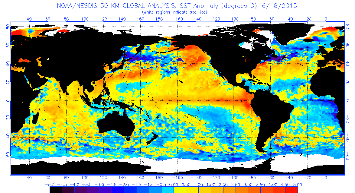
almost similar dude!!!!
Yep but 1997 sst anomaly in arabian sea is better compare to 2015
but indian ocean below equator is cool in 1997 than 2015
Pacific looks similar but whereas IO looks little different.
SST over West Indian Ocean has started heating up early in 2015 when comparing to 1997.
Also North Bay is hotter now than 1997
pls post 2009 anomalies also selvan…
Sel, is the base climatological period differing much for both these charts respectively?
@ kalai
Worse days of the year is over for chennai, hereafter rainy days will increase month by month and so frequency of ts
but Jupi expects a horrible July, August and September for us
In terms of rain?
Yes
IMD also expecting the Same
what does Vela expect?
Bad July, Aug and Sept….
That means no rain?
ECMWF expects that… Not me
The above words are applicable only for normal swm but this is elnino with positive iod
Don’t expect a 40C. But a 37 – 38C day with horrendous humidity on the cards
Yes absolutely right
Who can expect a 40c in late june
Kalai Menna has seen 40 C+ and Nunga too sometimes in mid July ..2005 is one such time. Usually it happens when westerlies /SWlies turns out gusty at surface levels ..with no cloud covers
Ya, I expect normal Chennai weather to return back next week. This pleasant weather for the past three days is just an aberration
Blessing in disguise
That’s a known fact but horrible days is over
exactly …Kalai…
Yes it is possible in Jul-Aug i.e. during “Adi” month . There is a saying “Pon uruga kayum” and MaNN uruga peiyum” – meaning even gold will melt during this period and and sand will erode due to heavy rain
Yes Sir exactly , Aadi month is what I had in my mind ..aadi kaathu…
Aana aipassyil mazhai adika matenghudhe
Have heard the same saying said by a granny once for September month also …
It is for “puratasi” month which is mid sep – oct, they say it.
Any plans of moving to Chennai from B’lore?
No comments!!
Till 10 more days in June and anything can happen
No chance for 39+
38+ itself doubfull
38 is alert zone
38-39 possible from Monday onwards
Ya, this is what I was saying! 38C is sure shot.
Its very own chennai climate, but the worst part of the year is gone
Chennai min will be greater than max of other places for a few days after SWM sets in. An interesting statistic Chennai only can boast of!
But it will be good yo track ts but elnino holds the key
Ya, when monsoon pick up in Central India, normalcy will return back! As u said, worst is over but worse is not.
Btw chennaties are adapt to it
Btw chennaties are adapt to it
exactly, expecting 38/39 for at least 3/4 days before the month end. Finishing touch to our summer 🙂
July highs previous years
2014 – 39.2
2013 – 38.3
2012 – 38.8
2011 – 38.0
40 might be over hopefully, but hot weather will stay with us till NEM
Guaranteed
at least uncomfortable nights won’t be there anymore
Occasional ts will cool down
I am trying to pinch myself to find out whether I am living in the real world. Unbelievable post from you, but makes cheerful
I’m saying the reality
Today evening TS to come to pondy
91W INVEST As of 00:00 UTC Jun 19, 2015: Location: 13.8°N 113.3°E Maximum Winds: 15 kt Minimum Central Pressure: 1004 mb
Chennai is also having the same pressure ie 1004 Mb
92W INVEST As of 00:00 UTC Jun 19, 2015: Location: 9.7°N 130.9°E Maximum Winds: 15 kt Minimum Central Pressure: 1006 mb
96B INVEST As of 00:00 UTC Jun 19, 2015: Location: 16.9°N 85.8°E Maximum Winds: 20 kt Minimum Central Pressure: 996 mb
Show it on the map the 3 lowpressures
Tropical storm risk potential increased since yesterday over bay of bengal.
Lots of pop pup in mw of chn any chances this pop pups intensify in to strong one?
No pop ups where is it
We have to pay principal + interest in the coming days for what we enjoyed for the last few days
Simple interest or compound interest?
its kandhu vatti
Deep Depression likely as per ECMWF and GFS in next 24 hours, also the LOW has already intensified into a Depression, but IMD now in MID Day will say as WML.
I just found a interesting observation .
Mumbai flood occured on july 26
Tsunami on Dec 26
Gujarat Earthquake on Jan 26
Chennai rainfall flood on oct 26
There is some significance with natural disaster and the date 26 .
My Grandmother passed away on April 26th 2007.
Have always thought of the mystery behind 26th like u ..
January 26th, 1531, Earthquake in Lisbon, Portugal. 30K died.
January 26th, 1700, Earthquake at Pacific Sea. Popular with Mega Earthquake. Impact North and South America.
July 26th, 1805, Earthquake in Naples, Calabria, Italy. 26 K died.
August 26th, 1883, Mt Krakatau, South Sumatra, Indonesia erupted. 36K death toll.
December 26th, 2004, Tsunami in Aceh, Northern Sumatra, Indonesia. 230K people died.
May 26th, 2006, earthquake in Jogyakarta, Central Java, Indonesia. Hundred thousands people death.
December 26th, 2004 Earthquake in Tasikmalaya, West Java, Indonesia.
November 26th, 2010 Mt Merapi erupted, Central Java, Indonesia.
Jan 26th Republic day!
National disaster day!
A catastrophic personal event in my life occurred on 26th, I’m yet to heal from it..also a decent event occurred on 26th..and also many birthdays in my family on 26th..that date..ennamo
Dinagar & Kalai this is the Storm Movement in Karaikal Yesterday 🙂
Circled places have received 15 – 20mm
Pleasant showers continue to drench Blore!
Oru sottu malai illa in Whitefield..where’s ur office
Electronic City
Oh..romba kitta Whitefield-ku..just 40 kms
rained heavily for 10 mins in hebbal..hebbal yuktix aws has recorded 7.1 mm 🙂
And Some more 26
January 26th, 1531, Earthquake in Lisbon, Portugal. 30K died.
January 26th, 1700, Earthquake at Pacific Sea. Popular with Mega Earthquake. Impact North and South America.
July 26th, 1805, Earthquake in Naples, Calabria, Italy. 26 K died.
August 26th, 1883, Mt Krakatau, South Sumatra, Indonesia erupted. 36K death toll.
December 26th, 2004, Tsunami in Aceh, Northern Sumatra, Indonesia. 230K people died.
May 26th, 2006, earthquake in Jogyakarta, Central Java, Indonesia. Hundred thousands people death.
December 26th, 2004 Earthquake in Tasikmalaya, West Java, Indonesia.
November 26th, 2010 Mt Merapi erupted, Central Java, Indonesia.
Don’t forget Nepal quake.it was on april 26th,2015.
And this post was already posted a month back.
Nepal quake was on 25th….please check wikipedia….
Just a random coincidence of 26’s?
6 plus 2 isequal to 8…. 8 unlucky number ah ena?
its removed from RTO
Suspicious then… Anyone knows the reason behind it?
Illa..if you get a vehicle whose numbers add up to 8 and wish to get it changed, they charge a fee
Bug I think numbers luke 0008 or 8888 is removed.
True but not #s which add up to 8
Strongest ELNINO for sure, latest forecast suggest that all time heating of Easter Equatorial Pacific. Expecting the SST to touch 2.5C above normal by August.
NINO 3.4 SST likely remain at 1 to 1.5C above normal which cannot be considered as strongest ELNINO.
NINO 4 region SST will come down drastically and will become normal by August, which is a good and favourable sign for SWM success.
♦ The low pressure area over westcentral Bay of Bengal off south Odishanorth
Andhra Pradesh
coast, now lies over westcentral & adjoining northwest Bay of Bengal off north Andhra Pradeshsouth
Odisha coast as well marked low pressure area. Associated upper air cyclonic circulation extends upto
7.6 km above mean sea level tilting southwestwards with height. The system may concentrate into a
Depression during next 24 hours
today’s temp didn’t even cross 28 so far with no rains around..this is just amazing. could someone tell me, how many days approx. chennai had temp below 30 mark during SWM period ( Jun -sep) in the past. I think it will be 1-2 days. Also those 2 days will be wettest ( light rains all day)..
From sept till jan its below 30 mostly.
Chennai has seen 40’c days in August, the only thing constant about weather is it’s not constant.
No expected rain is constant though.
Enaku ippo than ellam puridhu my gf’s birthdate is 26th.. Enna adi..
Haha ha:-)
Millions of red tuna crabs invade California beaches
It’s a red tide along the Southern California coast as millions of red tuna crabs can be seen coming ashore. Scientists say it’s an unusual sight that could be a sign of big changes to come in the weather.
The last time tuna crabs appeared like this was 1997 … right before a massive El Niño, a warming of pacific waters that causes changes in the atmosphere.
http://www.13wmaz.com/story/news/2015/06/18/millions-of-red-tuna-crabs-invade-california-beaches/28950255/
Friday Mumbai will get heavy downpours , and may relent, ease out at night. But day time showers will aggrevate the flooding scene, as will measure around 75-90 mms by 8.30 pm. Night will see lesser rains.
Saturday will see intermittent showers, but may measure less at around 45-50 mms in the day till 8.30 pm.
Sunday, will also be similar to Saturday, but rainfall increasing on Sunday night.
Saturday and Sunday (night included) may see around 200 mms accumulated till Monday morning.
Report courtesy-Rajesh Sir, Vagaries..FB page.
Mumbai records highest 24-hour rainfall in June in a decade
http://www.hindustantimes.com/mumbai/mumbai-rain-city-records-highest-24-hour-rainfall-in-june-in-a-decade/article1-1360499.aspx
what about July 26th 950MM rainfall in 24 hours?
In June it seems Partha
Only for June it seems
That was only in Santa Cruz. Colaba recorded only about 140 mm for the same day. It was a massive cloudburst confined to a few km radius inside the city.
It received around 500+mm in 24 hours sometime in June1983(or) June 1984. one fourth of the yearly rainfall in flat 24 hours.