Early forecasts call for the follow up system to cyclone Ashoba to affect TN coast. This is around 12 days away and forecasts can change. We need to watch botht he systems closely. Ashoba too could spring a surprise with a twist or two.
Every week we will do a Kea Quiz in Converse forum. 1st quiz is up and running now. Pls send the entries by email only. Entries cannot be posted in forum. Every Friday we will declare the winner.
If the system approaches ap coast..the cloud movement will be ne …then we can expect some rains…. At present pondy region is getting benefit continuosly…
Since it (LPA) has moved more northwest above the position of madi…..the landfall place after recurving would be further north,i.e,Chennai….no need to worry about rains…it will come soon………..
Today they may come out with their report saying lpa has formed in south central bay
If it forms in SC bay, chances are minimal for it to hit TN. I am afraid, this system is all set to create a wet November for Andhra like the one they had last year in October because of WML. If that’s the case, it will affect our so called 2nd week spell.
Expecting a big change in today gfs run.. all of a sudden they r bringing a ridge at mid level around east central India in last run this may restrict the system twrds north..
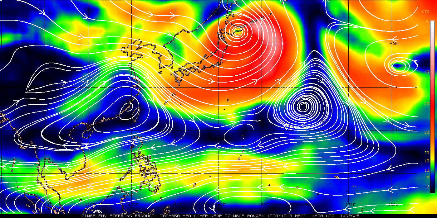
@Selva– Good Ridge and Sat images.I guess that the ridge is being influenced by Nuri as it tracks N/NE.We have only 2 hopes.
1.Nuri suddenly collapses in mid sea
2.Nuri miraculously starts tracking NW/SW
Both are impossible.
I am not sure whether there are other factors which will help the ridge to establish itself as west as possible.
Iam in learning stage of what is ridge and how it steer the cyclone.. With my understanding i maked ridges in below image. Kindly explain me how it is steered and ridges(because my understanding might be completely wrong).
Ridges r the extension of the hpa. They tends to rotate in clockwise direction. When system falls under the influence of ridge ,system moves along the rotating directional flow of the ridge
So we have 2 HPA.. One in west and other in east near burma.. Then how it is predicted to move northeast? Also my understanding in image is correct?
the link i have given above gives that ACC picture.
In Burma and Over North Arabian Sea.
Many thanks Partha..
Still i could understand the concept of ridge.. but i couldn’t able to locate where the ridge is the link provided.. also which level(850,700, 500 etc) to refer 😦
Simple..if u see a ridge in 850 hpa,then it’s surface hpa, if it is at 500,it’s mid level ridge n 200 means deep layer ridge
Selva, Which layer will influence the steering most?
more than lower level, the mid and upper level are the steering winds, which will drive the system.
Thanks Partha.. that is 500 and 200hpa steer the system most?
Sorry guys am disturbing u by asking too many questions.. I will learn from u guys from any kea meet in future..
Kudos…..what a discussion! I have been following Kea on and off…..and always had a nagging question about ridges…..great explanation Selva, Parthasri and other experts….Thanks
It’s not exactly Myanmar..axis is somewhere near s.east China near Hong Kong.. Ridges getting extending till Myanmar
Thanks selva.. But i will try to learn from u guys in detail when we have kea meet in future 🙂
Hi Dinesh,
Since selvan, pj and vela not available, let me try to solve.
At what level you have taken this wind flow, 850, 700, 500 or 200HPA?
In this pic the ACC is near Kutch of Gujarat, the outflow of ACC that is clockwise circulation running through Central MP, North AP and South Interior AP and then to South Interior KTK and back to Arabian Sea.
The system that is anti clockwise circulation Bay has to move towards the ridge and move along the ridge which is created by ACC.
The ridge is nothing but the central point of Dry Air and Moist Air.
Still water storage position in Chennai reservoirs and lakes far from satisfactory, was speaking to a Metro water senior official yesterday, he says need at least 10 more days of sustained rainfall
Yes but if lpa intensifie it will take that direction or n/w track…seems as per conditions it will didn’t take w direction ..
Any reason this system much confusing to all…wait for tmrw…tmrw we got clear about this…untill we are spectators..present movie progress under postpone productions..ashoba working title…cast..hero-ashoba-other characters winds rains…
gud morning guys..
what is the condition of lpa?
any chance of rain due to lpa?
pls answer my question..
pls
As we have been discussing,our chances for rains brighten after 12th Nov until end Nov.
Latest MJO estimates shows BOB/NIO getting into a heightened activity between 13th Nov and 23rd Nov and remains in the NIO/BOB basins as a weakened one between 23rd Nov and 3rd Dec.
This means
1.Expect heavy rains between 13th and 23rd Nov..Good chances for a DD/C to come to us
2.Expect moderate spells between 23rd Nov and 30th Nov thru easterlies/LPA http://envam1.env.uea.ac.uk/mjo_forecast.html
So cheer up..let Ashobaa go anywhere.Let the city enjoy some good weather.Use the good weather to run,walk,cycle etc for 1 more week and then start ramping up your RGs and other apparatus for the upcoming wet spells.
it won’t go anywhere. but may re-curve back towards Indian mainland after 2-3 days.
if it recurves back towards Vizag,it will be taking a steep turn.If the shear is high with other unfavourable conditions,it may just leave a mass which can descend down as easterlies.
looks like it will weaken completely in open water itself.
Decrease in SOI values done lot of damage to the very good convection developed by the combination of MJO-Kelvin wave. At one time convection occupied entire BOB.
If our friend,Komen is a smart guy,he/she can quickly develop and make a dash to gain strength from the MJO and the remnants of Ashobaa and create history
It won’t happen without SOI’s oscillation between 0 to -5
I have a doubt. May be silly one.. What is the Difference between INSAT 3D and Kalpana sat Image?? Why did you prefer Kalpana sat image? Is it more detailed one?
On a lighter note..
Komen in Thai means “Precious Stone”.It is also termed as a “master builder”,”Strong leader” with “High Innner Strength and Strong will power” capable of “large scale undertakings”
And very strangely the number associated with Komen is 22.
Precious Stone -> Precious Storm
Master Builder -> Build up will be quick
Strong Leader -> SCS
Higher Inner Strength and Strong will power -> will not be weakened by VWS and dry air
Large Scale Undertakings -> Larger Areas of S. AP and whole of TN and SL will be battered
Minimum rain fall recorded in south central AP will be 22CM
In TN all stations will record much higher! : )
yes, its only rough prediction. exact track will vary.
The trough of low over south Andaman Sea and adjoining Tenasserim coast now lies over
southeast Bay
of Bengal and neighbourhood with an upper air cyclonic circulation aloft extending
up to 3.1 km
above mean sea level. Under its influence, a low pressure area would form oversoutheast Bay of Bengal and neighbourhood during next 24 hours – IMD Morning bulletin
its uncertain if it happens then the movement will be towards west-NW or west depending on the intensity of ridge.if that western HPA becomes powerful then movement will be southwest.Since too many uncertainty involved we have to wait and see.The models forecast will be changing in coming run.
gm pj ,vice versa..gfs initial target is fixed as s.ap. v all know how it changes freq.so no isssue with tat
PJ, u have expected the present scenario exactly that too early. how was that possible :)?
initially GFS was saying NTN and SAP, then changed to Odisha, then to extreme north bay and confused.
now once again dragging to ap, this is good sign….
Typhoon nuri has come down in intensity and also eye wall replacement cycle is taking place.Shear along the center is low – moderate but it increases moderate-high along its path.
Could be due to narrow passage between the two high pressure making it elongated.
if the circulation would have been small it would not have got elongated to this extent
i tool feel the same..getting jammed in between two asides.
yes.And also this circulation looks big as it is a combination of 2 circulations so its not finding space and its getting jammed and elongated.
typhoon nuri getting good outflow from the system to the north of japan.An impressive band of clouds formed to the north of nuri extending several KM and connecting mid latitude system to the north.
recently my father went to vizag and showed me a video.not even a tree is there and people told that rain fall is in such a way that rain is swirling in air it seems like a tornado.
ya vinod,i donno why IMD was unable to predict that wind speed.
Must be wind gusts and not sustained winds. Radar in kailash hills also recorded close to 270 kmph but it was at an altitude of approx 200 meters and not at the surface level.
“He, however, said it was too early to predict the track of the cyclone in the making. “If it is formed, the entire stretch of India’s east coast right from Odisha to Tamil Nadu, including Andhra Pradesh, should remain alert. We can predict the track of the storm only on November 8 or 9,” Seetharam said”
Low forming in South China Sea on 05th, this will cross to Andaman Sea on 09th,
and cross Andaman Islands on 10th and intensifying over Bay of Bengal from 11th.
that moves towards North AP and becoming LPA then shifting towards TN.
I feel the japan typhn is feeding moisture to bob wlp currently, also I,m sure it will not go to burm,,or bangla, and expect to gain strength by to night.
There is fog in Morning last few days. It seems no one noticed it. I think it is the reason for less rain fall in the last week. Today it is very cold till now.
conditions mite change after sometime for them if the system targets tat spot
Yep. Still I remember the conditions that existed before Thane. It was so cool and all of a sudden, before the day Thane struck, things changed quickly. Even after Thane, Chennai’s winter was stripped for a fortnight.
Jeetender the system will be roaming in sea and die, it will not go anywhere.
max it will be a WML.
toi. as a trough has been persisting over the south Andaman Sea and adjoining Tenasserim coast, with an upper air cyclonic circulation extending up to 3.1 km above mean sea-level, another trough has been hovering over the southwest of Bay of Bengal and adjoining areas %of Sri Lanka and Tamil %Nadu along with an upper air cyclonic circulation extending up to 2.1 km above mean sea-level. “Under the influence of the two troughs, an active northeast monsoon and favourable sea surface temperature conditions, the low pressure system will surely be formed in the sea on %Tuesday,” the Delhi weatherman said.
“Under the influence of the troughs, there are chances of circulation of air in the anti-clockwise direction. If the maximum sustained wind speed in the circulation is less than 17 knots or 32 kmph, it can be called a low pressure system and if the speed ranges between 17 to 27 knots, it is called a depression,” explained M Narasimha Rao
IMD:
Under the influence of the trough of low over southeast Bay of Bengal and neighborhood, a low pressure area has formed over southeast Bay of Bengal and neighborhood. Associated upper air cyclonic circulation extends upto 7.6 km above mean sea level. The system would concentrate into a depression during next 48 hours.
MUTED DEVELOPMENT
This is expected to help the Bay to get its act together, claim back some flows and get them to consolidate around low-pressure area developing locally.
India Met Department hopes that the ‘low’ would form over the South Andaman Sea and adjoining extreme south Myanmar coast later today.This is the spot where erstwhile very severe cyclone Hudhud originated as a mature circulation and entered the Bay of Bengal proper as a tropical cyclone.
This time round, however, there is no rapid development of intensification of the ‘low’ expected, partly because of the draining impact of super typhoon Nuri.
THREAT OFF?
Global models indicate that the ‘low’ may climb north-northwest along the Myanmar coast towards northeast Bay where it could gather some strength.The US Naval Observatory does not see the ‘low’ intensifying as fast as expected earlier, and could reach coast quietly only as ‘a slightly stronger’ circulation.Effectively, the threat of a full-blown cyclone hovering over the east coast may have evaporated, it suggests.According to the European Centre for Medium-Range Weather Forecasts, a weaker-than-expected weather system is headed towards north Tamil Nadu-south Andhra Pradesh coasts. – http://www.thehindubusinessline.com/industry-and-economy/agri-biz/super-typhoon-nuri-puts-lid-over-bay-suppresses-buildup/article6563273.ece
Guys..I’m goin to start the build-up and tracking for Nov 24th Super Cyclone “Chapala” that is expected to hit Mahabs..anybody willing to join? (PS: It is mandatory for all the Partners Group members to join) 😀
before that it will go to Arabian sea and touch Karchi, Oman and come back to SW bay and make a full circle of BOB and hit MAHAB! May be in sea for the rest of the NEM.
When it comes to weather forecasting, Mathematics is one key subject that is very much used for understanding the real world phenomena in a way that we can understand and interpret. But, with the knowledge and observation mankind has at present, it still seems to be a challenging task to understand the force and erratic move of nature , especially within the Troposphere.Hardly , a 20 km altitude blanket of Troposphere, still proves to be a difficult task to predict. Humans have indeed conquered space beyond the atmosphere well to great heights , and have success rates much higher in the recent. All this success can be mainly attributed to one thing that the laws from Physics, are well seemed to be observed well into that space. Objects set into action inside space continue in that way unless it is obstructed by any other object. We are even able to see possible asteroids or any other events like the eclipses, much in advance with greater accuracy.
Weather, which very much happens inside the Troposphere, continues to puzzle humankind. Of course Mathematics, is still the major contributor here in Meteorology. One important part of Mathematics, Calculus which very much decides and describes the instantaneous rates of change of variables with respect to one another. This would be easy when variables are related in some direct manner, and form functions that are easy to describe and analyses graphically and numerically. But here in our subject, one factor may not depend on a finite number of factors , for example , let us consider our very favorite, vertical wind shear, which very much decides on the survival of Cyclones , is dependent on many factors…The main reason for the VWS causing cyclones to collapse is the latent heat not getting concentrated within the region of influence, and getting blown way and diluted by the strong winds ….This rise of wind shear might be due to strong outflows of surrounding weather systems, which intern would have developed due to energy transition from equatorial trapped waves into the boundary layer, which again might be related to the intensity of solar insolation influencing one part of the atmosphere, which in tern may be also due to continually varying local factors . When we look into this complexity just at words , we may go mad. But just think of these complexities that needs to considered as functions of functions , complex calculations in calculus.
The extreme dynamics has to be considered, which has too many interconnections, which are carefully given as input equations , construction of which needs too many considerations . Modelling of weather, which works on such a close approximation of these factors , is a great boon to modern day forecasting .
Input factors have to be identified, and proper equations need to analysed and errors and approximations have to be dealt carefully and so many countless steps go into weather modelling
“HATS OFF ” to people working in these model constructions ……..
I am very weak in Maths and Stats…
It is good explanation Mr. Gokul.
Weather can be predicted if we understand the calculations and logics.
Rami the one who does with excellent samples, it is very tough for me to understand the same.
I recall Ammet exactly talking the same language..if youngsters like Susa can combine Maths and Physics with Modeling approach ( bring in Engg subjects like Thermodynamics),we could decode the patterns to some extent..I repeat “to some extent”..Nature goes beyond variables
Yes Mitan, weather is full of equations , this was even said by Dr. Ramanan to us , when we met him…
Gokul we can calculate the drop in pressure in a cyclone if we can have some certain parameters like gas density,absolute pressure,temperature…i think for them its not quite difficult as they have certain parameter measuring device through which they can measure it and put it in formula and some complex equations and then analysis it
Mitan weather is too complex .Its not easy to forecast .There are many local factors which influences it.
Mitan , yes it is always beneficial to have the availability of real ground data .
But , when it comes to forecasting, time factor is the most crucial one , in case of Cyclones that is the most important one. We may get a lot of raw data, but what do we do with those data is what challenges these models to run mad. If u consider that pressure drop, and the associated intensity changes, there would arise so many questions on how that pressure drop came into existence, for that u may need to dig out the possible factors , and u may also need to check how long would that continue to influence ….
So, accuracy in a short period of time , that is the most challenging task….
Rightly said gokul
Developing that equations is difficult.For developing that equations they have to study about the various parameters which affects the weather.There are many parameters which are unknown so these things cause error in the forecast.And also all the air patterns are interconnected similar to economy happening in another basin can causes changes to our basin.So studying those complex relationship is very difficult.
Yup vinod u r right but also technogy are highly developed now and if u see nowadays forecasters are bang on target when it comes to forecast the landfall of location.and offcource many miles to walk for technology
yes ,v r just seeing the 1% of modelling as output as a picture. lot of maths with diff,calculus with initial valuesfinal values and physics with energy trasnfer equations,thermodynamics and still goes on.. one word “most complex ” is the appropriate word with lots of assumption work..
Yes Selva , worldwide, Supercomputers are used for most difficult weather forecasting , This weather modelling job is not so easy and is very tedious ,,,understanding the way in which the models are built is itself a tough job on earth ……..
As it involves many equations,only a super computer has that computational power to execute it.Too much data involved in it.
Yes , we have the 52nd ranked Super Computer in India .
Institute of Tropical Meteorology PRITHVI (iDataPlex DX360M4)
Gokul yes n i think is located in pune…one of vagarian s studing there
Yes, its Vineet …
Absolutely
the one wich is in IITM?
Yes Selva
Yes Gokul. Technology has improved a lot. Without these models and the people working there we cant even imagine the impact in coastal areas during Cyclones. Due to this development, we are now able to save the lives of people during Cyclones and make plan according to these forecasts by Models.
Wait wait wait…need to read at least 5 times for me to grasp few sentences…GTS..really wonderful..I know , given a opportunity, you would like to share all your thoughts which keeps striking you at lightning speed..In the days to come, i am expecting a post from you where without any inhibitions you would bring out all the thoughts that keeps you busy all day along..Needless to say , your thoughts on weather and an attempt to study cyclonic systems and the factors involved in it..Kudos and hats off to you..Break the barrier and express yourself in the only way you can..
HATS OFF to you too Gts, you really are a weather whiz, bringing out all these awesome facts and info 🙂 I need to learn a lot about the mathematical and analytical side of weather forecasting from you one day
Monsoon to gain strength in two days, says Met department (In kerala)
“Low pressure depressions often occur with the Northeast monsoon. First it was the HudHud cyclone in Bay of Bengal followed by the Nilofer in Arabian Sea. There will be a couple of more such depressions and the monsoon could gain ground and there would be rain for the next couple of weeks,” said senior atmospheric scientist P V Joseph.
Yes, they have mentioned in general about our NEM. But forecast is given mainly for Kerala in this one. From mid november we may start to get good rains. Lets hope for the best.
Ya Middle November going to bang bang bang for tn and nellore also
13.5N,88E.. ECMWF BANG ON… they expected vortex to jump in 6hrs.
IMD GFS latest update is out and they’re expecting present system to weaken and make a landfall at Machilipatnam. THE MOST IMPORTANT POINT TO NOTE HERE IS THEY’RE SHOWING STRONG SYSTEM ENTERING BOB FROM GULF OF THAILAND.
As per NCMRWF Komen will target SAP and whole TN will be left out.
Guest 11k, this sceanrio will only happen. The storm will weaken a lot. It may max make a landfall at LPA (Technically not a landfall atall). The LPA will then be steered back. It all depends on when it will take that madi-recurve.
LPA likely to intensify into a Depression as Associated Cyclonic Circulation is intact with the system.
IMD MID Day
Under the influence of the trough of low over southeast Bay of Bengal and neighbourhood, a low pressure area
has formed over southeast Bay of Bengal and neighborhood. Associated upper air cyclonic circulation extends upto
7.6 km above mean sea level. The system would concentrate into a depression during next 48 hours.
@Pradeep Madurai has mentioned today that Kerala Met has forecasted the NEM will strengthen in their state.
Why it will strengthen in Kerala and not in TN till 09th or 10th.
The reason behind is:
Near Lakshdweep there is a trough formed and a east-west shear zone formed at 10N and 1.5KM above MSL.
the wind from NE touching the island and then returning back to south kerala as a NW winds.
due to this revolving of wind, a moisture is created around the south coast of Kerala and it will produce heavy rain for next few days.


I am waiting
ECMWF latest Land Fall , close to Vizag again ….And expects an intensity close to 80 kmph ……
So, some sunny and dry days ahead
Lots of pop ups to the east but none reaching here
System has a bit of org and lookst to move in nw direction
Radar is awesome. But wind direction is terrible. When we could get 50 mm minimum with favourable winds, we will most probably end up with zero.
Our bad luck….. 😦
Awesome ts over puducherry .if the wind direction change we can get raib
Paul are you back to chennai
TS are only in the sea.
Every week we will do a Kea Quiz in Converse forum. 1st quiz is up and running now. Pls send the entries by email only. Entries cannot be posted in forum. Every Friday we will declare the winner.
http://forum.keaweather.org/viewtopic.php?f=42&t=333
Chidambaram to karaikal going to smash 50mm+ expected.
No, the TS aren’t moving inland.
Nice chill conditions. Can expect sunny day ahead
Iam will be reach madras in an hour
Welcome to Madras Paul.
Good morning guys
This year compared to land, adjoining coast would have got double the year annual rainfall. Still the wind direction is NE.
I am in chengalpet now very misty outside .
wil be reach madras in an hour
Ts touching chidabaram
http://www.imd.gov.in/section/dwr/dynamic/dwr.htm
If the system approaches ap coast..the cloud movement will be ne …then we can expect some rains…. At present pondy region is getting benefit continuosly…
Very chilly here
What obut system Paul??last ni8 imd model was looking to landafal at s.ap.what’s your opinion??
LPA moving in NW! Madi part 2 I think……..It will recurve……
Since it (LPA) has moved more northwest above the position of madi…..the landfall place after recurving would be further north,i.e,Chennai….no need to worry about rains…it will come soon………..
During SWM 100km away from chennai coast will get bounty rains. During NWM 10 km away from chennai coast will get bounty rains.
Looks like lpa moving in south west direction no north east movement
Thunder storms going down the drain. Seems to be straight North South direction n not wanting to enter inland.Hard luck Pondy, Cuddalore ..
yes novakji..but yesterday figures pdy-cdl should top.
Very true..Yesterday the central coastal areas had a field day..
It’s 91B.. LLC point is 10.9N, 87.2E
Selvan..has the low formed yet. Saw IMD not announced that formally yet
Today they may come out with their report saying lpa has formed in south central bay
If it forms in SC bay, chances are minimal for it to hit TN. I am afraid, this system is all set to create a wet November for Andhra like the one they had last year in October because of WML. If that’s the case, it will affect our so called 2nd week spell.
Expecting a big change in today gfs run.. all of a sudden they r bringing a ridge at mid level around east central India in last run this may restrict the system twrds north..
r u sure?
Yes.. check 500 MB of gfs on 7th of November.
ok. then W/NW track guaranteed after some gain in latitude?
Very gud chance provided they gets established early as possible..
Will that favour us Sel? any slim chance here?
Yeah if it establishes early it will b gud
In the whole web, “cyclone ashoba” is discussed only in KEA.
b’cos we had good steering experts team 🙂
Good observation Gaje..
The current cyclonic formation over BOB has any chance to hit Chennai…..???
Thats the milliom dollar question which all are debating here
Tis ridge shld extend twrds west as much as possible
Selva…. Haiyan’s record is not under threat anymore.. 🙂
Yes yes.
Fog reported across many places in north india.
In s.ap also
What? Where in South AP?? :O
Ongole
Did it rain in Ongole during the weekend? Its a bad sign nonetheless.
Low seems to be moving e as expected by gfs
Its moving in NE direction! !!!!!!
Why has nmd stopped updating sat pics?
this shows something favor to us?!
http://www.imd.gov.in/section/nhac/dynamic/nwp/144hgfs_700wind.htm
Search is on.
Ashoba missing in GFS
Like MH 370..
What does it mean? It will disappear in sea?!!
vadai poche! Its moving in NE direction!
Moved east n.east..
hmm. so it may move in WNW after 3 days?! let see
selva any thing left for chennai in the coming days with rains
If tis system moves twrds tn ,v have gud chance
Next question:
Will it move towards TN? Please tell Selva.. 😀
is it ashoba
“1st quiz is up and running now. Pls send the entries by email only. Entries cannot be posted in forum”
Wat??? OMG!!! :O
i have already send my answers to kea,very nice initiative.
It will refine our knowledge and rectify our mistakes in understanding the concepts.
@Selva– Good Ridge and Sat images.I guess that the ridge is being influenced by Nuri as it tracks N/NE.We have only 2 hopes.
1.Nuri suddenly collapses in mid sea
2.Nuri miraculously starts tracking NW/SW
Both are impossible.
I am not sure whether there are other factors which will help the ridge to establish itself as west as possible.
Gopal Nuri should move NE so that the Burma HPA moves away. It should not move NW or SW.
PJ– Nuri is clearly moving N/NE.
http://www.accuweather.com/en/weather-news/tropical-storm-nuri-misses-phi/36623277
The more faster the better.
Gops, Gud morning..Nuri is getting influenced by a different ridge. Yeah as u said maybe nuri had altered something in our ridge indirectly.
Dear Experts(PJ,Selva,Vela etc),
Iam in learning stage of what is ridge and how it steer the cyclone.. With my understanding i maked ridges in below image. Kindly explain me how it is steered and ridges(because my understanding might be completely wrong).
Many thanks in advance
Ridges r the extension of the hpa. They tends to rotate in clockwise direction. When system falls under the influence of ridge ,system moves along the rotating directional flow of the ridge
Many thanks for the reply selva..
So we have 2 HPA.. One in west and other in east near burma.. Then how it is predicted to move northeast? Also my understanding in image is correct?
the link i have given above gives that ACC picture.
In Burma and Over North Arabian Sea.
Many thanks Partha..
Still i could understand the concept of ridge.. but i couldn’t able to locate where the ridge is the link provided.. also which level(850,700, 500 etc) to refer 😦
Simple..if u see a ridge in 850 hpa,then it’s surface hpa, if it is at 500,it’s mid level ridge n 200 means deep layer ridge
Selva, Which layer will influence the steering most?
more than lower level, the mid and upper level are the steering winds, which will drive the system.
Thanks Partha.. that is 500 and 200hpa steer the system most?
Sorry guys am disturbing u by asking too many questions.. I will learn from u guys from any kea meet in future..
Kudos…..what a discussion! I have been following Kea on and off…..and always had a nagging question about ridges…..great explanation Selva, Parthasri and other experts….Thanks
It’s not exactly Myanmar..axis is somewhere near s.east China near Hong Kong.. Ridges getting extending till Myanmar
Thanks selva.. But i will try to learn from u guys in detail when we have kea meet in future 🙂
Hi Dinesh,
Since selvan, pj and vela not available, let me try to solve.
At what level you have taken this wind flow, 850, 700, 500 or 200HPA?
In this pic the ACC is near Kutch of Gujarat, the outflow of ACC that is clockwise circulation running through Central MP, North AP and South Interior AP and then to South Interior KTK and back to Arabian Sea.
The system that is anti clockwise circulation Bay has to move towards the ridge and move along the ridge which is created by ACC.
The ridge is nothing but the central point of Dry Air and Moist Air.
The ridge at the moment is at 17N.
http://earth.nullschool.net/#current/wind/isobaric/250hPa/orthographic=-277.83,7.11,920
Sun is out, maybe as forecast by the blog, we will have a 4-5 days of dry weather
Still water storage position in Chennai reservoirs and lakes far from satisfactory, was speaking to a Metro water senior official yesterday, he says need at least 10 more days of sustained rainfall
Ashoba moving NE..Less chances to hit yltn
How can Ashoba move NE? It does not even exist
In imd satilite showing its taking to ne..
That is LPA.. It is not yet intensified..
Yes but if lpa intensifie it will take that direction or n/w track…seems as per conditions it will didn’t take w direction ..
Any reason this system much confusing to all…wait for tmrw…tmrw we got clear about this…untill we are spectators..present movie progress under postpone productions..ashoba working title…cast..hero-ashoba-other characters winds rains…
gud morning guys..
what is the condition of lpa?
any chance of rain due to lpa?
pls answer my question..
pls
OMG!!!! what the LPA in bay of bengal?its like side inverted ‘U’ shaped low.unable to find where exactly the LPA is.
thats y its not ashobaa. its kashabisha 😦
hahaha
alert….according to 2D-gyric map model “north of vizag landfall” for ashobaa????
May landfall as DD ?! I guess.
yep
So, Next system will get Ashoba name! 😀
think this may upgrade till minimal cyclone and later weaken to D or DD before LF.
Don’t think it will go that far north. Dry air may kill it like Nilofar.
Mint to mint changing…what a twists..yesterday land fall at s.ap now again went to vizag..i think ashoba took seasonal bus
As we have been discussing,our chances for rains brighten after 12th Nov until end Nov.
Latest MJO estimates shows BOB/NIO getting into a heightened activity between 13th Nov and 23rd Nov and remains in the NIO/BOB basins as a weakened one between 23rd Nov and 3rd Dec.
This means
1.Expect heavy rains between 13th and 23rd Nov..Good chances for a DD/C to come to us
2.Expect moderate spells between 23rd Nov and 30th Nov thru easterlies/LPA
http://envam1.env.uea.ac.uk/mjo_forecast.html
So cheer up..let Ashobaa go anywhere.Let the city enjoy some good weather.Use the good weather to run,walk,cycle etc for 1 more week and then start ramping up your RGs and other apparatus for the upcoming wet spells.
Yes. interesting days ,weeks ahead..Let the bay bloom..
“Use the good weather to run,walk,cycle etc for 1 more week.” Like these lines.
ohh. tas gud .mjo forecst looks favourable
DILF-1 derived from satellite picture (by kalpana 4-11-2014 01:45 AM) is indicating Ashobaa’s landfall at north of Vizag.
Note:
Could not able to derive any DILF from satellite picture (by kalpana 4-11-2014 00:45 AM)
Kalpana (4-11-2014 00:45 AM): No DILF formation

Kalpana (4-11-2014 01:45 AM): DILF-1

But the models are predicting a NE movement?
it won’t go anywhere. but may re-curve back towards Indian mainland after 2-3 days.
if it recurves back towards Vizag,it will be taking a steep turn.If the shear is high with other unfavourable conditions,it may just leave a mass which can descend down as easterlies.
looks like it will weaken completely in open water itself.
Decrease in SOI values done lot of damage to the very good convection developed by the combination of MJO-Kelvin wave. At one time convection occupied entire BOB.
If our friend,Komen is a smart guy,he/she can quickly develop and make a dash to gain strength from the MJO and the remnants of Ashobaa and create history
It won’t happen without SOI’s oscillation between 0 to -5
I have a doubt. May be silly one.. What is the Difference between INSAT 3D and Kalpana sat Image?? Why did you prefer Kalpana sat image? Is it more detailed one?
for more clear IR satellite picture
if v go by ecmwf,gfs tat ridge is extending only on 6th/7th of november so westerly movement may happen only by tat time.. hope tat happens early
check these 3.
it will go towards NTN/SAP?
This lpa will be gone by the time it comes anywhere close to land!
tis is at 500hpa. see both the ridges extending on 7th nov..this will make the system to move west after 7th
typical winter morning today..
7th november ,by then tis will move into n.bay so even if it moves west ,orissa/ap has a chance.
btw gfs expecting a strong system following tis one ,moving into bay from s.china sea.
It looks like we would be getting a series of easterly waves!
drama still continue…what is the possible direction as per now predictions?
On a lighter note..
Komen in Thai means “Precious Stone”.It is also termed as a “master builder”,”Strong leader” with “High Innner Strength and Strong will power” capable of “large scale undertakings”
And very strangely the number associated with Komen is 22.
what is 22?
22 carat gold
22nd Nov?
komen will be before 22nd. so let komen be 22 carat gold for TN 🙂
wow….
fortunately or unfortunately the genesis also in thailand..wat a coincidence tat cud be
we are all set
Precious Stone -> Precious Storm
Master Builder -> Build up will be quick
Strong Leader -> SCS
Higher Inner Strength and Strong will power -> will not be weakened by VWS and dry air
Large Scale Undertakings -> Larger Areas of S. AP and whole of TN and SL will be battered
Minimum rain fall recorded in south central AP will be 22CM
In TN all stations will record much higher! : )
last nite gfs update showed something similar of madi but now it is moving the system bit north than this http://moe.met.fsu.edu/cyclonephase/gfs/fcst/archive/14110318/26.track.png
OMG…. DILF-1 exactly matching this LF at around vizag??
actual track is not a linear trajectory..
yes, its only rough prediction. exact track will vary.
The trough of low over south Andaman Sea and adjoining Tenasserim coast now lies over
southeast Bay
of Bengal and neighbourhood with an upper air cyclonic circulation aloft extending
up to 3.1 km
above mean sea level. Under its influence, a low pressure area would form oversoutheast Bay of Bengal and neighbourhood during next 24 hours – IMD Morning bulletin
And the trough near Tamil Nadu and SL coast has become less marked.
Satellite picture shows an elongated circulation.The system has become less organised than yesterday .shear is problem here
expected ridge extension is happening on 7th november so models expecting a steep west turn,,put out ur view on tis na
its uncertain if it happens then the movement will be towards west-NW or west depending on the intensity of ridge.if that western HPA becomes powerful then movement will be southwest.Since too many uncertainty involved we have to wait and see.The models forecast will be changing in coming run.
yes. expecting tat change to happen early
Vinod, cant a LPA survive in 20 knots shear.
yes it can
All 3 models taking MJO into a “very high pitch” in our Basins after 10th or 11th Nov.Looks like a certainty now
http://www.kylemacritchie.com/real-time-maps/realtime-mjo/
see the beautiful somersault into the “ZONE”
i was too excited 🙂
Mid level and Upper level steering winds are favouralbe from 07th onwards..
SST analog model continues to support http:/Weatherbell.com idea of nasty US winter with major blocking again!

why jet stream patterns (tropical/sub-tropical) are in locking mode these yrs?
I am searching and updating for the articles related to climate change… Once i get the clear details i will post it here…
Lastday midnight rain measure 36mm in my bucket RG… 🙂 (Madurai city)
rami,when r u expecting the SOI to become supportive for the present BOB LOW?
SOI is in decreasing trend, it has to increase for any conclusion
from thursday onwards. till then ashobaa’s struggles continues 😦
ok.is it going to be a cyclone RAMI?if so >cat 1?
expecting it will intensify to a cyclone. but weaken rapidly before LF (unlike hudhud).
land fall again at vizag rami?i hope it to cross beween chennai and machilipatnam because it will benifit both NORTH TN,SOUTH AND CENTRAL AP
it won’t show any big effect at the time of LF. So no worries.
ok.lets hope it wont weaken and cross as a minimal cyclone.
recent gfs dragging the komen twrds ap initially…thank god it is not expecting the system to hit chennai early
OMG…:(
this is too bad 😦
Why do you say so?
If they show TN early it will go to Andhra. If they Show AP then TN has a chance.
Ah ahhh
If they show TN, it will go to Andhra
if they show Andhra, it will go to Odhisa…
How come you are getting back to TN ?
Ya me too,once it goes past us its oly further north frm there 😦
Enna vice versa model ahl?
gm pj ,vice versa..gfs initial target is fixed as s.ap. v all know how it changes freq.so no isssue with tat
PJ, u have expected the present scenario exactly that too early. how was that possible :)?
initially GFS was saying NTN and SAP, then changed to Odisha, then to extreme north bay and confused.
now once again dragging to ap, this is good sign….
Gopal,
The CFS forecast changes from time to time, so far nothing happened like what they have predicted for MJO.
See this GFS forecast, they say the MJO may enter Phase 1 by 10th, but CFS says the MJO already entered Phase 1.
Typhoon nuri has come down in intensity and also eye wall replacement cycle is taking place.Shear along the center is low – moderate but it increases moderate-high along its path.
91 b invest tracking started
http://www.nrlmry.navy.mil/tc-bin/tc_home2.cgi?YEAR=2014&MO=11&BASIN=IO&STORM_NAME=91B.INVEST&PROD=track_vis&PHOT=yes&ARCHIVE=active&NAV=tc&AGE=Latest&SIZE=Thumb&STYLE=tables&AID_DIR=/SATPRODUCTS/TC/tc14/IO/91B.INVEST/tpw/microvap&TYPE=ssmi
yeah..rammb from midnite. as u said it moved east-northeast
elongated from Burma to TN
very pathetic situation, when compared to initial cloud development at entire BOB 😦
Disorganised is due to shear. Need to find why its getting elongate to this extent.
Could be due to narrow passage between the two high pressure making it elongated.
if the circulation would have been small it would not have got elongated to this extent
i tool feel the same..getting jammed in between two asides.
yes.And also this circulation looks big as it is a combination of 2 circulations so its not finding space and its getting jammed and elongated.
typhoon nuri getting good outflow from the system to the north of japan.An impressive band of clouds formed to the north of nuri extending several KM and connecting mid latitude system to the north.
strong westerlies influencing its movement along with the high over north east of NURI
yeah..almost touched 20N lat..westerlies r in full force
Wb landfall as per latest gem run http://www.tropicaltidbits.com/analysis/models/gem/2014110400/gem_mslp_pcpn_ind_19.png
OMG…one more twist 😦
Are we tracking Ashoba or Komen now?
Both are unlikely to happen!
haha
november 8th. so it must be ashobaa.
ashoba
where is ashobaa ? its not going to form at all..
please first tell me where nilofar gone and why it formed
atleast nilofar formed & dead ..but ashobaa is not at all in picture..all models confusing us…
villian illatha oru cinema va?
hi all,i donno why IMD is so pessimistic.it seems CYCLONE HUDHUD recorded wind speeds of 279 KM/HR that is what vizag ship containers reported which you can find int he below deccan chronicle article.
http://www.deccanchronicle.com/141102/nation-current-affairs/article/cyclone-hudhud-hit-279-kmph-0http://www.deccanchronicle.com/141102/nation-current-affairs/article/cyclone-hudhud-hit-279-kmph-0
recently my father went to vizag and showed me a video.not even a tree is there and people told that rain fall is in such a way that rain is swirling in air it seems like a tornado.
The system had a well define eye before landfall no wonder the wind gust are 280 kmph
ya vinod,i donno why IMD was unable to predict that wind speed.
Must be wind gusts and not sustained winds. Radar in kailash hills also recorded close to 270 kmph but it was at an altitude of approx 200 meters and not at the surface level.
Vinodh/Selva… Correct me if i am wrong.
ok.but these winds of 279 km/hr were recorded by the anemometers by vizag sea containers.
Those should have been only wind gusts
ya.ok
those are wind gust recorded in surface level so sustained could be around 230-240 kmph
pechiparai dam overflowing
Then rename it to paaychi parai as water is overflowing!!
HPA forming over interior parts of TN and KTK, this may move the system NE for initial time.
stupendous convection twrds north northeast

http://timesofindia.indiatimes.com/india/Cyclone-Ashobaa-on-horizon/articleshow/45030705.cms
“He, however, said it was too early to predict the track of the cyclone in the making. “If it is formed, the entire stretch of India’s east coast right from Odisha to Tamil Nadu, including Andhra Pradesh, should remain alert. We can predict the track of the storm only on November 8 or 9,” Seetharam said”
Its just a WML which nears the AP coast on 9th.. very happy to see it doesn’t form at all.. otherwise it will pull all our moisture & leave us with more dry days..let the circ fights with dry air over north & with hpa over central india..& get weaks in central bob itself..
http://www.imd.gov.in/section/nhac/dynamic/nwp/144hGFSrain.htm
http://www.imd.gov.in/section/nhac/dynamic/nwp/144hgfs_mslp.htm
Low forming in South China Sea on 05th, this will cross to Andaman Sea on 09th,
and cross Andaman Islands on 10th and intensifying over Bay of Bengal from 11th.
that moves towards North AP and becoming LPA then shifting towards TN.
bit too early to say..ther is going to b another system after komen around 24th november..well tat cud be a repeat of nisha
Selva we need to stop this Ashoba/Komen talk
How can Komen be named if 1st one does not even intensify to be Ashoba
yes right kea..i shld hav said 3rd system of tis november instead of the name ..i said for easy understanding
MM to reach target – 118
Days to reach – 57
MM per day needed – 2.07
interesting days ahead.
Hope it shud be a stroll in the park.
only point of contention is when that target will be reached!
Your post deserves to be featured one…Deep study it seems..
Only a brainy person can do such analysis 😀
Already for the first 3 days of this month the average is 2 cms per day . It has to just continue in mm. That simple.
I could fee that we will have dry spell till 13th.
The present LPA or the next one not much promising.
I feel the japan typhn is feeding moisture to bob wlp currently, also I,m sure it will not go to burm,,or bangla, and expect to gain strength by to night.
There is fog in Morning last few days. It seems no one noticed it. I think it is the reason for less rain fall in the last week. Today it is very cold till now.
If that’s the reason, Orissa is also having more foggy/misty type of climate, then how can the system go there?
conditions mite change after sometime for them if the system targets tat spot
Yep. Still I remember the conditions that existed before Thane. It was so cool and all of a sudden, before the day Thane struck, things changed quickly. Even after Thane, Chennai’s winter was stripped for a fortnight.
Jeetender the system will be roaming in sea and die, it will not go anywhere.
max it will be a WML.
toi. as a trough has been persisting over the south Andaman Sea and adjoining Tenasserim coast, with an upper air cyclonic circulation extending up to 3.1 km above mean sea-level, another trough has been hovering over the southwest of Bay of Bengal and adjoining areas %of Sri Lanka and Tamil %Nadu along with an upper air cyclonic circulation extending up to 2.1 km above mean sea-level. “Under the influence of the two troughs, an active northeast monsoon and favourable sea surface temperature conditions, the low pressure system will surely be formed in the sea on %Tuesday,” the Delhi weatherman said.
“Under the influence of the troughs, there are chances of circulation of air in the anti-clockwise direction. If the maximum sustained wind speed in the circulation is less than 17 knots or 32 kmph, it can be called a low pressure system and if the speed ranges between 17 to 27 knots, it is called a depression,” explained M Narasimha Rao
Old news or New one?
today 9.am
Earth quake in Andaman islands
howmuch??
4.5
thank god…..
4.5
4.5
IMD:
Under the influence of the trough of low over southeast Bay of Bengal and neighborhood, a low pressure area has formed over southeast Bay of Bengal and neighborhood. Associated upper air cyclonic circulation extends upto 7.6 km above mean sea level. The system would concentrate into a depression during next 48 hours.
MUTED DEVELOPMENT
This is expected to help the Bay to get its act together, claim back some flows and get them to consolidate around low-pressure area developing locally.
India Met Department hopes that the ‘low’ would form over the South Andaman Sea and adjoining extreme south Myanmar coast later today.This is the spot where erstwhile very severe cyclone Hudhud originated as a mature circulation and entered the Bay of Bengal proper as a tropical cyclone.
This time round, however, there is no rapid development of intensification of the ‘low’ expected, partly because of the draining impact of super typhoon Nuri.
THREAT OFF?
Global models indicate that the ‘low’ may climb north-northwest along the Myanmar coast towards northeast Bay where it could gather some strength.The US Naval Observatory does not see the ‘low’ intensifying as fast as expected earlier, and could reach coast quietly only as ‘a slightly stronger’ circulation.Effectively, the threat of a full-blown cyclone hovering over the east coast may have evaporated, it suggests.According to the European Centre for Medium-Range Weather Forecasts, a weaker-than-expected weather system is headed towards north Tamil Nadu-south Andhra Pradesh coasts. – http://www.thehindubusinessline.com/industry-and-economy/agri-biz/super-typhoon-nuri-puts-lid-over-bay-suppresses-buildup/article6563273.ece
Current LPA is hitting Chennai as a LOW as per IMD!
http://www.imd.gov.in/section/nhac/dynamic/nwp/144hgfs_mslp.htm
is it true?
See the map for 09th and 10th NOV
nope that is going n.ap..
http://www.imd.gov.in/section/nhac/dynamic/nwp/168hgfs_mslp.htm
becoz alrdy lp was locted above machili on 09 nov.then how it will be hit tn as lp?
I have interpreted the map to the best of my knowledge. You are free to interpret the way you want. : )
Vorticob. Its showing Chennai Landfall because it yesterday 12z run. Todays 00 z run will be updated after 12 pm.
OK. Waiting for the crumbs if any.
I don’t think so!!! We are already confused! :S
But the low pressure has been moving toward ne direction thn how come it will hit chennai….if the system recurve when v will get rain????
The reason for this post:
1. IMD says it is going to weaken over the sea and as wml is going to N.TN and S. AP
2. Good news is that there is a chance of some system as D to hit Chennai, if it does not weaken the way IMD expected.
TN daily rainfall:
Radhapuram (Tirunelveli Dist) 6
Papanasam (Tirunelveli Dist) 5
Pechiparai (Kanyakumari Dist), Airport Madurai (Madurai Dist) 4 each
Madurai south (Madurai Dist), Ayikudi (Tirunelveli Dist), Shencottah (Tirunelveli Dist), Rajapalayam (Virudhunagar Dist), Nanguneri (Tirunelveli Dist), Sankarankoil (Tirunelveli Dist), Thenkasi (Tirunelveli Dist) 3 each
Palayamkottai (Tirunelveli Dist), Kayathar arg (Toothukudi Dist), Marakkanam (Villupuram Dist), Tindivanam (Villupuram Dist), Manimutharu (Tirunelveli Dist), Vanur (Villupuram Dist), Ottapadiram (Toothukudi Dist), Vilupuram (Villupuram Dist), Bhoothapandy (Kanyakumari Dist) 2 each
Periyar (Theni Dist), Tindivanam nicra (Villupuram Dist), Mylaudy (Kanyakumari Dist), Ambasamudram (Tirunelveli Dist), Kanyakumari (Kanyakumari Dist), Cheranmahadevi (Tirunelveli Dist), Vilathikulam (Toothukudi Dist), Pondicherry (Puducherry Dist), Cuddalore (Cuddalore Dist), Kuzhithurai (Kanyakumari Dist), Kodavasal (Tiruvarur
Dist), Gingee (Villupuram Dist), Vedaranyam (Nagapattinam Dist), Tiruvarur (Tiruvarur Dist), Thiruvidaimaruthur (Thanjavur Dist), Nagercoil (Kanyakumari Dist), Srivaikuntam (Toothukudi Dist), Kovilankulam (Virudhunagar Dist), Srimushnam (Cuddalore Dist), Mettupatti (Madurai Dist), Trangambadi(or)tranqueb (Nagapattinam Dist)
1 each.
Guys..I’m goin to start the build-up and tracking for Nov 24th Super Cyclone “Chapala” that is expected to hit Mahabs..anybody willing to join? (PS: It is mandatory for all the Partners Group members to join) 😀
LOL!
It is expected to form in SW bay make a full circle around BOB and come straight to Mahabs right ? 🙂
before that it will go to Arabian sea and touch Karchi, Oman and come back to SW bay and make a full circle of BOB and hit MAHAB! May be in sea for the rest of the NEM.
When it comes to weather forecasting, Mathematics is one key subject that is very much used for understanding the real world phenomena in a way that we can understand and interpret. But, with the knowledge and observation mankind has at present, it still seems to be a challenging task to understand the force and erratic move of nature , especially within the Troposphere.Hardly , a 20 km altitude blanket of Troposphere, still proves to be a difficult task to predict. Humans have indeed conquered space beyond the atmosphere well to great heights , and have success rates much higher in the recent. All this success can be mainly attributed to one thing that the laws from Physics, are well seemed to be observed well into that space. Objects set into action inside space continue in that way unless it is obstructed by any other object. We are even able to see possible asteroids or any other events like the eclipses, much in advance with greater accuracy.
Weather, which very much happens inside the Troposphere, continues to puzzle humankind. Of course Mathematics, is still the major contributor here in Meteorology. One important part of Mathematics, Calculus which very much decides and describes the instantaneous rates of change of variables with respect to one another. This would be easy when variables are related in some direct manner, and form functions that are easy to describe and analyses graphically and numerically. But here in our subject, one factor may not depend on a finite number of factors , for example , let us consider our very favorite, vertical wind shear, which very much decides on the survival of Cyclones , is dependent on many factors…The main reason for the VWS causing cyclones to collapse is the latent heat not getting concentrated within the region of influence, and getting blown way and diluted by the strong winds ….This rise of wind shear might be due to strong outflows of surrounding weather systems, which intern would have developed due to energy transition from equatorial trapped waves into the boundary layer, which again might be related to the intensity of solar insolation influencing one part of the atmosphere, which in tern may be also due to continually varying local factors . When we look into this complexity just at words , we may go mad. But just think of these complexities that needs to considered as functions of functions , complex calculations in calculus.
The extreme dynamics has to be considered, which has too many interconnections, which are carefully given as input equations , construction of which needs too many considerations . Modelling of weather, which works on such a close approximation of these factors , is a great boon to modern day forecasting .
Input factors have to be identified, and proper equations need to analysed and errors and approximations have to be dealt carefully and so many countless steps go into weather modelling
“HATS OFF ” to people working in these model constructions ……..
atlast gts strikes with his paragraph
Its GTS style.
The Paragraph Man is back with a bang! 🙂
I am very weak in Maths and Stats…
It is good explanation Mr. Gokul.
Weather can be predicted if we understand the calculations and logics.
Rami the one who does with excellent samples, it is very tough for me to understand the same.
I recall Ammet exactly talking the same language..if youngsters like Susa can combine Maths and Physics with Modeling approach ( bring in Engg subjects like Thermodynamics),we could decode the patterns to some extent..I repeat “to some extent”..Nature goes beyond variables
Gokul i have seen derivation and integaration is highly used in weather related events
Yes Mitan, weather is full of equations , this was even said by Dr. Ramanan to us , when we met him…
Gokul we can calculate the drop in pressure in a cyclone if we can have some certain parameters like gas density,absolute pressure,temperature…i think for them its not quite difficult as they have certain parameter measuring device through which they can measure it and put it in formula and some complex equations and then analysis it
Mitan weather is too complex .Its not easy to forecast .There are many local factors which influences it.
Mitan , yes it is always beneficial to have the availability of real ground data .
But , when it comes to forecasting, time factor is the most crucial one , in case of Cyclones that is the most important one. We may get a lot of raw data, but what do we do with those data is what challenges these models to run mad. If u consider that pressure drop, and the associated intensity changes, there would arise so many questions on how that pressure drop came into existence, for that u may need to dig out the possible factors , and u may also need to check how long would that continue to influence ….
So, accuracy in a short period of time , that is the most challenging task….
Rightly said gokul
Developing that equations is difficult.For developing that equations they have to study about the various parameters which affects the weather.There are many parameters which are unknown so these things cause error in the forecast.And also all the air patterns are interconnected similar to economy happening in another basin can causes changes to our basin.So studying those complex relationship is very difficult.
Yup vinod u r right but also technogy are highly developed now and if u see nowadays forecasters are bang on target when it comes to forecast the landfall of location.and offcource many miles to walk for technology
yes ,v r just seeing the 1% of modelling as output as a picture. lot of maths with diff,calculus with initial valuesfinal values and physics with energy trasnfer equations,thermodynamics and still goes on.. one word “most complex ” is the appropriate word with lots of assumption work..
Yes Selva , worldwide, Supercomputers are used for most difficult weather forecasting , This weather modelling job is not so easy and is very tedious ,,,understanding the way in which the models are built is itself a tough job on earth ……..
As it involves many equations,only a super computer has that computational power to execute it.Too much data involved in it.
Yes , we have the 52nd ranked Super Computer in India .
Institute of Tropical Meteorology PRITHVI (iDataPlex DX360M4)
Gokul yes n i think is located in pune…one of vagarian s studing there
Yes, its Vineet …
Absolutely
the one wich is in IITM?
Yes Selva
Yes Gokul. Technology has improved a lot. Without these models and the people working there we cant even imagine the impact in coastal areas during Cyclones. Due to this development, we are now able to save the lives of people during Cyclones and make plan according to these forecasts by Models.
wow wow pinrampa
Wait wait wait…need to read at least 5 times for me to grasp few sentences…GTS..really wonderful..I know , given a opportunity, you would like to share all your thoughts which keeps striking you at lightning speed..In the days to come, i am expecting a post from you where without any inhibitions you would bring out all the thoughts that keeps you busy all day along..Needless to say , your thoughts on weather and an attempt to study cyclonic systems and the factors involved in it..Kudos and hats off to you..Break the barrier and express yourself in the only way you can..
Thank U Novak 🙂 I ll try to express what I understand
chancea illa paa!!!!! Engiyo poiyta!!!!!
HATS OFF to you too Gts, you really are a weather whiz, bringing out all these awesome facts and info 🙂 I need to learn a lot about the mathematical and analytical side of weather forecasting from you one day
Sure , i ll share whatever I know …
Monsoon to gain strength in two days, says Met department (In kerala)
“Low pressure depressions often occur with the Northeast monsoon. First it was the HudHud cyclone in Bay of Bengal followed by the Nilofer in Arabian Sea. There will be a couple of more such depressions and the monsoon could gain ground and there would be rain for the next couple of weeks,” said senior atmospheric scientist P V Joseph.
http://timesofindia.indiatimes.com/city/kochi/Monsoon-to-gain-strength-in-two-days-says-Met-department/articleshow/45030995.cms
interesting news!
The forecast is for Kerala, not for us in TN…
Think it’s south India not only Kerala
Yes, they have mentioned in general about our NEM. But forecast is given mainly for Kerala in this one. From mid november we may start to get good rains. Lets hope for the best.
Ya Middle November going to bang bang bang for tn and nellore also
13.5N,88E.. ECMWF BANG ON… they expected vortex to jump in 6hrs.
It means?! What is going to happen?
88E or 80E?
88E.,,vortex jumped north,northeast
So it may re curve again after Nov 7th .right?
yes tats wat they r expecting
turning westerly is confirmed now after 48 hr
Oh .. That’s exciting news! It may turn to SAP or Near CAP?
I thought LF is bang on at 13.5, 80E! : )
That again proves a Superior model among the other models…
Might be too much intense and careful modelling ….
for the past two days i was wondering when i saw their initial position shifting often and later it was fixed somwhwere near the current latitude..
That was indeed a bold enough forecast ….
what is this mean?say clear selva
chennai il oru cloud kalam instead of mazhai kalam
BREAKING NEWS:
IMD GFS latest update is out and they’re expecting present system to weaken and make a landfall at Machilipatnam. THE MOST IMPORTANT POINT TO NOTE HERE IS THEY’RE SHOWING STRONG SYSTEM ENTERING BOB FROM GULF OF THAILAND.
http://www.imd.gov.in/section/nhac/dynamic/nwp/120hgfs_850wind.htm
Very scary one ! :O
Why it will become a dud. like Nilofer.
As per NCMRWF Komen will target SAP and whole TN will be left out.
Guest 11k, this sceanrio will only happen. The storm will weaken a lot. It may max make a landfall at LPA (Technically not a landfall atall). The LPA will then be steered back. It all depends on when it will take that madi-recurve.
NCMWRF also shows a LF as a LOW near over Chennai
The Komen as per NCMWRF
It looks like this will go to SAP.
Yes.
Alert Alert Alert,
Next system to TN by 14th to 15th.
insaneee 😀
Amazing!!! Hope it holds true!!!
lol. going one step ahead.. komen genesis is already happening in s.china sea below ho chi minh city
formation probablity
low will form tomorrow…
Rainfall forecast for next 7 days look crystal clear. not even a drop predicted
Flash News,
LPA likely to intensify into a Depression as Associated Cyclonic Circulation is intact with the system.
IMD MID Day
Under the influence of the trough of low over southeast Bay of Bengal and neighbourhood, a low pressure area
has formed over southeast Bay of Bengal and neighborhood. Associated upper air cyclonic circulation extends upto
7.6 km above mean sea level. The system would concentrate into a depression during next 48 hours.
This was announced in PUthiya Thalaimurai TV an hour ago
http://www.puthiyathalaimurai.tv/%E0%AE%95%E0%AE%BE%E0%AE%B1%E0%AF%8D%E0%AE%B1%E0%AE%B4%E0%AF%81%E0%AE%A4%E0%AF%8D%E0%AE%A4-%E0%AE%A4%E0%AE%BE%E0%AE%B4%E0%AF%8D%E0%AE%B5%E0%AF%81-%E0%AE%A8%E0%AE%BF%E0%AE%B2%E0%AF%88-%E0%AE%A4-180703.html
@Pradeep Madurai has mentioned today that Kerala Met has forecasted the NEM will strengthen in their state.
Why it will strengthen in Kerala and not in TN till 09th or 10th.
The reason behind is:
Near Lakshdweep there is a trough formed and a east-west shear zone formed at 10N and 1.5KM above MSL.
the wind from NE touching the island and then returning back to south kerala as a NW winds.
due to this revolving of wind, a moisture is created around the south coast of Kerala and it will produce heavy rain for next few days.
http://earth.nullschool.net/#current/wind/isobaric/850hPa/orthographic=-276.08,17.42,1395