770 thoughts on “Met says rains may lash South from Thursday – The Hindu Business Line : Mobile Edition”
Probably met picked it up from ECMWF – which is extremely bullish about rains for us and it talks of solid rainfall for the entire state for a week or so…whereas GFS is pushing it to Monday..and later.
In fact 30W is very different system (not like phailin). It gives more challenge for weather models in terms of intensity and track.
According to my expectation it shouldn’t go beyond NTN and SAP landfall.
As it would be in organizing state for next 48 h, 30W still follows West to south-west path and enter south central BOB around SE to TN (Chennai) and NE to Srilanka.
From there it would starts its journey towards Chennai by flowing west to north-west/ north to north-west direction???
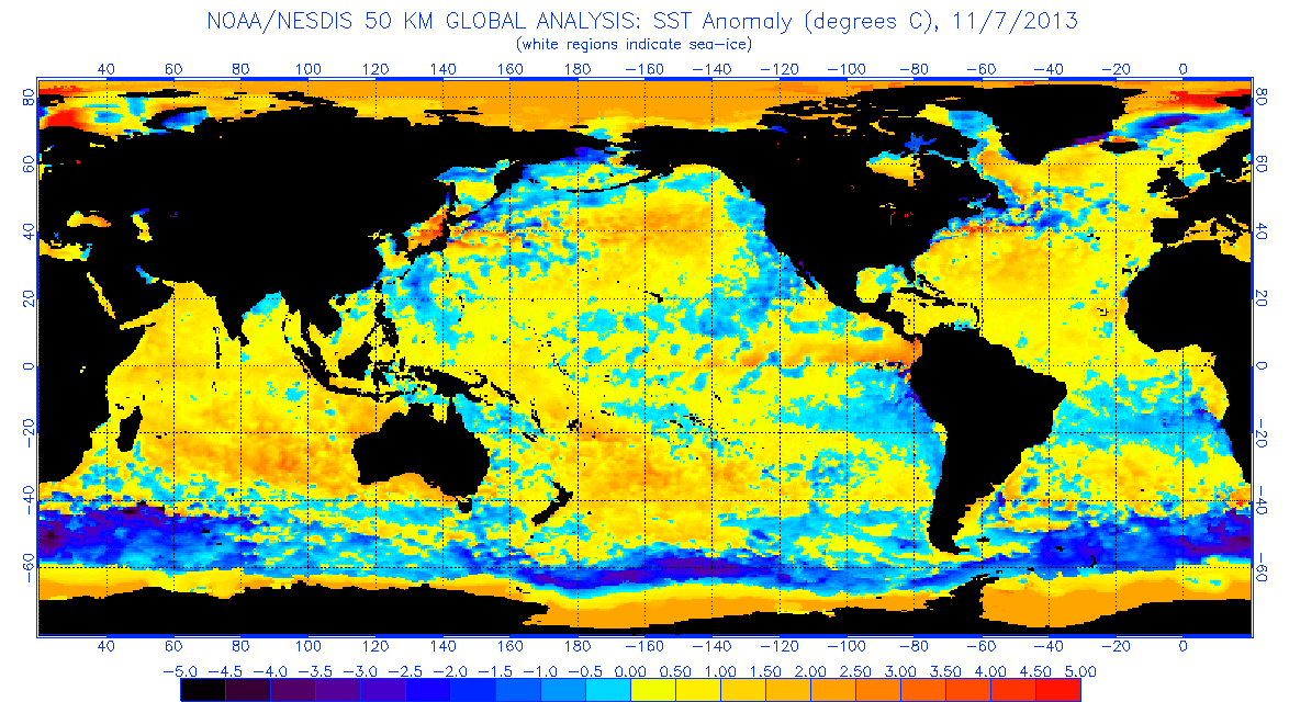
Yes.. Tat particular area has got ocean thermal energy exceeding 70kj, sst 29, very high tchp and moreover shear bit relaxed at mid-upper level.. Tats y it had a severe ts organisation..
surajsr it might be possible to some extent if 30W comes closer to TN. however follow-up systems would come to TN in the last week November or 1st week of December.
One good spell like recent AP’s rainfall enough to cover the deficit.
BOB’s SST anomalies also conductive for 30W to move west to south-west initially. then north-west towards Chennai. SST anomalies are not favorable for the system to go beyond NTN/SAP.
Good morning friends. As per latest insat pic, it is organising into a cyclone and moving sw probably heading to Nagai. Again different models give different pictures. It appears Selcyclone and Ramisrinivas are tracking this 30W well. Let us hope for best
dinuarcher Selcyclone mitansunshine ya.. imd gfs will get a update by 11am.. no use it will be the same gfs update tat v get it early on weatheronline,tropical tidbits..
jon mount Selcyclone yes jon.. the ridge twrds northeast is moving west…still it din takeover the steering…once it gets,system will start moving west-nw…
jon mount Selcyclone yes…jma expecting it to crash into s.central ap…ecmwf expecting it to move central bay…anyway tis is just the initial forecast… 20 possible could occur.
GokulTamilselvam Selcyclone partially strengthend in last 48hrs,, exactly over phase 3,tat favours bay of bengal… http://www.bom.gov.au/climate/mjo/graphics/rmm.phase.Last40days.gif
jon mount KarthikStorm_T.Nagar
Yes, rains are concentrated towards the northern bands in forecasts. Even now, it has much better defined northern banding.
Something around Pondicherry or Cuddalore would be ideal.


Probably met picked it up from ECMWF – which is extremely bullish about rains for us and it talks of solid rainfall for the entire state for a week or so…whereas GFS is pushing it to Monday..and later.
Gud morning..

Wind animation says landfall near ramayapattnam in s-ap
IMD GFS takes it to North AP with nothing major for us.
it increases the forecast
http://www.wetterzentrale.de/pics/MS_Madras_Indien_avn.png
RaijinWeather
Good Morning
Good Morning bloggers.. cloudy start to the day in chennai
some cumulus forming over East
http://www.imdchennai.gov.in/WRFr72.html
IMD says good NEM rainfall. how it can say the system to go to N.AP at the peak season?
ecmwf last nite update again shows pulicat landfall…
In fact 30W is very different system (not like phailin). It gives more challenge for weather models in terms of intensity and track.
According to my expectation it shouldn’t go beyond NTN and SAP landfall.
Massive organisation 😀
As it would be in organizing state for next 48 h, 30W still follows West to south-west path and enter south central BOB around SE to TN (Chennai) and NE to Srilanka.
From there it would starts its journey towards Chennai by flowing west to north-west/ north to north-west direction???
Hi can u please provide a link where dey say that..
Yes.. Tat particular area has got ocean thermal energy exceeding 70kj, sst 29, very high tchp and moreover shear bit relaxed at mid-upper level.. Tats y it had a severe ts organisation..
IMD’s prediction for 2013 NEM forecast
Click to access press_ne2013.pdf
Is that still possible now?
surajsr it might be possible to some extent if 30W comes closer to TN. however follow-up systems would come to TN in the last week November or 1st week of December.
One good spell like recent AP’s rainfall enough to cover the deficit.
Its good to know that all is not over yet
BOB’s SST anomalies also conductive for 30W to move west to south-west initially. then north-west towards Chennai. SST anomalies are not favorable for the system to go beyond NTN/SAP.
Will it take almost Nilam’s path ?Or else are there any chances of it to take Nisha’s path if it reaches near Sri Lankan coast?
GokulTamilselvam it looks 30W to follow the paths in between NILAM-2012 and BAAZ-20005.
TN would get NISHA-2008 type in last week November/first week December (before 15th at least). Its sure we will be having one NISHA this year.
Good morning friends. As per latest insat pic, it is organising into a cyclone and moving sw probably heading to Nagai. Again different models give different pictures. It appears Selcyclone and Ramisrinivas are tracking this 30W well. Let us hope for best
Kalyan_nanganallur 30W is very different cyclone and challenging for regular models in prediction of intensity and track.
Kalyan_nanganallur it wil change its moving direction hpa twrds n-ne moves west …
super inflow from s-sw. http://s17.postimg.org/76uhqh3zj/LATEST.jpg
itis a cloudy start to the day
its doubt that we get a rain
http://tropic.ssec.wisc.edu/real-time/indian/winds/wm5dvg.GIF divergence increasing staedily…tis is intensifying.
steadily
Selcyclone whatt???????????/i cannot understand
Guys a bad news…imd is taking it towards north andhra…may b a cyclone
http://www.imd.gov.in/section/nhac/dynamic/nwp/120hgfs_925wind.htm
mitansunshine tat is not imd official cyclone track…its none other than a replica of gfs
Selcyclone mitansunshine Exactly Selva.. Infact outdated GFS replica.. Iam i right?
Selcyclone i think its moving in a WSW’ly dir
dinuarcher Selcyclone mitansunshine ya.. imd gfs will get a update by 11am.. no use it will be the same gfs update tat v get it early on weatheronline,tropical tidbits..
Sel if u r right….den its okkkk
mitansunshine it wont move N.. HPA is around
jon mount Selcyclone yes jon.. the ridge twrds northeast is moving west…still it din takeover the steering…once it gets,system will start moving west-nw…
gfs expecting another depression around 20th
http://monsoondata.org/wx/prec.html
System steadily moving in WSW direction till now, ideal track for us.
Jon yes i know it bt little confused by imd replica
heavy fog outside
jon mount tis is samething wat mitan posted moving twrds bangla…last update said it was moving twrds bangla.
jon mount where are u ?
Selcyclone jon mount as per cola map nxt dep is targetting TN(delta dist)
Selcyclone Really good divergence aloft, Selva , good signs rite , ?
Selcyclone jon mount s it was bangla in the prev update
Hpa has extended u
jon mount Selcyclone yes…jma expecting it to crash into s.central ap…ecmwf expecting it to move central bay…anyway tis is just the initial forecast… 20 possible could occur.
Karthik i think it will start moving west from nw
GokulTamilselvam jon mount adambakkam.. it was very foggy in verlachery 100ft road
Any possibility of moisture being driven into our system from the system forming near Sumatra, by way of cross equatorial flow?
GokulTamilselvam Selcyclone yes….ofcourse
jon mount GokulTamilselvam Oh okay okay , it has nothing to do in reducing our spirits, ////////////////////
jon mount GokulTamilselvam hpa extending from arb sea is seen at mid low level…tats the reason.
mitansunshine
May continue WSW for maybe one or two more updates and then start moving perfect west followed by WNW.
hope it move straight wsw
gfs still predicting gud rains for entire TN from 17th
http://www.weatheronline.in/cgi-bin/expertcharts?LANG=in&MENU=0000000000&CONT=swas&MODELL=gfs&MODELLTYP=1&BASE=-&VAR=pr06&HH=180&LOOP=1&ZOOM=0&ARCHIV=0&RES=0&WMO=
even foreca expecting rains from 17th
http://www.foreca.com/India/Union_Territory_of_Puducherry/karaikal?tenday
http://www.foreca.com/India/State_of_Tamil_Nadu/Chennai?tenday
System has really organised very well overnight. Good convection seen and it has consolidated well.

Selcyclone Where is the current location of MJO pulse Selva ??
Hope this system moves towards us.
Selcyclone Any chances of dry air availability for this system from the surrounding , I am bit worried that should not be the case
THE AREA OF CONVECTION (REMNANTS OF TD 30W) PREVIOUSLY
LOCATED NEAR 13.1N 93.4E IS NOW LOCATED NEAR 12.4N 89.5E
so it has moved WSW
GokulTamilselvam Selcyclone partially strengthend in last 48hrs,, exactly over phase 3,tat favours bay of bengal… http://www.bom.gov.au/climate/mjo/graphics/rmm.phase.Last40days.gif
JTWC also assures of steady development as it moves westward. Looks really positive for us till now.
http://www.weatheronline.co.uk/cgi-app/satellite?CONT=world&CREG=awif&LOOP=24&LANG=en&STRUCTUR
SYSTEM HAS GOOD SHAPE
animate the gif forward http://www.atmos.albany.edu/facstaff/roundy/tcforecast/tcforecast.html
KarthikStorm_T.Nagar system needs to make landfall S of chennai for us to have any significant rains
From 15th to 17th today.
Tomorrow 17th to ?
i have question how many system says its in to andra
i have question how many system says its go to andra
jon mount KarthikStorm_T.Nagar
Yes, rains are concentrated towards the northern bands in forecasts. Even now, it has much better defined northern banding.
Something around Pondicherry or Cuddalore would be ideal.
probably the foggiest morning of the year so far in bangalore…
we have good wet week ahead
http://monsoondata.org/wx/chengfs.png
Martin_Bangalore entire s.peninsula is under cover of the arabian ridge,,,,nagai,s,tn escapes.
today fog was because of cloudy day
keaweather puriyala
sel hope its happen
good cloud cover here
Rains were suppose to start from 15th according to cola. Now they postponed to 17th.
What they will say tomorrow? 19th?
Selcyclone
As JTWC mentioned, probability of TC improving as it moves westward.
keaweather true.. 😦
will the approaching western disturbance push the developing cyclone eastwards or will the ridge play major role?
tropical weather advisories by JTWC

atharwasim1 Even the Business Line news article has said that the approaching Western Disturbance might take the rains to Orissa
tropical typhoon formation alert by JTWC in the same path of super typhoon haiyan

atharwasim1only ridge….
ramisettisrinivasa Hope a ridge develops to the north of the system and take it into our Bay Of Bengal //////////////
GokulTamilselvam ramisettisrinivasa INITIAL FORECAST SUGGEST TAT IT IS EXPECTED TO MOVE INTO BAY…MAJOR MODELS ECMWF,JMA,GFS BRINGS IT INTO BAY
SelcycloneGood to hear Selva , this time your confidence is much higher and it seems to thrash all the odd factors
Selcyclone GokulTamilselvam ramisettisrinivasa Really!!!!! then lets see //////////
drizzles here in ayanavaram with one or two drops
awesome weather here look beautiful with fog its Chennai or ooty