Intensifying at a rapid state.. If the uL anticyclone continues to be with the LLC,IT would attain a DD in a peroid of 18 hrs…it is providing such a low shear and terrific outflow..
As i told, wat ever intensification it needs, shld happen bfore 83 E,..Tchp is very low in sw bay. AN AREA OF CONVECTION HAS PERSISTED NEAR 9.5N 90.9E,APPROXIMATELY 670 NM EAST-NORTHEAST OF COLOMBO, SRI LANKA. RECENTANIMATED INFRARED SATELLITE IMAGERY SHOWS DEEP CONVECTION FLARINGOVER A DEVELOPING LOW LEVEL CIRCULATION CENTER (LLCC) EVIDENT IN A292104Z AMSU-B PASS. THIS DISTURBANCE LIES BENEATH AN UPPERLEVELRIDGE AXIS, WITH LOW VERTICAL WIND SHEAR AND FAVORABLE DIFFLUENCEALOFT. HOWEVER, THE LLCC IS EXPECTED TO MOVE WESTWARD INTO AN AREA OFHIGHER VERTICAL WIND SHEAR AND WILL LIKELY ENTRAIN DRIER AIR PRESENTACROSS THE WESTERN BAY OF BENGAL IN THE DAYS AHEAD, LIMITING THE TIMEWINDOW FOR FURTHER DEVELOPMENT. MAXIMUM SUSTAINED SURFACE WINDS AREESTIMATED AT 20 TO 25 KNOTS. MINIMUM SEA LEVEL PRESSURE IS ESTIMATEDTO BE NEAR 1005 MB. BECAUSE THE LLCC IS JUST BEGINNING TO DEVELOP,THE POTENTIAL FOR THE DEVELOPMENT OF A SIGNIFICANT TROPICAL CYCLONEWITHIN THE NEXT 24 HOURS IS LOW
An area of convection has persisted near 9.5n 90.9e, approximately 670 nm east-northeast of colombo, sri lanka. Recent animated infrared satellite imagery shows deep convection flaring over a developing low level circulation center (llcc) evident in a 292104z amsu-b pass. This disturbance lies beneath an upper level ridge axis, with low vertical wind shear and favorable diffluence aloft.
However, the llcc is expected to move westward into an area of higher vertical wind shear and will likely entrain drier air present across the western bay of bengal in the days ahead, limiting the time window for further development. Maximum sustained surface winds are estimated at 20 to 25 knots.
Minimum sea level pressure is estimated to be near 1005 mb. Because the llcc is just beginning to develop, THE POTENTIAL FOR THE DEVELOPMENT OF A SIGNIFICANT TROPICAL CYCLONE WITHIN THE NEXT 24 HOURS IS LOW.
You’re thinking cloud seeding.Sure,it is very possible.First,we need heavy array of clouds.
It is also not always beneficial.Beijing scientists embarrassed themselves by bringing snow instead of rain due to excessive cloud seeding.
It’s cost is also too high.So,it is usually used as a last ditch attempt for survival.Nature always tends to punch you in the face when you deconstruct it in any way.
Thanks a lot Mr Karthikstorm for enhancing my knowledge… i believe Tamil nadu too tried it once…but i don’t remember which year it was!!
Ah,Drop the formalities. 🙂
The year was 1973, 1975-1977..Attempted by IIT-M in Tiruvallur.
Not sure it was widely successful.
Sw bay la intensify aaga chance kammi.. Shear factor will b equalised by ULA ,marginal fav SST , only concern is dry air…. Hope it doesnt destroy the system badly, sw bay shld maintain the intensity atleast…
Why is this shear and dry air playing havoc in our monsoon?
Why can’t we get a non-sheared system for once?
Selvan,how is this gonna go forward?Will we get a system or dry air oothi mudirima?
If it intensifies in to a cyclone, which is it is going to be, then need not to fear. TCs have their own way of dealing with dry airs and wind shears if they are strong enough.
03B was a wuss,I suppose.
Anyway,let’s hope this one become too mature for such trivial things.
The Hindu is quite brutal in its statistical evaluation – this November is the worst in terms of rainfall in the last 43 years. Yes – you read that right- past FORTY THREE years !
Thats a lot of records that just crumbled.
Looking at BBC and GFS forecasts, I am kind of getting the again feeling. System sheared and sheared and we get the leftovers. Will and how will it be different this time?
Important Breaking News:They found water on Mercury .
Ice water was seen in the craters at the poles.Neutron spectrometry found evidence of high amounts of hydrogen.Thermal and topography models match what was found in other tests and further confirm water ice in the dark sides of the craters.
Oh,lord.
NASA’s messenger brings about this absolutely mind-boggling revelation.
Just for you guys to know,Mercury is 630 °C .They found water in it.
The world is too big for us.
Every planet right next to us has water and we’re searching light years away.
The principal vorticity is trying to swallow all other vorticity around it. That is OK as it helps system to become stronger. But it should remain stationary or move very slowly in a favorable atmosphere and intensify as much as possible.
As soon as the main system swallows the bits and pieces around it and undergoes circulation,it’s intensification will be rapid.
Right now,the main circulation is losing strength a bit,but not to worry at all.Wait for it.
Karthik,ipothku danger ila..83E longitude varaikum it is highly favourable for steady intensification.. If it stays behind east of 83E for next 36 hrs,it wil be a tropical storm .Dry air interaction ithu varaikum ila , if it interacts,it may weaken to Wml or D or may even dissipates wen it nears the coast…. Lets c.
Hi Guys…this is srshankar…a weather enthu…following your posts and comments for an year and posting for the first time. Amazing job with the kea site and this blog.
Latest RAMMB images shows that the bottom circulation is pulling and swallowing the main vorticity.This will give it more time for intensification.
Also it has move west more,so all in all,better for us atm.
System induced Upper level anticyclone ,LLC pakkathlayae iruntha it wil provide low shear of 5-10knts In tat case ,shear oru problem aa irukathu.. Dry air 4m ridge is the only worrying factor..
Hi Guys…this is srshankar…a weather enthu…following your posts and comments for an year and posting for the first time. Amazing job with the kea site and this blog
North pogathu,.. West or West-sw r the two available choices .. 11.30 update la mid -tropo (500mb)wind direction eppudi ne paakalam. It wil strictly follow it and also ecmwf update.. Everythng wil b clear in few hours.
If the anticyclone is the cause of dry cold air I hope it moves up in time for good rains to reach us. I see minimum temps going up from tomorrow. Hope thats a good sign. Iam not expecting a cyclone but some amazing rains to compensate for all the disappointment and frustration. This dry air has to go away and hope wind shear comes down enough for buckets of rain.
Abundant water vapour present to the east of the system near Andamans.Since the circulation is anti-clockwise,I hope it eats up all the water vapour and gets ready for the showdown.
can someone tie a rope with 30knots to a helicopter or navy ship and pull it down below india…bloody shears trying to spoiling my dreams of december dd’s
Please someone request TN Government to take immediate steps to spray water from helicopter over the dry air area…so it will become moisturized area until the system reach us
seeing the WML in the bay…it seems nisha is on the cards for Chennai. The Depression will cross above GoM….but Chennai will get the bulk of rains from the outer bands rich of rains.
During Nisha Orathanadu, Thanjavur District where over 660 mm of rain fell within a period of 24 hours and broke the 65-year old record of highest rainfall registered in 24 hours in Cuddalore,Tamil Nadu.
As Pradeep said that it the current system is similar to that of Nisha, Will Chennai broke that record?
As northern hemisphere is slowly slipping into winter including india, we hope to see winter dose not set in by end of december so that at least we have an our share of rain.. I hope this time around there will be less number deaths due to cold winter in northern india.
Iam a lay man as somebody said some days back, so for me tell me when it is likely to rain thats it. I dont understand these charts and maps! Rain or No!
Surely the ridge will be pushed towards north. As of now the ridge is at 13N.
Also the moisture was absent yesterday over central and north bay. Today’s water vapour insat shows that there are some moisture over south coastal ap, the dry air is vanishing over that region.
how much the intensity of the system should reach for getting updates every 30 minutes?
I didn’t know Kea’s gravatar change would spark such a butterfly change.If I’d know,I would have made one earlier.
All tables tipped toward Chennai at the moment.
Surely the ridge will be pushed towards north. As of now the ridge is at 13N.
Also the moisture was absent yesterday over central and north bay. Today’s water vapour insat shows that there are some moisture over south coastal ap, the dry air is vanishing over that region.


its 99B.. Navy nrl started to monitor.
Intensifying at a rapid state.. If the uL anticyclone continues to be with the LLC,IT would attain a DD in a peroid of 18 hrs…it is providing such a low shear and terrific outflow..
yea.. the upper level anti cyclone plays an important role now !! Hope it doesn’t misses the LLCC in the system’s progress..
even could be much bfr that,
GM HR649!
At 1004mb with 25knts , …
here it is !! our 99B’s track page…
http://rammb.cira.colostate.edu/products/tc_realtime/storm.asp?storm_identifier=IO992012
Current position :- 10.2N, 91.2E, Intensity 15 kts
Wind Analysis :-
Shear to the north and South…
Hi Sel GM,
see the CTT at -70 deg
http://www.imd.gov.in/section/satmet/dynamic/iso.htm
position 10.2N 91.2E
looks fantastic
Navy NRL’s TC Page :-
http://www.nrlmry.navy.mil/tc-bin/tc_home2.cgi?YEAR=2012&MO=11&BASIN=IO&STORM_NAME=99B.INVEST&PROD=track_vis&PHOT=yes&ARCHIVE=active&NAV=tc&AGE=Latest&SIZE=Thumb&STYLE=tables&AID_DIR=/SATPRODUCTS/TC/tc12/IO/26W.BOPHA/tpw/microvap&TYPE=ssmi
Latest Wind shear :-
Vorticity :-
The circulation is quite large
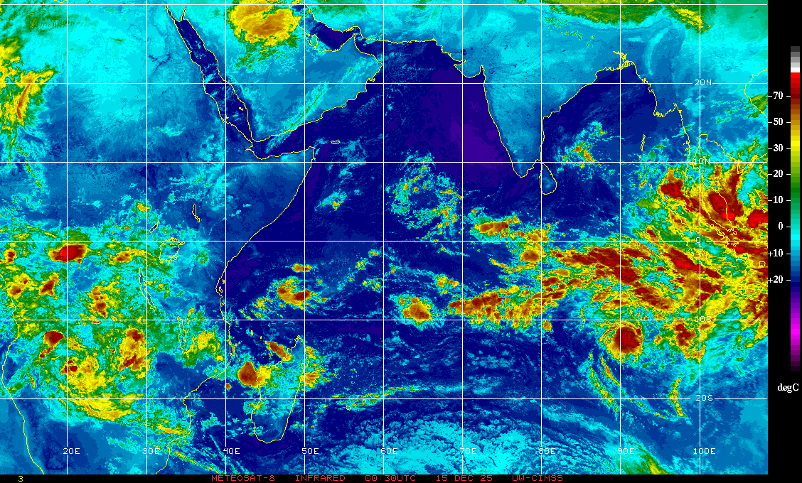
getting in shape…… http://www.imd.gov.in/section/satmet/img/sector-ir.jpg
Ya.very Gud Morning cat5, and hr649… vettai aarambamaichu doi..
Gud mrg guys !! Busy day ahead !!
Looks like if the trnd continues, we may see rains from 2nd itself!
hope this time it happens
It shld throw minor thunder storms soon since its below our latitude…
latest satellite image. good intensification!
Clear Sky, Min. Temp. drops to 20*C here in Guindy………..
As i told, wat ever intensification it needs, shld happen bfore 83 E,..Tchp is very low in sw bay. AN AREA OF CONVECTION HAS PERSISTED NEAR 9.5N 90.9E,APPROXIMATELY 670 NM EAST-NORTHEAST OF COLOMBO, SRI LANKA. RECENTANIMATED INFRARED SATELLITE IMAGERY SHOWS DEEP CONVECTION FLARINGOVER A DEVELOPING LOW LEVEL CIRCULATION CENTER (LLCC) EVIDENT IN A292104Z AMSU-B PASS. THIS DISTURBANCE LIES BENEATH AN UPPERLEVELRIDGE AXIS, WITH LOW VERTICAL WIND SHEAR AND FAVORABLE DIFFLUENCEALOFT. HOWEVER, THE LLCC IS EXPECTED TO MOVE WESTWARD INTO AN AREA OFHIGHER VERTICAL WIND SHEAR AND WILL LIKELY ENTRAIN DRIER AIR PRESENTACROSS THE WESTERN BAY OF BENGAL IN THE DAYS AHEAD, LIMITING THE TIMEWINDOW FOR FURTHER DEVELOPMENT. MAXIMUM SUSTAINED SURFACE WINDS AREESTIMATED AT 20 TO 25 KNOTS. MINIMUM SEA LEVEL PRESSURE IS ESTIMATEDTO BE NEAR 1005 MB. BECAUSE THE LLCC IS JUST BEGINNING TO DEVELOP,THE POTENTIAL FOR THE DEVELOPMENT OF A SIGNIFICANT TROPICAL CYCLONEWITHIN THE NEXT 24 HOURS IS LOW
C the culprit ,only dry air is left in sw bay.. http://www.aoml.noaa.gov/phod/dataphod1/work/HHP/NEW/2012333ni.jpg
Bay na chumma vaa… Lets c
Here goes the JTWC’s text :-
An area of convection has persisted near 9.5n 90.9e, approximately 670 nm east-northeast of colombo, sri lanka. Recent animated infrared satellite imagery shows deep convection flaring over a developing low level circulation center (llcc) evident in a 292104z amsu-b pass. This disturbance lies beneath an upper level ridge axis, with low vertical wind shear and favorable diffluence aloft.
However, the llcc is expected to move westward into an area of higher vertical wind shear and will likely entrain drier air present across the western bay of bengal in the days ahead, limiting the time window for further development. Maximum sustained surface winds are estimated at 20 to 25 knots.
Minimum sea level pressure is estimated to be near 1005 mb. Because the llcc is just beginning to develop, THE POTENTIAL FOR THE DEVELOPMENT OF A SIGNIFICANT TROPICAL CYCLONE WITHIN THE NEXT 24 HOURS IS LOW.
Sat image, full disk view :- http://www.usno.navy.mil/NOOC/nmfc-ph/RSS/jtwc/ab/abiosair.jpg
Low in bay to move west and north west to get rains
Clear blue skies with sun coming out in fully glory! This is the current weather conditions in Chennai and I go by it. Seeing is BELIEVING!
850hpa winds
Cloud motion vectors :-
Guys, i have a question…. is it possible to bring down rains by dropping silver nitrite over the rain barren clouds?
Sriramdorain – No and no and no.
You’re thinking cloud seeding.Sure,it is very possible.First,we need heavy array of clouds.
It is also not always beneficial.Beijing scientists embarrassed themselves by bringing snow instead of rain due to excessive cloud seeding.
It’s cost is also too high.So,it is usually used as a last ditch attempt for survival.Nature always tends to punch you in the face when you deconstruct it in any way.
Thanks a lot Mr Karthikstorm for enhancing my knowledge… i believe Tamil nadu too tried it once…but i don’t remember which year it was!!
Ah,Drop the formalities. 🙂
The year was 1973, 1975-1977..Attempted by IIT-M in Tiruvallur.
Not sure it was widely successful.
Sw bay la intensify aaga chance kammi.. Shear factor will b equalised by ULA ,marginal fav SST , only concern is dry air…. Hope it doesnt destroy the system badly, sw bay shld maintain the intensity atleast…
Hey,guys.Good morning.Today’s gonna be a long day huh?!
Late vanthalum latest-a varumma ??
Why is this shear and dry air playing havoc in our monsoon?
Why can’t we get a non-sheared system for once?
Selvan,how is this gonna go forward?Will we get a system or dry air oothi mudirima?
If it intensifies in to a cyclone, which is it is going to be, then need not to fear. TCs have their own way of dealing with dry airs and wind shears if they are strong enough.
03B was a wuss,I suppose.
Anyway,let’s hope this one become too mature for such trivial things.
The Hindu is quite brutal in its statistical evaluation – this November is the worst in terms of rainfall in the last 43 years. Yes – you read that right- past FORTY THREE years !
Thats a lot of records that just crumbled.
Is this also the November where maximum number of bloggers turned up at KEA blog to talk of no rain I wonder ?
We need the heat and humidity back !
Speak for yourself. 😛 IF heat and humidity meant rains we should be bigger than chirapunjee
😆 .
For people waking up right now.This is what we are excited about.

Hey maan will it bring the rains? thats the question, seen many images like that in Nov.
It sure has rains in it.This is a significant improvement for our cold and dry NEM.Will it come to us?Time will tell.
hmm a very diplomatic answer, time will tell, Worst Nov in 43-years as of by the reports. Drastic improvement in weather needed in Dec.
That looks good enough for me to change my Dec forecast!
Pessimists-Hear,hear.
I may think more realistically after a cup of coffee 😉
One stubborn fella you are.
November is record breaking dry period. Worst in 43 years.
December is also going to be record breaking year. Highest rainfall in 75years! Beat it!
Seeing is Believing! As of now clear blue skies.
Rain bands are west of the system. If the same trend is maintained, we can expect heavy downpour.
http://www.nrlmry.navy.mil/htdocs_dyn_met/PUBLIC/tc_pages/pages/tc12/IO/99B.INVEST/amsub/color/2degreeticks/full/20121129.2104.noaa18.x.color_89_150.99BINVEST.15kts-1010mb-102N-912E.100pc.html
It will surely consolidate more.It is possibly at 1004 mB right now.A lot of intensification left.
Looking at BBC and GFS forecasts, I am kind of getting the again feeling. System sheared and sheared and we get the leftovers. Will and how will it be different this time?
Important Breaking News:They found water on Mercury .
Ice water was seen in the craters at the poles.Neutron spectrometry found evidence of high amounts of hydrogen.Thermal and topography models match what was found in other tests and further confirm water ice in the dark sides of the craters.
Oh,lord.
NASA’s messenger brings about this absolutely mind-boggling revelation.
Just for you guys to know,Mercury is 630 °C .They found water in it.
The world is too big for us.
Every planet right next to us has water and we’re searching light years away.
The principal vorticity is trying to swallow all other vorticity around it. That is OK as it helps system to become stronger. But it should remain stationary or move very slowly in a favorable atmosphere and intensify as much as possible.
Intensity is the key here onwards.
http://tropic.ssec.wisc.edu/real-time/windmain.php?&basin=indian&sat=wm5&prod=vor&zoom=Z&time=
Absolutely Vbob.Hope,hope and more hope…
The next 18 hours will determine the fate of this system.Fingers crossed,everyone.
Surely moving in the right direction, westwards i mean..good intensification seen..
As soon as the main system swallows the bits and pieces around it and undergoes circulation,it’s intensification will be rapid.
Right now,the main circulation is losing strength a bit,but not to worry at all.Wait for it.
As of 7.am,..position at 9.5N,90.9E with intensity of 25knts and core pressure at 1004mb..
Boss,Shear and dry air intha muraiyum sangu udhiruma?
Karthik,ipothku danger ila..83E longitude varaikum it is highly favourable for steady intensification.. If it stays behind east of 83E for next 36 hrs,it wil be a tropical storm .Dry air interaction ithu varaikum ila , if it interacts,it may weaken to Wml or D or may even dissipates wen it nears the coast…. Lets c.
Ayyayo.
Hope the dry air in it’s path lessens.Today’s hours crucial,then.
Lets close the contest midnight of tonight. Anybody want to make changes can do so too.
Guess a big day ahead
Hi Guys…this is srshankar…a weather enthu…following your posts and comments for an year and posting for the first time. Amazing job with the kea site and this blog.
kindly update my DEC predictions
kea..
My predictions for December
Total Rainfall : 650 mm
No of 20mm+ Rainy days : 11 days
Highest 48hr Rainfall :250 mm
Latest RAMMB images shows that the bottom circulation is pulling and swallowing the main vorticity.This will give it more time for intensification.
Also it has move west more,so all in all,better for us atm.
System induced Upper level anticyclone ,LLC pakkathlayae iruntha it wil provide low shear of 5-10knts In tat case ,shear oru problem aa irukathu.. Dry air 4m ridge is the only worrying factor..
It’s North movement must be as constricted as possible,illiya?So west is the only favourable direction right now..
Hi Guys…this is srshankar…a weather enthu…following your posts and comments for an year and posting for the first time. Amazing job with the kea site and this blog
Warm Welcome to the Blog. 🙂
Thank you. 🙂
Hope you stay active.
Ennai welcome seidhadhakku nandri. I get inactive and sheared
when there is high pressure. 🙂
Try to intensify. 😀
Ecmwf shows as if the entire drama is ending in next 72 hours…. Nagai -jaffna is the target til now..
North pogathu,.. West or West-sw r the two available choices .. 11.30 update la mid -tropo (500mb)wind direction eppudi ne paakalam. It wil strictly follow it and also ecmwf update.. Everythng wil b clear in few hours.
Santhosham.11.30-crucial.Phew.
If the anticyclone is the cause of dry cold air I hope it moves up in time for good rains to reach us. I see minimum temps going up from tomorrow. Hope thats a good sign. Iam not expecting a cyclone but some amazing rains to compensate for all the disappointment and frustration. This dry air has to go away and hope wind shear comes down enough for buckets of rain.
Abundant water vapour present to the east of the system near Andamans.Since the circulation is anti-clockwise,I hope it eats up all the water vapour and gets ready for the showdown.
hi..
any rainfall for S.Tn on Monday… i m moving to karaikkudi for func tonite and back to chennai on wed morng…
any rain expected in this 4 days…
Not really carved in stone.But for south T.N rain can be expected from 2nd or 3rd.So,plan accordingly. 🙂
thanks karthik
Dr.Sel says next 36-48 hours crucial for patient to survive
Hi Guys,
Good Chilly Morning.
Test match starting between Laddu Vs Bussvanam today
1.Whether test match will continue for 5 days ?
2.Is this low scoring match ?
What other questions running in our bloggers mind ?
3.How is the pitch?Rank turner or bouncy?
4.What will be the score at the end of day’s play?
5.Whether ball(system) will swing away in dry air ?
Threatening WV insat…
http://www.imd.gov.in/section/nhac/dynamic/Monsoon_frame.htm
No the system has intesified into Well marked LPA.
Raja sir, marundhu velai seyyanum, ill na patient eranthuruvaru… Athku hospital porupaagathu.
BGM-*oppari*
Hospital will be vandalised ! Be careful Dr.
Karthik,Lol.. Along with drums n sangu.
😆
9.5N 90.9E
Intensity-25.
Last intensity reading was 15. 😀
Wind shear at 30 knots should clear up.
http://tropic.ssec.wisc.edu/real-time/windmain.php?&basin=indian&sat=wm5&prod=shr&zoom=Z&time=
can someone tie a rope with 30knots to a helicopter or navy ship and pull it down below india…bloody shears trying to spoiling my dreams of december dd’s
Dont worry it should clear up by tomorrow.
Divergence is covering very long area.
http://tropic.ssec.wisc.edu/real-time/windmain.php?&basin=indian&sat=wm5&prod=dvg&zoom=Z&time=
Shear to decrease by almost 20 knots across bay. Yay.This will do wonders for the system.
http://www.meteo.psu.edu/~fxg1/COMPSHEARIOCN_12z/comploop.html
i don’t like the first digit of that number(20)….can someone erase that
Decrease,boss.So the bigger the number,better for us.
and change the number as 3 so that shear will almost clear in the system path
99.9% marathon cancelled for me. Down with a bug
Sorry to hear.Hope you get better in time.This cold weather is bringing down people like The Plague.Same condition here.
Please someone request TN Government to take immediate steps to spray water from helicopter over the dry air area…so it will become moisturized area until the system reach us
How come u got this idea ? Eppadi ?
Ellam ungala follow panni thaan…
Dear Friends,
seeing the WML in the bay…it seems nisha is on the cards for Chennai. The Depression will cross above GoM….but Chennai will get the bulk of rains from the outer bands rich of rains.
As per NRL: 25 kts 1004 mb
its Depression strength already
Good morning,sir.Sure hope so.
It’s intensification has been fast.If it maintains it, and is steady in direction,Nisha-like rains for sure.
Yes…but all depends on shear
as per WRF Derived products
Shear to decrease to 20 kts on 2nd
http://202.54.31.51/wrf/wrfdp.aspx
Nunga
MAX 30.3, MIN 19.5C.
NWP report from IMD.
http://www.imd.gov.in/section/nhac/dynamic/nwp/120hGFSrain.htm
did you saw this?
http://www.imd.gov.in/section/nhac/dynamic/nwp/144hGFSrain.htm
also this
http://www.imd.gov.in/section/nhac/dynamic/nwp/168hGFSrain.htm
worrying thing for chennai…hope it should become false
LLC wrapping up and the entire system binding up to attain the typical structure. http://www.nrlmry.navy.mil/tcdat/tc12/IO/99B.INVEST/vis/geo/1km_zoom/20121130.0300.meteo7.x.vis1km_high.99BINVEST.25kts-1004mb-95N-909E.100pc.jpg
Was just gonna post that.RAMMB’s latest images are in agreement.
NWP MSLP Forecast for 05th. This system will cross as an LPA.
http://www.imd.gov.in/section/nhac/dynamic/nwp/144hgfs_mslp.htm
Oh no…it should cross as DD….
Rai,
We need to wait for today’s update from IMD.
http://www.imd.gov.in/section/nhac/dynamic/nwp/144hgfs_850wind.htm
Wat partha is posting is yestrday’s data wich is a outdated 1.
yes, lets wait for today’s.
partha
the image which u are showing looks like a DD
its not an updated…..version
Why ur predictions for december is more pessimistic compared to Novembers?
When KN said no water for TN. I thought KStorm will post image with “Vadivelu in Englishkaran” showing nothing is there in his shorts packets.
*pockets
Kannula verala vittutanga pa.

Where is Guruji? When will he come back?
Nogaps left us.
Foreca – 30 mm between 3rd and 4th
http://www.foreca.com/India/State_of_Tamil_Nadu/Chennai
Cola – Old update 60mm between 4th and 5th
During Nisha Orathanadu, Thanjavur District where over 660 mm of rain fell within a period of 24 hours and broke the 65-year old record of highest rainfall registered in 24 hours in Cuddalore,Tamil Nadu.
As Pradeep said that it the current system is similar to that of Nisha, Will Chennai broke that record?
you forgot here is the Nisha Rainfall i have compiled in my blog
Orthanadu – 1280 in 4 days….it is the wettest cyclonic rainfall an indian place has got in the history
25.11.2008 Orathanadu 190 mm
26.11.2008 Orathanadu 330 mm
27.11.2008 Orathanadu 660 mm
28.11.2008 Orathanadu 100 mm
http://tamilnaduweatherman.blogspot.in/2011/10/recent-tamil-nadu-cyclones-and-its.html
How it would be if the numbers comes like below…
5.12.2012 Chennai 190 mm
6.12.2012 Chennai 330 mm
7.12.2012 Chennai 660 mm
8.13.2012 Chennai 100 mm
As per WRF Derived products – Shear to decrease to 20 kts on 2nd
http://202.54.31.51/wrf/wrfdp.aspx
Good one.
What all systems have been doing to us this NEM:

GFS forecast.
http://www.meteo.psu.edu/~fxg1/GFSTROPIOCN_0z/gfsloop.html#picture
NOGAPS.
http://www.meteo.psu.edu/~fxg1/NGPTROPIOCN_0z/nogapsloop.html#picture
How it would be if the numbers comes like below
5.12.2012 Chennai 190 mm
6.12.2012 Chennai 330 mm
7.12.2012 Chennai 660 mm
8.13.2012 Chennai 100 mm
Just like the dates, the numbers are unreal too
if orathanadu can get such rains. why chennai can’t get.
Anything can happen, when everything comes in favour…
Chennai’s geographical position does not allow that
I am week in geography..Can u please give some details?
660 romba overuuu
8.12.2012 Chennai 100 mm
what does mm means ? micromilli ?
neenga ippadi than eppavume…kusumbukarar
Aussies on fire. 63/3. Smith, Peterson and Kallis out
so u r enjoying punter’s last game…
KEA,
I have not given my prediction, how did you update it.
Yesterday i and jupi were predicting your prediction.
Please remove my december prediction. I will update. Please wait.
Partha sir
how u expected KEA to predict such a huge values….oh that’s really bad
OKay, anyways everyone can still change till tonight
Tonight?
You have mentioned earlier as 02nd midnight?
Changed to tonight to make it more challenging
Ok good,
Keep your fingers crossed to see my predictions.
I know you are eager, just wait!!!!
The system is cooking something up right now.RAMMB’s latest images shows the two masses engulfed by a single circulation,like two peas in a pod.
Position 9.5N, 90.9E. 25 Knots.
as sel said, it has to reach maximum possible intensity before it touches 83.E as more villians are hiding near our coast
how much ur expecting that this system will have its maximum intensity before reaching 83E
LPA or max D.
that will be too low, because after 83E it has to fight with villans and might lose its intensity
That is why i said it will be D or LPA.
Shear will come down in next few days.
Animation shows looks like 2 laddus splitting.
kea
Please change the closing date of Decmeber contest in the image to 30 November
kea…u didn’t update my Dec contest
Latest GFS.
http://www.weatheronline.co.uk/cgi-bin/expertcharts?LANG=en&MENU=0000000000&CONT=swas&MODELL=gfs&MODELLTYP=1&BASE=-&VAR=prec&HH=120&ZOOM=0&ARCHIV=0&RES=0&WMO=&PERIOD=
Good Morning,
As northern hemisphere is slowly slipping into winter including india, we hope to see winter dose not set in by end of december so that at least we have an our share of rain.. I hope this time around there will be less number deaths due to cold winter in northern india.
I hope worst chennai november comes to end…
sure, the decmeber will have the rains of november’s deficit part also
Iam a lay man as somebody said some days back, so for me tell me when it is likely to rain thats it. I dont understand these charts and maps! Rain or No!
from 4th decmeber, sure the rain will be there upto 6th as of now
rains varum ana enga varumnu theriyathu
Ramanan to Thanthi TV,
Low near andaman, will move towards west. Rain will begin from 03rd.
Intensity this time would be strong.
For sure.
Thanthi TV?
Yes it is new channel,
from Dhina Thanthi.
earlier it was called as NDTV hindu which both ndtv and hindu sold its stake… as it not profit making
really???
yes, why doubt, i saw this in news last night.
This is the time to officially declare.
And the Winner Is………………..
KEA, KEA, KEA…………………….
have to add another KEA…No of contest is 4
As of now,GFS predicts another cyclone with Target as dead centre Chennai.
Not sure whether to feel happy or sad.
hurray…2 confirmed out of my expected 3 in december
http://thehonestintelligence.blogspot.in/2012/11/more-sinkholes-occurring-in-alarming_29.html
Latest update 4m Ncep gfs luks unbelievable..entire chennai-nellore belt to get continous flooding rains for 3 days
Sshhh.Don’ttell.
Let it be a surprise for everyone. 😀
lol…. yea.. no one is gng to believe now..
sakkari pottugonga boss…naan vera konjam overa pesitten…pesikittu irukken
image of system

NCEP GFS.
http://mag.ncep.noaa.gov/NCOMAGWEB/appcontroller?prevPage=Model&MainPage=index&image=&page=Param&cycle=11%2F30%2F2012+00UTC&rname=PRECIP+PARMS&pname=precip_p60&pdesc=&model=GFS&area=ASIA&cat=MODEL+GUIDANCE&fcast=096&areaDesc=Asia&prevArea=ASIA&currKey=model&returnToModel=&imageSize=M
http://mag.ncep.noaa.gov/NCOMAGWEB/appcontroller?prevPage=Model&MainPage=index&image=&page=Param&cycle=11%2F30%2F2012+00UTC&rname=PRECIP+PARMS&pname=precip_p60&pdesc=&model=GFS&area=ASIA&cat=MODEL+GUIDANCE&fcast=120&areaDesc=Asia&prevArea=ASIA&currKey=model&returnToModel=&imageSize=M
http://mag.ncep.noaa.gov/NCOMAGWEB/appcontroller?prevPage=Model&MainPage=index&image=&page=Param&cycle=11%2F30%2F2012+00UTC&rname=PRECIP+PARMS&pname=precip_p60&pdesc=&model=GFS&area=ASIA&cat=MODEL+GUIDANCE&fcast=144&areaDesc=Asia&prevArea=ASIA&currKey=model&returnToModel=&imageSize=M
http://mag.ncep.noaa.gov/NCOMAGWEB/appcontroller?prevPage=Model&MainPage=index&image=&page=Param&cycle=11%2F30%2F2012+00UTC&rname=PRECIP+PARMS&pname=precip_p60&pdesc=&model=GFS&area=ASIA&cat=MODEL+GUIDANCE&fcast=168&areaDesc=Asia&prevArea=ASIA&currKey=model&returnToModel=&imageSize=M
What is this?nothing promising for chennai?
Wait this will be updated as the system becomes well marked.
This is the initial forecast from NCEP.
They predict only in inches.
Gentlemen,our moment has arrived.

NCEP animated MSLP.
http://mag.ncep.noaa.gov/NCOMAGWEB/appcontroller?prevPage=Model&MainPage=index&image=&page=Param&cycle=11%2F30%2F2012+00UTC&rname=SFC-LAYER+PARMS&pname=1000_500_thick&pdesc=&model=GFS&area=ASIA&cat=MODEL+GUIDANCE&fcast=6+Day+Loop&areaDesc=Asia&prevArea=ASIA&currKey=model&returnToModel=&imageSize=M
IMD morning report same as yesterday night LPA formed over anadaman says it will become WML in 48 hrs
therinja visayam dhane..avangala vidunga sir…cyclone pakkathula irundha appove correctana timekku update panna maatanga…
ippoave ethirpartha eppadi
romba naalavae tey are saying tat it’l be well marked in 48hrs..
They r expecting the system to push the ridge north… Tat would be really fine
They are expecting the system to be very well-defined and with higher intensity.
Sel/Karthik,
Surely the ridge will be pushed towards north. As of now the ridge is at 13N.
Also the moisture was absent yesterday over central and north bay. Today’s water vapour insat shows that there are some moisture over south coastal ap, the dry air is vanishing over that region.
how much the intensity of the system should reach for getting updates every 30 minutes?
once the LLCC gets more well defined…
5/71 amazing
What a farewell test this is
Indeed.
I didn’t know Kea’s gravatar change would spark such a butterfly change.If I’d know,I would have made one earlier.
All tables tipped toward Chennai at the moment.
Sel/Karthik/Raijin,
Surely the ridge will be pushed towards north. As of now the ridge is at 13N.
Also the moisture was absent yesterday over central and north bay. Today’s water vapour insat shows that there are some moisture over south coastal ap, the dry air is vanishing over that region.
Cola update has sumthng important to tell…. Chennai likely to get its huge share.
Min. temperature :-
Meena – 19.6
Nunga – 19.5
cuddalore – 20
Nagapattinam – 21.1
Thoothukudi – 22.8
Pamban – 25.8
In southern TN, the temp’s not sinking much… so its the northern coast, still in HPA with cold wave… by tomorrow, temp. will rise to normal 23*c