Had this cyclone been heading towards Mumbai.. even if it is far away this storm would have been blown out of proportion and reported by the media ( NDTV,CNN IBN )
yes exactly or even any drizzle in bangalore will be reported. Baffoons.
and cricket
sel some say that the weakening flag on is it good or bad for rains
Resort guests would be sleeping still? or getting ready to be blown away! Media still not reporting any news about Thane. coverage of lokpall bill in RS.
Its very difficult to know how much rain has fallen because of the wind. My Rain guage shows only 10 mm. It could easily be 2 or 3 times more. Or maybe I am exaggerating
Yes you are exaggerating 🙂 The ground is just wet here and not even a small puddle forming. This is looking like the infamous 96 cyclone where its all wind and no rain 😛
It usually happens everytime.. Nisha din touch the headlines much bcos of mumbai terror attack… even laila had the same,.. jal was free 4m all but it dissipiation made a big headlines…and now thane under lokpal shear… Wat 2 do?
I see someone posted a link to my site here “westernpacificweather.com” thank you very much and also glad someone did cause now I see the reports and great information flowing here. If anyone wants to pass any pictures or videos to me I would love to use them in my next video update.
What are the chsnces for this storm to move closer to Chennai ? What are the rainfall intensities for chennai
I think there is a chance it could wobble North just prior to landfall. Mainly due to friction that often occurs afters systems just make landfall. The models at this link display that occurring. http://wind.mit.edu/~emanuel/temp1t.png
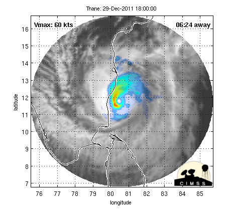
Analysis based on advisory number 14 for THANE-11, published on 12/29/2011 00:00 UTC
•The storm is: active
•Current country: India
•Current position: 82.7, 11.89
•Alert level at current position: orange
•Basin: NorthIndian
•Current strength: Cyclone with Saffir Simpson category 1
•Current maximum sustained wind speed: 38 m/s, 74 kt
THE CYCLONE LIES TO THE WEST OF AN
UPPER-LEVEL ANTICYCLONE. THE UPPER-LEVEL ENVIRONMENT IS MARGINAL,
WITH FAVORABLE BUT DECREASING RADIAL OUTFLOW AND INCREASING VERTICAL
WIND SHEAR. THE CYCLONE IS ALSO MOVING OVER WATERS WITH LOWER HEAT
CONTENT THAT SHOULD, ALONG WITH INCREASING VERTICAL WIND SHEAR AND
DECREASING OUTFLOW, INDUCE SOME WEAKENING PRIOR TO LANDFALL
Up to 3.58 million people can be affected by wind speeds of hurricane strength or above. In addition, 0.12 million people are living in coastal areas below 5m and can therefore be affected by storm surge.
TROPICAL CYCLONE (TC) 06B (THANE), LOCATED APPROXIMATELY 135 NM
SOUTHEAST OF CHENNAI, INDIA, HAS TRACKED WESTWARD AT 06 KNOTS OVER
THE PAST SIX HOURS. ANIMATED MULTISPECTRAL SATELLITE IMAGERY
INDICATES THAT THE SYSTEM HAS INTENSIFIED FURTHER WITH A 15-NM EYE.
A 290245Z SSMIS IMAGE DEPICTS TIGHTLY-CURVED BANDING WRAPPING INTO
THE CENTER WITH THE BULK OF THE DEEP CONVECTION OVER THE WESTERN
SEMI-CIRCLE DUE TO WEAK, EASTERLY VERTICAL WIND SHEAR. THERE IS GOOD
CONFIDENCE IN THE CURRENT POSITION BASED ON THE VISIBLE EYE. THE
CURRENT INTENSITY IS BASED ON DVORAK ESTIMATES RANGING FROM 77 TO 90
KNOTS. TC 06B IS FORECAST TO TRACK WESTWARD, MAKING LANDFALL NEAR
TAU 12, AND IS EXPECTED TO DISSIPATE OVER INDIA BY TAU 36. WITH THE
EXCEPTION OF WBAR, MODEL GUIDANCE IS IN TIGHT AGREEMENT. MAXIMUM
SIGNIFICANT WAVE HEIGHT AT 290600Z IS 22 FEET. NEXT WARNINGS AT
291500Z, 292100Z, 300300Z AND 300900Z.//
shows 2 consecutive 12+ readings..is it wrong?if it is right,system has moved North- west and with the strengthening JTWC says,can be deadly for Chennai..but where are the rains?
got it..i.e.so aan approx 35km stretch can get flattened from the centre of the eye when it crosses..the zest resort and the 15km their South and North
I am very confused..see the latest radar..the eye seem to have gone up North..not NW..plain Northwards..is it an error..if this turn is right,it is heading to ongole / Machilipatnam!
System has moved NW, and lies 250 kms west of Chennai.Superimposed latest position on yesterday’s Map above.
Expect more rains in Chennai as the storm moves NW, forecasted earlier by Vagaries.
Currently at 2 pm (IST) Chennai is a pleasant 22c and overcast with light to medium rains. Winds have notched up to 30 kmph by afternoon.
Very heavy rains and winds expected in Puducherry as the SW segment of the cyclone approaches the region
The cyclone’s northern edge looks reddish….it will make a circular movement and directly hit the Chennai Area…..Chennai in for very heavy rains…all places here could notch up 10cm by 8.30Pm tonight itslef!!


where is it raining in chennai?South Chennai has a drizzle only
latest radar picture shows eye slightly losing shape?
rapid weakening flag on…
Thats good For everybody.
Yes
rapid weakening flag is still off, weakening flag is on
rr n winds picking up all the time
http://www.imd.gov.in/section/dwr/dynamic/doppler-caz.htm
Eye is losing shape
FORECA furthur reduced rainfall. 70 mm for chennai. Is there any reason?
they never increased to reduce
.
Nothing unusual here in cuddalore. It’s just cloudy here. No signs of any rain/wind.
hai sivakumar pls update what is the weather prevailing in and around cuddalore
still its showing westerly movement…
OMG..Foreca predicting the eye to cross near Chennai!
http://www.foreca.com/India/State_of_Tamil_Nadu/Chennai?map=rain
does this means that chennai will get less rainfall???
pouring rain now 🙂
Doppler is showing some intense looking clouds coming in …they are about 25 kms from chennai…..That would be even heavier.
nothing started in pondy as per radar
Chennai geography is more exposed to sea than cdl n pdy.so wait for sometime before the deluge begins there n hopefully ere too 🙂
Very steady heavy spell for a while in BN
tis reminds me of October 27,2005.deep depression tat gave us 42cm of rain in 24hrs 🙂
no overconfidence jon..
Its bucketing here with heavy wind, thats why rain rate is low.
We just toucked the 39 km/hr mark
shivakumar krishna moorthy, r u 4m cuddalore???? if so,stick to this blog so tat v can get updates then n there..
http://www.foreca.com/India/State_of_Tamil_Nadu/Chennai?map=rain
More rains only for south of us..mainly pondy..worst thing is Bengalure may get a lot than expected from Thane 😦
🙂
i couldn’t get the image from the link…details please sel
refresh it….. i think everyone getting it..
http://www.weather.com/weather/today/INXX0202
Shows cloud mass intensity beautifully…The best view so far. Its at 8.30 am this morn.
http://oiswww.eumetsat.org/IPPS/html/MTP/IMAGERY/IR115/COLOR/SOUTHERNASIA/IMAGESDisplay/b8KwumsWXRfuG
Excellent explanation here.
http://westernpacificweather.com/
watch the video
Chennai region likely to witness huge storm surge and he talks about tornadoes also
chennai be aware…
http://westernpacificweather.com/2011/12/29/1933/
imd report out. no suprises yet
storm position;new update shows steady westerly movement…
Cyclone Warning for north Tamilnadu and south Andhra Pradesh coast : Red Message
Orange to Red
OMG its Super Dark here!!!! 😮
another system getting ready in s.china sea…
s…u r correct sel. but that system is going to tarnish Thailand,Vietnam, Malaysia and singapore
KEA WHAT IS THIS we are dead!!! storm peaking gusts at 155kmph
http://www.imd.gov.in/section/nhac/dynamic/cwind.htm
radar looks deadly for chennai -pondi stretch
Oh! Yes…..I am surprised that print and visual media have not focussed much on Thane as yet……
Lokpal made Thane unimportant event for media
Had this cyclone been heading towards Mumbai.. even if it is far away this storm would have been blown out of proportion and reported by the media ( NDTV,CNN IBN )
yes exactly or even any drizzle in bangalore will be reported. Baffoons.
and cricket
sel some say that the weakening flag on is it good or bad for rains
Current landfall area is Zest resort in Pudducherry in Cuddalore road.
Somebody needs to call the property and warn them of the dangers of Thane
Gust of 155 km makes Thane very dangerous…..Its high time Media starts reporting THANE in breaking news …
I have done my bit on facebook
Resort guests would be sleeping still? or getting ready to be blown away! Media still not reporting any news about Thane. coverage of lokpall bill in RS.
Chennai may not bear the brunt!
cdl records 170kmph wind tis morning
http://www.weatheronline.co.uk/weather/maps/city?LANG=en&WMO=43329&TIME=all&CONT=asie&R=0&LEVEL=140®ION=0020&LAND=II&ART=wind&NOREGION=1&PLZ=&PLZN=_____&SORT=__&TEMP=___&WETTER=__&&TYP=__&SEITE=0
am sure it is an error
it has to be 😮
has any area been flooded yet?
Its very difficult to know how much rain has fallen because of the wind. My Rain guage shows only 10 mm. It could easily be 2 or 3 times more. Or maybe I am exaggerating
no flooding here..n yes ur exaggerating..ur rain gauge is perfect
Yes you are exaggerating 🙂 The ground is just wet here and not even a small puddle forming. This is looking like the infamous 96 cyclone where its all wind and no rain 😛
I dont think its too heavy yet – no flooding or even stagnation in BN as of now.
I’m in Singapore,someone please take some videos of the rain
northern periphery sucking up all the moisture so expect flooding in chen
Cyclone worry: SOS to rescue 700 stranded fishermen
Read more at: http://www.ndtv.com/article/india/cyclone-worry-sos-to-rescue-700-stranded-fishermen-161722?pfrom=home-topstories&cp
as expected w n n continues to be the strongest part of the sys
If the same intensity approaches mumbai it would be headlines news everywhere, or even a small drizzle in bangalore.
they will issue warning tomo nite after it crosses the coast 😡
they will say heavy rain to continue for 48 hours and we wil have sunshine on saturday
Baffoons! It maybe a catostrophic event.
power out!!!!! 😦
it will return only by tomo nite 😀 😀
45 % of votes are for over 75 km/hr wind. Maybe I should I included another option for 100 km/hr. I thought its too much for Chennai
s…i too searched for the option..due to the non-availabilty i vote for the maximum
now radar down
next 3 JTWC updates crucial for Chennai
It usually happens everytime.. Nisha din touch the headlines much bcos of mumbai terror attack… even laila had the same,.. jal was free 4m all but it dissipiation made a big headlines…and now thane under lokpal shear… Wat 2 do?
i think obama’s visit was during jal 😀
its getting very dark here in royapuram
The storm is at peak strength according to IMD
THE ESTIMATED CENTRAL PRESSURE IS ABOUT 976 HPA.
http://www.imd.gov.in/section/nhac/dynamic/rsmc.htm
If the system make a lanfall in chennai, i wil turn to stormchaser 4m weather forecaster to record a live coverage 4m marina to tiruvanyumir.
stormy winds picking up now
It will weak from tonight.
Now at 11.87. Is it slightly moving South?
Cola prediction for Chennai is very scary. 160 mm in 6 hours
omg!!!! if it becomes true…then Chennai will be in water since almost all the lakes are at full capacity because of ne monsoon
Omg..IMD predicts THANE to cross pondi as a VERY SEVERE CYCLONE! ….destruction!
I see someone posted a link to my site here “westernpacificweather.com” thank you very much and also glad someone did cause now I see the reports and great information flowing here. If anyone wants to pass any pictures or videos to me I would love to use them in my next video update.
its our pleasure.sure we will try to take some videos 🙂 🙂
Robert,
What are the chsnces for this storm to move closer to Chennai ? What are the rainfall intensities for chennai
I think there is a chance it could wobble North just prior to landfall. Mainly due to friction that often occurs afters systems just make landfall. The models at this link display that occurring. http://wind.mit.edu/~emanuel/temp1t.png
As far as the rainfall intensities that all depends on if some of those bands hit directly over the city. Looking at the most recent rain microwave imagery that seems to be the case and over 50-60mm an hour is highly likely. Defiantly farther to the south will see even more so above 100 an hour.
http://www.nrlmry.navy.mil/htdocs_dyn_pregen_sat/PUBLIC/tc_pages/pages/tc11/IO/06B.THANE/tc_ssmis/rain/2degreeticks/thumb/20111229.0245.f18.x.rain.06BTHANE.75kts-967mb-119N-827E.99pc.html
I hope that helps….
Thanks Rob
rapid weakening flag on
It got flagged on 26th night as well(430-8 pm GMT), but did’nt weaken much then. Lets wait and watch
OMG…SEE THE CURRENT UPDATED RADAAR…THE BEST I HAVE SSEEN EVER SINCE I STARTED FOLLOWING IT!
school over?
ya
i think it has started movin wnw 🙂
No as of now.
north? If it does, dont rule out andhra landfall. Chennai could get 400-600 mm from it
??
Jon,am missing it..now am using my mob.so let me knw the current position and a previous one.
its just my assumption seeing the lat radar.wait for another half an hour
its hvy now along with stormy winds
Which area? In Neelangarai-ECR its just started drizzling
mount
Pretty heavy in BN too. Wind hasnt increased too much
deadly rain bands approaching chn.look at the lat radar 😮
http://imd.gov.in/section/dwr/dynamic/dwr.htm
Omg,brown turning red dot east-n.east of chennai…. Luks threatning as kar mentioned.
Heavy rain in poonamallee.
11.87 -81.80 ON FLG
jon
power came!!!!!! 😀
Still in 11.87 latitude. No sign of North movement?
Foreca changed the prediction. now the cyclone is moving SW after landfall which was NW before.
http://foreca.com/India/State_of_Tamil_Nadu/Chennai?map=rain
😦
Jon, dnt worry, We will get good rains. It will be a disaster if Cyclone crosses over chennai.
Red Message : Danger Danger. PPl in ofc like me .. go home.
Very heavy rain now.
Its hardly drizzling , but wind gusts are pretty heavy to cause huge ripples on standing water
Enjoy!!
Kea, Change the warning color to RED in Kea Website 🙂
Radar image shows system is away 200 KM from Chennai
Movement towards w-nw
Power gone.
s it has moved wnw acc to radar
Rain stopped completely but heavy wind.
12.31 -82.40
thats error for sure, check the next update.
12.47 -82.26 as of 13:30IST shows moving n-w
there is a definite NW tilt now..but the eye is also weakening..hope it does not take a complete N turn and go to S AP
radar looks deadly 🙂 but not reaching 😦
Hi Kea ,
My friend is staying there in Zest resort . I have informed him about the cyclone .
@gopal666
http://www.imd.gov.in/section/nhac/dynamic/qlm.htm
😀
What doest it mean . its not going to land there . how good is that for chennai
Same QLM predicted THane would make landfall in North AP, 2 days back 😛
Very Hvy rain here but winds r just pushing it fast so its not stable.,am sure there is increase in wind speed and rain.
Radar looks … red.
Analysis based on advisory number 14 for THANE-11, published on 12/29/2011 00:00 UTC
•The storm is: active
•Current country: India
•Current position: 82.7, 11.89
•Alert level at current position: orange
•Basin: NorthIndian
•Current strength: Cyclone with Saffir Simpson category 1
•Current maximum sustained wind speed: 38 m/s, 74 kt
GDACS report created on 12/29/2011 4:10:14 AM.
see the latest radar– the eye has disappeared?
or become smaller? Do see a small white patch there in the middle of the circulation
11.8 81.7 jtwc
THE CYCLONE LIES TO THE WEST OF AN
UPPER-LEVEL ANTICYCLONE. THE UPPER-LEVEL ENVIRONMENT IS MARGINAL,
WITH FAVORABLE BUT DECREASING RADIAL OUTFLOW AND INCREASING VERTICAL
WIND SHEAR. THE CYCLONE IS ALSO MOVING OVER WATERS WITH LOWER HEAT
CONTENT THAT SHOULD, ALONG WITH INCREASING VERTICAL WIND SHEAR AND
DECREASING OUTFLOW, INDUCE SOME WEAKENING PRIOR TO LANDFALL
JTWC still expecting landfall @ 11.8 N only
sorry- the eye is back..still going W –in line with Pondy landfall..will it take a decisive turn towards Chennai?nailbiting next few hours!
Affected Population
Up to 3.58 million people can be affected by wind speeds of hurricane strength or above. In addition, 0.12 million people are living in coastal areas below 5m and can therefore be affected by storm surge.
Latest JTWC:
TROPICAL CYCLONE (TC) 06B (THANE), LOCATED APPROXIMATELY 135 NM
SOUTHEAST OF CHENNAI, INDIA, HAS TRACKED WESTWARD AT 06 KNOTS OVER
THE PAST SIX HOURS. ANIMATED MULTISPECTRAL SATELLITE IMAGERY
INDICATES THAT THE SYSTEM HAS INTENSIFIED FURTHER WITH A 15-NM EYE.
A 290245Z SSMIS IMAGE DEPICTS TIGHTLY-CURVED BANDING WRAPPING INTO
THE CENTER WITH THE BULK OF THE DEEP CONVECTION OVER THE WESTERN
SEMI-CIRCLE DUE TO WEAK, EASTERLY VERTICAL WIND SHEAR. THERE IS GOOD
CONFIDENCE IN THE CURRENT POSITION BASED ON THE VISIBLE EYE. THE
CURRENT INTENSITY IS BASED ON DVORAK ESTIMATES RANGING FROM 77 TO 90
KNOTS. TC 06B IS FORECAST TO TRACK WESTWARD, MAKING LANDFALL NEAR
TAU 12, AND IS EXPECTED TO DISSIPATE OVER INDIA BY TAU 36. WITH THE
EXCEPTION OF WBAR, MODEL GUIDANCE IS IN TIGHT AGREEMENT. MAXIMUM
SIGNIFICANT WAVE HEIGHT AT 290600Z IS 22 FEET. NEXT WARNINGS AT
291500Z, 292100Z, 300300Z AND 300900Z.//
Warning 15 from JTWC:THE SYSTEM HAS INTENSIFIED FURTHER WITH A 15-NM EYE..what does it mean?It maintains landfall at 11.7 N
radar is looking deadly for hours.. but nothing is moving inland.. why is it so??
bcoz past 1 hour the movement n-e
http://www.ssd.noaa.gov/PS/TROP/DATA/2011/adt/text/06B-list.txt
it again shows 11.8 @ 830 reading..thats sad
shows 2 consecutive 12+ readings..is it wrong?if it is right,system has moved North- west and with the strengthening JTWC says,can be deadly for Chennai..but where are the rains?
http://tropic.ssec.wisc.edu/real-time/adt/06B-list.txt
Moved northwards now 12.4, 82.14.
Looks like kea’s words are coming true, this is gonna yield < 70 mm
Thane is moving in zigzag manner…so the prediction can’t be exactly…
Now the location is 11.81 -81.80 as 14:00 IST
I think this will cross chennai. And hit it hard.
gopal,it means eye has elongated to 15nm…now eye region is of 15nm or circulation center is of 15nm…eye is exposed well.so they said it intensified..
got it..i.e.so aan approx 35km stretch can get flattened from the centre of the eye when it crosses..the zest resort and the 15km their South and North
Heavy spell started in BN.
From radar, it appears this is the business end of it. Promises to be a long, intense spell.
http://beta.bbc.co.uk/weather/1264527
Radar shows Thane losing eye and shape
Very heavy rain pouring.
area please??
Poonamallee
then sure chembarambakkam water will cross the roads of poonamalle-tirupathi
No. Kunrathur and porur area will be affected.
any latest updated rainfall prediction for chennai?
Thane entering the so-called “Bermuda Traingle of Chennai”..what is goin to happen?????
Cyclone will be defeated by chennai.
y this kolaveri

pouring for the past 10min
Chennai can expect some very heavy rains since northern periphery continues to remain strong
Pouring in Madmabakkam
pouring here for the last 10 mins in annanagar
Pouring now…This is the start of deluge!
2.30pm http://www.nrlmry.navy.mil/htdocs_dyn_pregen_sat/PUBLIC/tc_pages/thumbs/small/tc11/IO/06B.THANE/vis/geo/1km_zoom/20111229.0900.meteo7.x.vis1km_high.06BTHANE.80kts-963mb-118N-821E.100pc.jpg
heavy rains lashing now
my god…..thane at 80knts……………………………..
sel…which report says that thane is at 80knts?link please..
got it..sel
Chennai weather: Fast and furious cyclone headed to city
http://timesofindia.indiatimes.com/city/chennai/Chennai-weather-Fast-and-furious-cyclone-headed-to-city/articleshow/11286933.cms
I am very confused..see the latest radar..the eye seem to have gone up North..not NW..plain Northwards..is it an error..if this turn is right,it is heading to ongole / Machilipatnam!
http://www.imd.gov.in/section/dwr/dynamic/doppler-caz.htm
Report of “Thane” at 2.30 pm IST Thursday:
System has moved NW, and lies 250 kms west of Chennai.Superimposed latest position on yesterday’s Map above.
Expect more rains in Chennai as the storm moves NW, forecasted earlier by Vagaries.
Currently at 2 pm (IST) Chennai is a pleasant 22c and overcast with light to medium rains. Winds have notched up to 30 kmph by afternoon.
Very heavy rains and winds expected in Puducherry as the SW segment of the cyclone approaches the region
Posted by Mr.Rajesh in his website
Oh..no……JTWC has removed Thane!!!
http://www.usno.navy.mil/JTWC/
a blunder
http://www.usno.navy.mil/NOOC/nmfc-ph/RSS/jtwc/ab/abioweb.txt
http://www.nrlmry.navy.mil/tc_pages/tc_home.html
The cyclone’s northern edge looks reddish….it will make a circular movement and directly hit the Chennai Area…..Chennai in for very heavy rains…all places here could notch up 10cm by 8.30Pm tonight itslef!!
The eye is once again visible in Pondi Latitude….the slower THANE moves,the more the rain we get!